
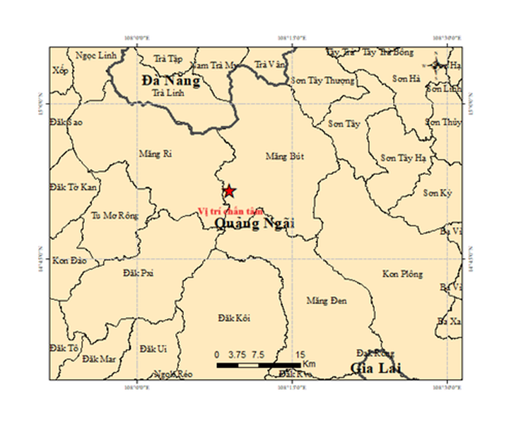
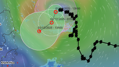
Map of the epicenter of the 3.6 magnitude earthquake that occurred at 3:28 a.m. on October 13 ( Hanoi time)
The most recent earthquake had a magnitude of 3.6, occurred at 3:28 a.m. on October 13 (Hanoi time), with a focal depth of about 8.1 km.
From 1am to 3am on the same day, 5 earthquakes with magnitudes ranging from 2.8 to 4.2 occurred in this area, with a focal depth of about 8.1km. All were at disaster risk level 0.
In addition, in Mang Ri commune ( Quang Ngai province), an earthquake of magnitude 2.5 occurred, with a focal depth of about 8.1km, and a natural disaster risk level of 0.
Previously, at around 1am on October 6, an earthquake of magnitude 4.9 occurred in Mang But commune, a level 1 natural disaster risk.
Also on October 5 and 6, there were dozens of small earthquakes in this area.
According to Mr. Nguyen Xuan Anh, Director of the Earthquake Information and Tsunami Warning Center (Institute of Earth Sciences), this is a trigger earthquake. From 2021 to now, hundreds of earthquakes have been recorded in Quang Ngai (former Kon Tum province, concentrated in the former Kon Plong district), including earthquakes that caused widespread tremors. The largest was the earthquake at noon on July 28, 2024, with a magnitude of 5.
Mr. Nguyen Xuan Anh assessed that "triggered earthquakes" were the cause of earthquakes in recent years in Kon Tum province (old).
"According to preliminary studies, earthquakes in Kon Tum (old) are forecast to continue in the coming time, but the magnitude is unlikely to be greater than 5.5. However, more detailed studies are still needed to assess earthquake activity in this area," said Mr. Anh.
Source: https://tuoitre.vn/sang-nay-lien-tiep-7-tran-dong-dat-o-mang-but-va-mang-ri-20251013073844305.htm


![[Photo] Prime Minister Pham Minh Chinh receives President of Cuba's Latin American News Agency](/_next/image?url=https%3A%2F%2Fvphoto.vietnam.vn%2Fthumb%2F1200x675%2Fvietnam%2Fresource%2FIMAGE%2F2025%2F12%2F01%2F1764569497815_dsc-2890-jpg.webp&w=3840&q=75)


Comment (0)