
Forecast of tropical depression (in the next 12 hours):
Forecast time | Direction, speed | Location | Intensity | Danger zone | Disaster Risk Level (Affected Area) |
13 hours October 23 | Southwest, 10-15km/h | 15.40N-108.00E, on the mainland of Da Nang City - Quang Ngai | Weakens into a low pressure area. | 15.00N-18.50N; West of longitude 110.50E | Level 3: Sea area from Quang Tri to Quang Ngai (including Con Co special zone, Cu Lao Cham island and Ly Son special zone). |
Forecast impact of tropical depression:
At sea: Due to the combined influence of cold air, the sea area from Quang Tri to Quang Ngai (including Con Co special zone, Cu Lao Cham island and Ly Son special zone) has strong winds of level 6, gusts of level 8; waves 2-4m high, rough sea.
Rising water due to strong winds in coastal areas: Coastal areas from Quang Tri Province to Da Nang City have rising water due to strong winds from 0.3-0.6m high.
Warning: Coastal areas and river mouths from South Quang Tri to Da Nang City need to be on guard against large waves combined with high tides and rising water due to strong winds causing flooding in low-lying areas, waves overflowing coastal and riverside roads, and coastal erosion. All ships, boats, and aquaculture areas in the above-mentioned dangerous areas are likely to be affected by storms, whirlwinds, strong winds, large waves, and rising sea levels.
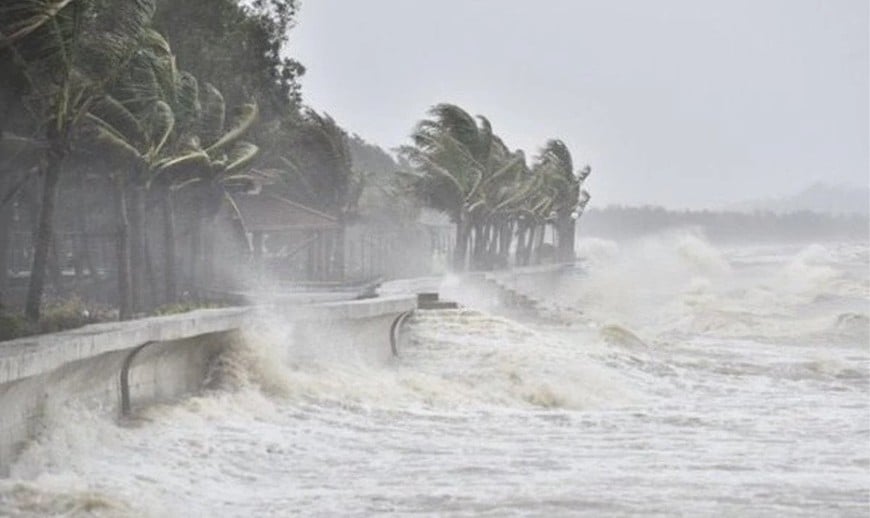
Due to the influence of the tropical low pressure circulation and cold air combined with East wind disturbances and terrain effects, from the night of October 22 to the night of October 24, in the area from Ha Tinh to Quang Ngai, there will be heavy rain and thunderstorms with common rainfall of 100-200mm, locally with very heavy rain over 300mm; in the area from South Quang Tri to Da Nang City, there will be heavy to very heavy rain, with common rainfall of 200-400mm, locally with over 700mm.
Warning of risk of heavy rain (>150mm/3 hours) in coastal communes/wards from South Quang Tri to Da Nang City.
Heavy rains in the Central region are likely to last until the end of October 2025. There is a high risk of flash floods and landslides in mountainous areas, flooding in low-lying areas and urban areas. Localities need to pay attention to the safe operation of hydroelectric and irrigation reservoirs before, during and after the storm, and prepare response plans for flood scenarios on rivers from South Quang Tri to Da Nang that may reach alert levels 2-3, with some places above alert level 3. Forecast level of natural disaster risk due to floods and inundations: Level 2-3.
Weather forecast for regions across the country today (October 23):
Hanoi: Cloudy, sometimes rainy; Northeast wind level 3; cold. Lowest temperature 19-21 degrees Celsius. Highest temperature 24-26 degrees Celsius.
Northwest: Cloudy, with rain in some places; light wind; cold in the morning and at night. Lowest temperature 18-21 degrees Celsius, some places below 17 degrees Celsius. Highest temperature 25-28 degrees Celsius.
Northeast: Cloudy, with rain in some places; scattered rain in the plains and coastal areas; Northeast wind level 3, coastal areas level 4; cold; especially in mountainous areas, cold in the morning and at night. Lowest temperature 18-21 degrees Celsius, in mountainous areas below 17 degrees Celsius. Highest temperature 21-24 degrees Celsius, in some places above 24 degrees Celsius.
From Thanh Hoa to Hue: Cloudy, scattered rain in the North (Thanh Hoa - Nghe An), moderate rain, heavy rain and thunderstorms in the South, locally very heavy rain; especially in South Quang Tri and Hue City there will be heavy to very heavy rain; North to Northwest wind level 3-4; in thunderstorms there is a possibility of tornadoes, lightning and strong gusts; cold in the morning and at night. Lowest temperature 19-22 degrees Celsius. Highest temperature 21-24 degrees Celsius, some places above 24 degrees Celsius.
South Central Coast: The North is cloudy with moderate rain, heavy rain and thunderstorms, locally very heavy rain, especially in Da Nang City; the South is cloudy with scattered showers and thunderstorms in the afternoon and evening, locally heavy rain; Northeast wind level 3-4; in thunderstorms there is a possibility of tornadoes, lightning and strong gusts. Lowest temperature 23-26 degrees Celsius. Highest temperature: North 26-29 degrees Celsius. South 29-32 degrees Celsius.
Central Highlands: Cloudy, scattered showers and thunderstorms; scattered showers and thunderstorms in the afternoon and evening, locally heavy rain; Northeast wind level 2-3; thunderstorms with possibility of tornadoes, lightning, hail and strong gusts. Lowest temperature 19-22 degrees Celsius. Highest temperature 27-30 degrees Celsius, some places over 30 degrees Celsius.
Southern region: Cloudy, scattered showers and thunderstorms, locally heavy rain; light wind; thunderstorms with possibility of tornadoes, lightning, hail and strong gusts. Lowest temperature 23-26 degrees Celsius. Highest temperature 31-34 degrees Celsius.
Source: https://baolangson.vn/thoi-tiet-hom-nay-23-10-bao-so-12-suy-yeu-thanh-ap-thap-nhiet-doi-mien-trung-van-mua-lon-5062626.html


![[Photo] Prime Minister Pham Minh Chinh chairs meeting on railway projects](https://vphoto.vietnam.vn/thumb/1200x675/vietnam/resource/IMAGE/2025/10/23/1761206277171_dsc-9703-jpg.webp)


![[Photo] President Luong Cuong holds talks with South African President Matamela Cyril Ramaphosa](https://vphoto.vietnam.vn/thumb/1200x675/vietnam/resource/IMAGE/2025/10/23/1761221878741_ndo_br_1-8416-jpg.webp)


Comment (0)