
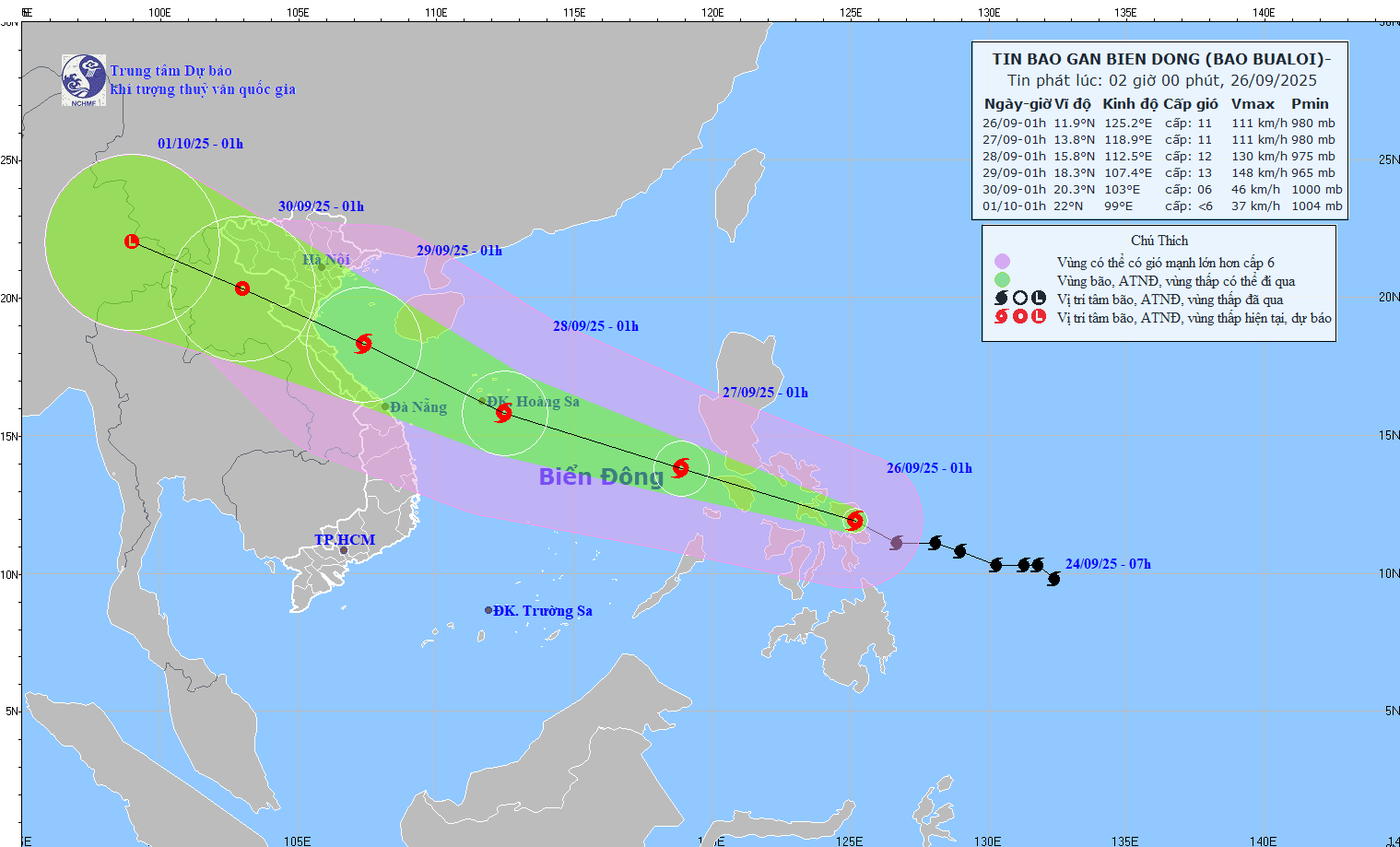
At 1:00 a.m. on September 26, the storm center was at about 11.9°N; 125.2°E, in the central Philippines.
- Strongest wind: level 11 (103–117 km/h), gust level 14.
- Moving West Northwest at 25–30 km/h.
- Forecast: on the night of September 26, the storm will enter the East Sea, becoming storm number 10 in 2025.
📍 Forecast (next 24–72 hours)
- 01:00 September 27 : West Northwest 25-30 km/h, into the East Sea. Position 13.8°N–118.9°E, wind force 11, gusting to level 14.
▪ Danger zone: 11.5–16.5°N; East longitude 116.5°E.
▪ Disaster risk level: level 3 (Northeast and Central East Sea). - 01:00 September 28 : West Northwest 25-30 km/h, likely to strengthen. Location 15.8°N–112.5°E, wind force 12, gusting to level 15.
▪ Danger zone: 12.0–19.0°N; East longitude 110.0°E.
▪ Disaster risk level: level 3 (North & Central East Sea, including Hoang Sa). - 01:00 September 29 : West Northwest about 25 km/h, continuing to strengthen. Position 18.3°N–107.4°E, wind level 12–13, gust level 16.
▪ Danger zone: 12.5–21.0°N; West longitude 115.0°E.
▪ Disaster risk level: level 3 (Northwest & Central East Sea, Hoang Sa, Southern Gulf of Tonkin, sea area from Quang Tri to Quang Ngai ).
📍 Warning (next 72–120 hours)
The storm moves rapidly in the West Northwest direction at 20-25 km/h, gradually weakening.
📍 Forecasted impact
🌊 Strong winds, big waves
- From the evening of September 26: the Northeast and Central East Sea have winds of level 6-7, then increasing to level 8-9.
- Area near storm center: wind level 10-12, gust level 15, waves 5-7 m high; rough seas.
- Ships in danger zones are at risk of storms, whirlwinds, strong winds and large waves.
Source: https://baonghean.vn/tin-bao-so-10-bao-bualoi-10307118.html

![[Photo] Standing member of the Secretariat Tran Cam Tu works with the Standing Committee of the Party Committee of the Ministry of Health](https://vphoto.vietnam.vn/thumb/1200x675/vietnam/resource/IMAGE/2025/10/10/1760079818773_image-4-6972-jpg.webp)


![[Photo] "Exposing letters" in the flood center of Lang Son](https://vphoto.vietnam.vn/thumb/1200x675/vietnam/resource/IMAGE/2025/10/10/1760080117518_ndo_br_z7101324112737-07cd4d1c01801a8ccf4ae0cbaf31c4a3-507-jpg.webp)
![[Photo] Unique Phu Gia horse hat weaving craft](https://vphoto.vietnam.vn/thumb/1200x675/vietnam/resource/IMAGE/2025/10/10/1760084018320_ndo_br_01-jpg.webp)


Comment (0)