
- Full schedule and map of road closures in Ho Chi Minh City from April 22, April 23, April 25, April 26, April 27, April 28, April 30 to serve the April 30th celebration
- List of prohibited traffic and parking routes
- Detailed road closure schedule
- Alternative routes to the prohibited routes on April 25, April 26, April 27, April 28, April 30
- Instructions on how to view prohibited routes in Ho Chi Minh City for the April 30th holiday using Google Maps
- Note for people during the 30/4 holiday
- Tips to watch the 30/4 Festival in its entirety
Full schedule and map of road closures in Ho Chi Minh City from April 22, April 23, April 25, April 26, April 27, April 28, April 30 to serve the April 30th celebration
To ensure security, order and traffic safety for the general training, preliminary rehearsal, final rehearsal and the official ceremony to celebrate the 50th anniversary of the Liberation of the South, Ho Chi Minh City will ban and restrict traffic on many central routes from April 22 to April 30, 2025, according to an announcement from the Traffic Police Department (PC08) on April 21, 2025.
List of prohibited traffic and parking routes
The following routes will be closed to traffic, prohibited from stopping and restricted from movement, except for vehicles with event identification cards:
Ba Son Bridge: From Thu Duc City to District 1 (from the intersection of D6 + R12).
Nguyen Binh Khiem: Section from Nguyen Dinh Chieu to Nguyen Huu Canh.
Dinh Tien Hoang: Section from Nguyen Dinh Chieu to Le Duan.
Ton Duc Thang: Section from Le Duan to the turning point in front of 37 Ton Duc Thang.
Mac Dinh Chi: The section from Tran Cao Van to Nguyen Du.
Hai Ba Trung: Section from Vo Van Tan to Ly Tu Trong.
Pham Ngoc Thach: Section from Turtle Lake Roundabout to Notre Dame Cathedral.
Pasteur: Section from Vo Van Tan to Ly Tu Trong.
Nam Ky Uprising: Section from Vo Van Tan to Ly Tu Trong.
Truong Dinh: Section from Vo Van Tan to Ly Tu Trong.
Nguyen Du: From Ton Duc Thang to August Revolution.
Nguyen Thi Minh Khai: From Nguyen Binh Khiem to the August Revolution.
Roads within the restricted area: Le Duan, Nguyen Van Chiem, Le Quy Don, Huyen Tran Cong Chua, Le Van Huu, Han Thuyen, Alexandre De Rhodes, Cong Xa Paris, Dang Tran Con, Thu Khoa Huan, Nguyen Trung Truc, Dong Khoi, and neighboring roads.
Detailed road closure schedule
Second practice session (April 22, 2025): Traffic and parking are prohibited from 5:30 p.m. on April 22 to 1 a.m. on April 23.
State-level preliminary review (April 25, 2025, backup date April 26): Prohibition of traffic and parking from 5:30 p.m. April 25 to 1 a.m. April 26 (same time frame if it occurs on the backup date).
State-level rehearsal (April 27, 2025, backup date April 28): Traffic and parking ban from 3:00 a.m. to 12:00 p.m. on April 27 (same time frame if it takes place on the backup date).
Official celebration (April 30, 2025): Traffic and parking are prohibited from 3:00 a.m. to 12:00 p.m. on April 30.
Alternative routes to the prohibited routes on April 25, April 26, April 27, April 28, April 30
| Direction of movement | Route | Destination |
|---|---|---|
| From Thu Duc City to District 1, 5, 6, 10, Binh Tan, Binh Chanh | Route 1: Vo Nguyen Giap – Mai Chi Tho – Saigon River Tunnel – Vo Van Kiet | District 5, 6, Binh Chanh |
| Route 2: Vo Nguyen Giap – Mai Chi Tho – Saigon River Tunnel – Vo Van Kiet – Tran Dinh Xu (or Nguyen Van Cu) – Tran Hung Dao – Nguyen Van Cu – Ly Thai To – February 3 | District 10, Tan Binh | |
| Route 3: Vo Nguyen Giap – Saigon Bridge – Dien Bien Phu – Dinh Tien Hoang – Vo Thi Sau – February 3 | District 1, 10 | |
| Route 4: Vo Nguyen Giap – Saigon Bridge – Dien Bien Phu – Hang Xanh Roundabout – Bach Dang – Phan Dang Luu – Hoang Van Thu – Phan Dinh Giot – Truong Son | Tan Binh, Tan Son Nhat airport | |
| Route 5: Vo Nguyen Giap – Vo Van Ngan – To Ngoc Van – Pham Van Dong – Hong Ha – Truong Son – Hoang Van Thu – Xuan Hong – Xuan Dieu – Truong Chinh – Ly Thuong Kiet – Lac Long Quan | Tan Son Nhat Airport, other directions | |
| From Binh Thanh District to District 10, 11, 12, Cu Chi, Hoc Mon | Route 1: Dien Bien Phu – Dinh Tien Hoang – Vo Thi Sau – Nam Ky Khoi Nghia or Democracy Square Roundabout – February 3 | District 10, 11 |
| Route 2: Dien Bien Phu – Xo Viet Nghe Tinh – Bach Dang – Phan Dang Luu – Hoang Van Thu – Lang Cha Ca roundabout | District 12, Cu Chi, Hoc Mon | |
| From Cu Chi, District 12, Tan Binh to Binh Thanh, District 4, 6, 7, 10, Nha Be, Can Gio, Thu Duc City | Route 1: Le Quang Dao – turn right on Le Duc Anh or turn left on Do Muoi | Other directions |
| Route 2: Le Quang Dao – Truong Chinh – Cong Hoa – Hoang Van Thu – Nguyen Van Troi – Nam Ky Khoi Nghia – Vo Thi Sau – February 3 | District 10, Binh Thanh | |
| Route 3: Le Quang Dao – Truong Chinh – Cach Mang Thang Tam – Democracy Roundabout – 3/2 – Ly Thai To – Nguyen Van Cu – Nguyen Van Cu Bridge – Duong Ba Trac – Him Lam Bridge | District 4, 7, Nha Be, Can Gio | |
| Route 4: Le Quang Dao – Truong Chinh – Ly Thuong Kiet – Hong Bang – Chau Van Liem | District 6, 10 | |
| Route 5: Truong Chinh – Cach Mang Thang Tam – 3 Thang 2 – Ly Thai To – Nguyen Van Cu – Saigon River Tunnel – Mai Chi Tho | Thu Duc City | |
| Route 6: Truong Chinh – Cong Hoa – Hoang Van Thu – Phan Dang Luu – Bach Dang – Xo Viet Nghe Tinh – Dien Bien Phu – Saigon Bridge or Hoang Van Thu – Phan Dinh Giot – Truong Son – Hong Ha – Pham Van Dong | Thu Duc City, Binh Thanh District | |
| From District 4, 7 to Cu Chi, Hoc Mon, Tan Binh | Route 1: Nguyen Van Linh – Tan Thuan 1 Bridge (or Tan Thuan 2 Bridge) – Nguyen Tat Thanh – Hoang Dieu – Ong Lanh Bridge – Tran Hung Dao – Nguyen Van Cu – Ly Thai To – 3 Thang 2 – Ly Thuong Kiet – Hoang Van Thu – Cong Hoa – Truong Chinh – Le Quang Dao | Cu Chi, Hoc Mon, Tan Binh |
| Route 2: Nguyen Van Linh – Nguyen Huu Tho – Nguyen Thi Thap – Him Lam Bridge – Kenh Xang Bridge – Duong Ba Trac – Nguyen Van Cu – Ly Thai To – Roundabout 7 – 3/2 – Democracy Roundabout – Cach Mang Thang Tam – Xuan Dieu – Xuan Hong – Truong Chinh – Le Quang Dao | Cu Chi, Hoc Mon | |
| Route 3: Nguyen Tat Thanh – Hoang Dieu – Cau Ong Lanh – Tran Hung Dao – Nguyen Van Cu – Ly Thai To – 3 Thang 2 – Ly Thuong Kiet | Tan Binh (Tan Son Nhat airport) | |
| Route 4: Nguyen Van Linh – Nguyen Huu Tho – Kenh Te Bridge – Khanh Hoi – turn left Ben Van Don – Nguyen Van Cu Bridge – Nguyen Van Cu – Ly Thai To – February 3 | Tan Binh |
Instructions on how to view prohibited routes in Ho Chi Minh City for the April 30th holiday using Google Maps
First, go to maps.google.com on your computer, laptop, tablet or the Google Maps app on your phone. For the web interface, select the map layer in the lower left corner of the screen.
![At the Google maps interface, select [Map Layer] located at the bottom left corner of the screen.](https://bna.1cdn.vn/2025/04/25/tai-giao-dien-google-maps-chon-lop-ban-do-nam-duoi-lop-goc-trai-man-hinh..jpg)
Then select default map type or satellite depending on your preference.
![Next, select [Traffic] under [Map Details] and select [LIVE TRAFFIC].](https://bna.1cdn.vn/2025/04/25/tiep-den-chon-giao-thong-trong-phan-thong-tin-chi-tiet-tren-ban-do-va-chon-giao-thong-truc-tiep-..jpg)
Next, select traffic in the map details and select live traffic. The blocked routes will then display a red circular prohibition symbol with a line across it.
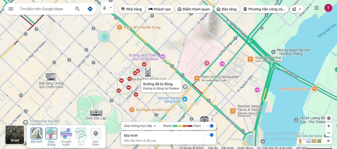
When you tap this icon, you will get a "Road Closed" message. You can zoom in on the map to see where the road closure is.
As for the mobile application, the map layer section is located in the upper left corner of the screen. With the same operation, you tap on traffic to see the prohibited routes.
The traffic section also displays traffic volume on the road by color. Therefore, you can know which routes are congested or which are clear and convenient for travel.
Accordingly, green represents fast traffic. Dark red represents slow traffic, there may be a traffic jam in this area.
Note for people during the 30/4 holiday
Use public transport: Due to limited parking in the restricted area, people are advised to use buses or metro (Ba Son station, City Theater, Ben Thanh) to travel.
Saigon River Tunnel: Motorcycles and motorbikes are allowed to pass through the tunnel from 11pm on April 22 and 25 to 1am on April 23 and 26, according to the instructions of the Traffic Police.
Watch live: People can watch the parade through 21 LED screens on central streets (Le Duan, Nam Ky Khoi Nghia, Nguyen Hue, etc.) or on VTV1, VOV1.
Tips to watch the 30/4 Festival in its entirety
To fully experience the April 30, 2025 parade:
Choose an ideal viewing location: Areas near Reunification Hall or LED screen installation locations such as in front of Ben Thanh Market, Nguyen Hue, Le Loi are good choices.
Check the parade route: The group departs from the intersection of Le Duan - Nguyen Binh Khiem at 6:30 am, dividing into 4 directions towards Tao Dan Park, Bach Dang Wharf, Hoa Lu Stadium, and Le Van Tam Park.
Avoid restricted areas: Use Google Maps or traffic apps to plan your route and avoid restricted roads.
Source: https://baonghean.vn/toan-bo-lich-ban-do-cam-duong-tai-tp-hcm-tu-ngay-22-4-23-4-25-4-26-4-27-4-28-4-30-4-phuc-vu-dai-le-30-4-10295961.html


![[Infographic] In 2025, 47 products will achieve national OCOP](https://vphoto.vietnam.vn/thumb/402x226/vietnam/resource/IMAGE/2025/7/16/5d672398b0744db3ab920e05db8e5b7d)


Comment (0)