
Rainfall exceeded 600mm.
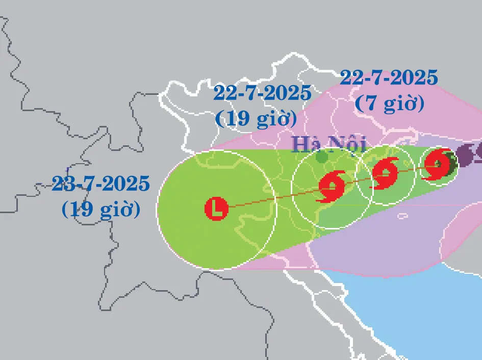
On the evening of July 21st, Typhoon No. 3 caused widespread strong winds in the Gulf of Tonkin. The Bach Long Vi Special Economic Zone experienced winds of force 8, gusting to force 9, while Co To and Cat Hai experienced winds of force 6, gusting to force 7. At this time, the typhoon's center was located at approximately 20.9 degrees North latitude and 108.7 degrees East longitude, just above the eastern part of the Gulf of Tonkin, about 100km from Quang Ninh, 220km from Hai Phong , 240km from Hung Yen, and 270km from Ninh Binh. Wind intensity at the center of the typhoon reached force 9 to 10, gusting to force 12. The main direction of movement was West-Southwest, with a speed of about 15km/hour.

The National Center for Hydro-Meteorological Forecasting of Vietnam, as well as international meteorological stations, predict that around noon on July 22nd, the storm's center will make landfall in Vietnam (with the heaviest winds concentrated along the northern coast). Coastal provinces in the North and North Central regions, especially Quang Ninh, Hai Phong, Hung Yen, Ninh Binh, and Thanh Hoa, will be within the storm's center and circulation. Heavy rain will continue until the end of July 23rd. The entire Northeast region, the Northern Delta, Thanh Hoa, and Nghe An will receive rainfall ranging from 200 to 350mm, with some areas exceeding 600mm. Other provinces in the North and Ha Tinh may experience rainfall exceeding 300mm in some areas. Some locations could receive up to 150mm of rain in just 3 hours, potentially causing sudden flash floods in the middle of the night.
On the afternoon of July 21st, Ms. Nguyen Thanh Binh from the National Center for Meteorological and Hydrological Forecasting stated that Typhoon No. 3 would not only cause heavy rain upon landfall but would also form a tropical convergence zone, resulting in prolonged rainfall for several days afterward. The northern mountainous provinces, Thanh Hoa, and Nghe An are warned as high-risk areas for flash floods and landslides, even after the typhoon subsides. Ms. Nguyen Thanh Binh warned: "Landslides can occur even after the rain stops, because the soil and rocks have been saturated with water for a long time."
Many areas have evacuated residents and banned maritime activities.
At noon on July 21st, Deputy Prime Minister Tran Hong Ha inspected storm prevention efforts at Ngoc Hai fishing port, Do Son ward (Hai Phong city). According to a report from Do Son ward, 100% of the vessels in the area had been moved to safe shelters. The total number of tourists staying in hotels and guesthouses was 1,335, including 55 foreign visitors.
The People's Committee of Hai Phong City stated that more than 6,600 households with over 19,700 people are living in areas at risk of landslides and need to be monitored and prepared for the storm's landfall. Deputy Prime Minister Tran Hong Ha instructed Hai Phong City to race against time and urgently evacuate people in dangerous areas, especially coastal areas, areas at risk of landslides, weak houses, and old apartment buildings.
In Hai Phong, on the afternoon of July 21st, Mr. Bui Xuan Hai, Deputy Director of the Hai Phong City Department of Construction, stated that the department had requested the People's Committees of communes, wards, and special zones to expedite inspections at ferry terminals. The People's Committee of the Cat Hai Special Zone has banned operations at the Gia Luan ferry terminal (connecting Tuan Chau Island with the Cat Hai Special Zone). The Hai Phong City Department of Construction has also directed management units to ban ferry operations at: An Thanh commune, Lai Xuan ferry (crossing the Da Bach River in Viet Khe commune), Duong Ao ferry (crossing the Van Uc River in Kien Hung and Hung Thang communes), and Dong Bai - Cai Vieng ferry (in the Cat Hai Special Zone). Within Hai Phong city, special bridges such as Hoang Van Thu, Dinh Vu - Cat Hai, Kien, and Binh bridges must prohibit vehicles and pedestrians during strong winds.
The Hai Phong City Military Command and Police Department mobilized more than 35,400 people to assist the public in responding to the storm. Hai Phong City leaders established an emergency Zalo group including all 114 chairmen of commune, ward, and special zone People's Committees, as well as leaders of departments and agencies, to provide direct and continuous guidance and coordination.
 assist people on floating rafts to move safely ashore. Photo: THU BAU")
In Quang Ninh province, Co To Special Economic Zone was identified as one of the locations directly affected by the storm. The Co To Special Economic Zone authorities notified 100% of accommodation establishments to allow tourists to leave the island proactively. By July 21st, the zone had organized 44 ferry trips, safely bringing over 8,800 tourists back to shore. Everywhere, preparations were underway to combat the storm: residents were cleaning up shops, moving water sports equipment ashore, dismantling signs, and reinforcing structures to minimize damage when the storm hit...
Given the complex developments of Typhoon No. 3, on July 21, the Ministry of Agriculture and Environment sent an urgent letter to the People's Committees of provinces and cities with ships operating in the Gulf of Tonkin, requesting them to mobilize all forces and resources to call upon, guide, or forcibly bring ships back to shore for safe anchorage.
The Ministry stated that by July 21st, six localities had issued bans on sea activities. Specifically, Quang Ninh banned fishing from 2 PM, Hai Phong from 5 PM, and Hung Yen from 6 PM on July 20th; Ninh Binh, Thanh Hoa, and Nghe An provinces also issued bans from the morning of July 21st. By the afternoon of July 21st, along the coastal strip from Quang Ninh to Ha Tinh, more than 29,000 fish cages, nearly 4,000 watchtowers, and nearly 150,000 hectares of aquaculture farms were at risk of being affected. Local authorities have requested the relocation of all fish cages and watchtowers to safe locations starting from July 21st.
Typhoon Wipha sweeps across China.
By late afternoon on July 21, Typhoon Wipha had weakened after sweeping through Guangdong Province, China. The Chinese National Meteorological Administration forecasts continued rain in coastal areas of Guangdong, Guangxi, Hainan, and Fujian until the morning of July 22. Earlier, according to the Global Times, 669,162 people across Guangdong Province had been evacuated, including 12,036 from offshore areas and 657,126 from inland areas. In Hong Kong, over 400 flights were canceled, affecting nearly 80,000 passengers; 26 people were hospitalized, and 471 trees were felled.
KHANH HUNG
Source: https://www.sggp.org.vn/trua-nay-bao-so-3-vao-dat-lien-post804803.html

![[Photo] National Assembly Chairman Tran Thanh Man working with the Standing Committee of the National Assembly's Delegation Affairs Committee.](https://vphoto.vietnam.vn/thumb/1200x675/vietnam/resource/IMAGE/2026/05/20/1779294340023_ndo_br_1-1691-jpg.webp)
![[Image] "Journey of Hope" promotes the organ and tissue donation movement in Vietnam.](https://vphoto.vietnam.vn/thumb/1200x675/vietnam/resource/IMAGE/2026/05/20/1779294400833_1-8910-jpg.webp)


![[Photo] General Secretary and President To Lam works with the Party Committee of the Ministry of Health on the work of Vietnamese traditional medicine.](https://vphoto.vietnam.vn/thumb/1200x675/vietnam/resource/IMAGE/2026/05/20/1779294323718_a1-bnd-2978-3319-jpg.webp)


Comment (0)