
The territory of Hoai Nhon Prefecture was established in the 2nd year of Hong Duc (1471), a rather large "remote region"; after more than 550 years, the initially large land was divided into many provinces in the South Central Coast and the North Central Highlands. The name was also changed according to the historical process, from Hoai Nhon Prefecture (1471) to Quy Nhon Prefecture (1602), Quy Ninh Prefecture (1651), taking back the old name Quy Nhon (1742), Binh Dinh Palace (1802), Binh Dinh Town (1809), Binh Dinh Province (1832) and currently Binh Dinh merged with Gia Lai Province and is called Gia Lai Province...
Let's review the important milestones on this journey.
1 .
According to the Dai Nam Nhat Thong Toan Do of 1834, with the description of Phan Huy Chu, we can understand the history of Hoai Nhon prefecture in the past. Hoai Nhon prefecture is located in the south of Quang Nam , bordering Ai Lao to the west, and the coast of Champa to the south. The previous dynasty erected a stele on the mountain as a boundary. When King Thanh Tong went to pacify Champa, he ordered the mountain stones to be ground to make a stele to mark the boundary.
>According to the Dai Nam Nhat Thong Toan Do in 1834, the Le Dynasty's concern was the North-South axis. The South was Champa, the North was the resistance to the invasion intentions of the Northern feudalism. During the reign of Lord Nguyen Hoang from 1558 to 1613, the primary concern was still the North-South axis; accordingly, the South was still a countermeasure to Champa, but the North was the opposition to the Trinh family. In the development of the Nguyen Lord's strategic position and power, the East and the West were basically favorable. The East Sea was a place for trade with foreign countries, creating a strong foundation for the economy . For the West, the mountainous region, the source of forestry and local product exports, so Lord Nguyen used conciliatory and flexible policies.
Hoai Nhon Palace, excerpt from “Hong Duc Map”. Photo: NTQ Document |
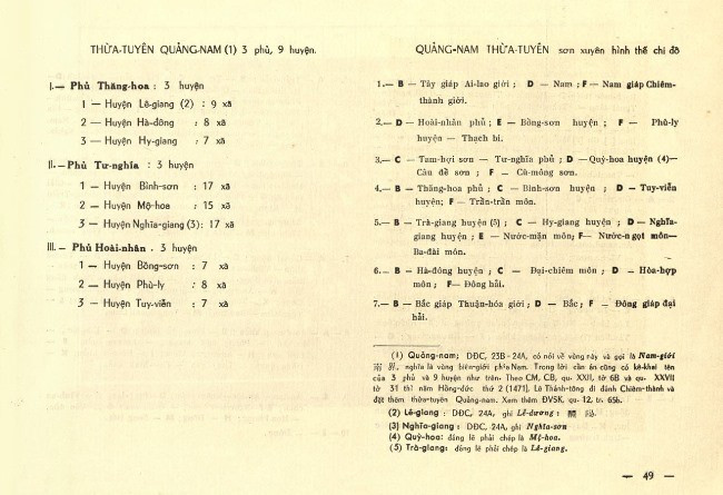
Thus, for 140 years, Hoai Nhon prefecture, later Quy Nhon prefecture (from the Le dynasty established Hoai Nhon prefecture in 1471 to the establishment of Phu Yen prefecture in 1611), with the role of a border area of Dai Viet, Hoai Nhon prefecture had the largest territorial limit among the 13 regions of Dai Viet at that time, including the coastal region and the central highlands, including the current Gia Lai province.
2.
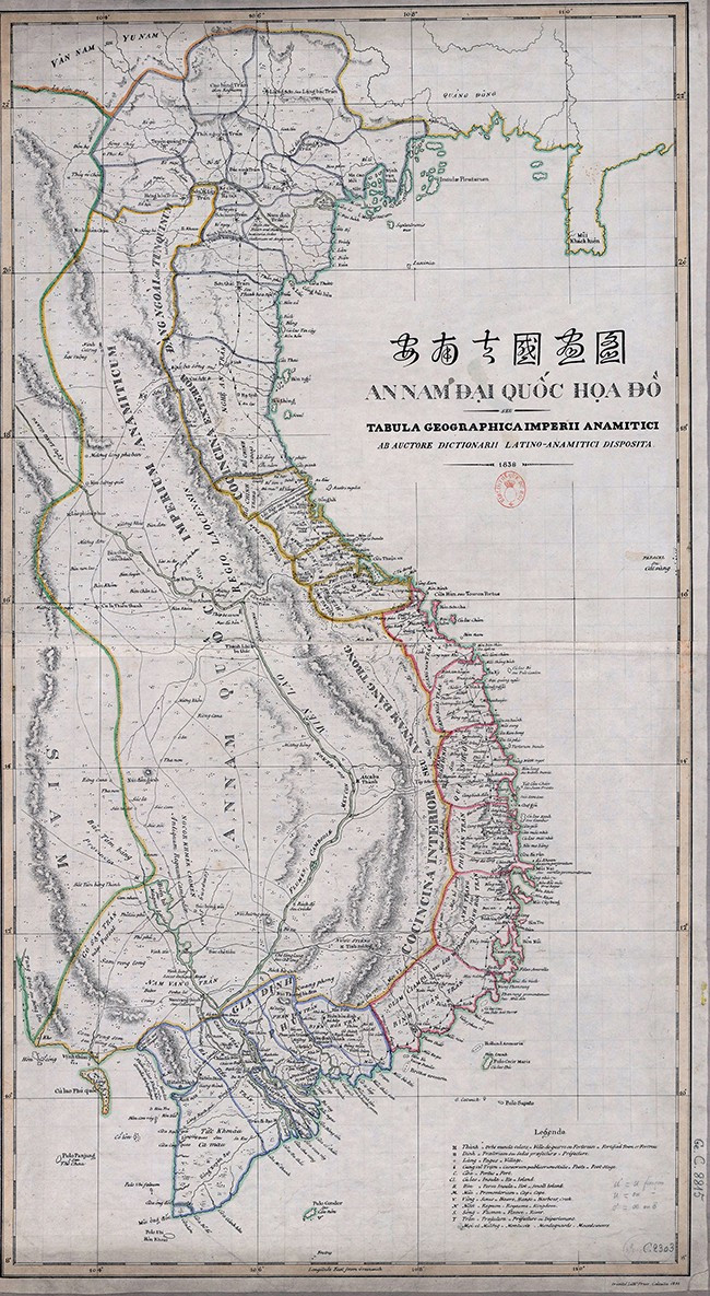
According to the Annam Dai Quoc Hoa Do by Tabert in 1838, we see that there are 2 borders: the Cocincina interior border of Annam Dang Trong; the Annam country border of Imperium Anamiticum, crossing the Mekong River to Thanom Don Ganh mountain. Through research on the land register of the Nguyen Dynasty, by the time of Minh Mang, the specific work was only at the beginning.
In the 30th year of Tu Duc (1877), An Khe office was established to manage 28 newly established villages on the banks of the Ba River. In the 3rd year of Dong Khanh (1888), An Khe office merged with a part of the western part of Tuy Vien district to form Binh Khe district, Binh Dinh province. According to the Treaty of Giap Than - 1884, France recognized the Central region as having the current Central Highlands. This was a complete region, at one time it was one but at other times it was divided into many provinces.
Map of An Nam Dai Quoc 1838. Photo: NTQ's documents |
In 1898, the French colonialists requested to take full administrative power and directly rule the ethnic minorities in the Central Highlands, and established an administrative agency in Kontum, which was directly under the Quy Nhon consulate.
In 1913, Kontum was separated into 3 agencies: Kontum Agency, Cheo Reo Agency, Daklak Agency. In 1923, Daklak Agency was separated from Kontum province, establishing Daklak province. In 1925, Pleiku Agency was established in Kontum province. In 1932, Pleiku Agency was separated to establish Pleiku province. Basically, it can be seen that the Kontum land separated from Binh Dinh formed three provinces: Kontum, Pleiku and Daklak.
3.
After the victory at Do Ban, on March 1, the second year of Hong Duc (1471), Dai Viet opened up its territory to Thach Bi mountain. King Le Thanh Tong appointed officials, organized a governing apparatus including both Cham and Vietnamese officials, and gave them great power: "If anyone refused to follow, they would be killed and reported later" (Complete Annals of Dai Viet) .
From then on, the Vietnamese people gradually moved in to settle in Hoai Nhon district from Cu Mong pass (the current Binh Dinh - Phu Yen border) outwards; from Cu Mong pass to Da Bia border (the current Phu Yen - Khanh Hoa border) was the buffer zone for the southern border land, although nominally the land of Dai Viet, it was still left for the Cham people and other ethnic groups to live.
The first residents who opened up the remote land - Hoai Nhon, in addition to the poor people who came to settle down, also had military forces and especially exiled criminals who were also recruited into the fighting and production forces in Hoai Nhon. Phan Huy Chu's book Lich Trieu Hien Chuong Loai Chi , recorded very clearly: "In April (the 5th year of Hong Duc - 1474), there was an edict that: Prisoners sentenced to exile, if they go to the near region, they will serve as guards of Thang Hoa (Quang Nam), if they go to the outside region, they will serve as guards of Tu Nghia (Quang Ngai), if they go to the far region, they will serve as guards of Hoai Nhon".
After a century of land reclamation, the Vietnamese people established villages in most of the land of Hoai Nhon district from the foot of Cu Mong pass outwards. In 1578, during the Le dynasty under Nguyen Hoang, Luong Van Chanh was appointed as Tuy Vien district chief "to pacify the border town and gather the scattered people to Cu Mong and Ba Dai, and reclaim the wasteland in Da Dien river" (Dai Nam Nhat Thong Chi) , this is the land of Song Cau, Tuy An and Tuy Hoa of Phu Yen province today.
Since 1578, Vietnamese people have come to settle on the other side of Cu Mong Pass, starting to eliminate the "buffer zone" of Le Thanh Tong's time. In 1611, two years before his death, Nguyen Hoang sent troops to officially reclaim all of Le Thanh Tong's land, which had been marked as the boundary to Da Bia, and established Phu Yen prefecture with two districts: Dong Xuan and Tuy Hoa.
In 1648, there was a large migration in the history of opening up the land to Quang Nam, when Lord Nguyen defeated the Trinh army and captured more than 30,000 prisoners. With a clear vision, Lord Nguyen Phuc Lan ordered the implementation: Currently, from Thang (Thang Binh), Dien (Dien Ban) to the South, all are Cham lands, sparsely populated, if we bring them to settle in that land, give them farming and land division into each department, each hamlet, calculate the population and give them food to reclaim the wasteland, then in a few years, the tax collected can help the country and after 20 years, the population will increase, we can add them to the army, there is nothing to worry about in the future.
In 1655, during the battle across Gianh River to attack Nghe An and occupy 7 districts south of Lam River, Lord Nguyen captured many prisoners of war and farmers from Nghe An and brought them to establish villages in Quy Ninh (Quy Nhon). Among them were the ancestors of the three Tay Son brothers. The book Dai Nam Chinh Bien Chronicle , volume 30, recorded: The ancestors of the Nguyen family in Tay Son land were originally from the Ho family, from "Hung Nguyen district - Nghe An, during the Thinh Duc era (1653-1657) of the Le dynasty, the 4th generation ancestor Nguyen Van Nhac was captured by our army (Lord Nguyen) and brought to live in Nhat ap in Tay Son region, Quy Ninh land (Quy Nhon)..." (Nhat ap: An Khe village, Nhi ap: Cuu An village).
From the war with Le - Trinh, Lord Nguyen had more manpower to reclaim land, establish villages and quickly build Hoai Nhon into a prosperous land, a place to gather talented people of Dang Trong and become a solid support of Lord Nguyen.
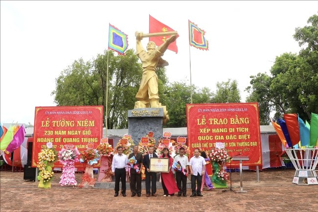
An Khe Town (Gia Lai) is honored to receive the Certificate of National Special Monument Complex ranking for "Tay Son Thuong Dao Complex" (August 2022). Photo: NGOC THU |
4.
Having to adapt to the natural environment and reclaim land for their own survival, the exiled criminals in the western region of Hoai Nhon quickly integrated with the local population. And naturally, they sought ways to escape the control of local officials. And so they moved deeper and deeper into the vast western mountains.
According to Associate Professor Diep Dinh Hoa, “For the Cay Dua people (the western region of Hoai Nhon prefecture), regions such as Indochina and Lower Laos are very close to them, not strange or scary. For the class of merchants who keep their reputation, their children and grandchildren go to the places where their fathers or grandfathers operated, and are accepted by the people to live and do business...”. People working in the trading system or military posts (formerly trading stations) are often chosen from the merchants (traders). Documents recorded in old history have many other ways of calling these people, such as: subordinates, clerks, interpreters..., most of them are from the Cay Dua area, Cau Bong source. During the Nguyen Dynasty, Cau Bong source (Phuong Kieu, An Khe) according to Le Quy Don was one of the 7 sources of Quy Nhon prefecture with the highest tax payment. Associate Professor Diep Dinh Hoa believes that through this trading route, there were quite a few Vietnamese people from Hoai Nhon/Quy Nhon prefecture who went to the Central Highlands to make a living at that time.
According to the History of the Gia Lai Provincial Party Committee, Gia Lai residents can be divided into two groups: The indigenous population that has lived in Gia Lai for a long time, including the Jrai and Bana ethnic groups, and the newly arrived population, mainly Vietnamese. The first Vietnamese people came to live in the An Khe area (formerly Hoai Nhon, present-day Gia Lai) from the end of the 17th century. Following this first group of people, the number of Vietnamese people from Binh Dinh region came to reclaim land and settle in An Khe, and the number of Vietnamese hamlets grew more and more next to the Bana and Jrai polei (villages).
However, until the early 19th century, the number of Vietnamese people settling in Gia Lai was still very small, concentrated mostly in the An Khe area. This group of residents lived mainly on farming and trading, exchanging goods with local ethnic minorities, most of whom came from Binh Dinh. In the inner city, the first Vietnamese village was Hoi Phu, founded by Mr. Nguyen Si (the owner of the tomb) from Xuan Yen village, Cat Tuong commune, Phu Cat district, Binh Dinh province. The tomb was established by nearly 20 families at the beginning of Le Lai street around 1905. The population grew, and later they separated to establish Hoi Thuong village. The next villages established in the North were: Tien Son, Ngo Son, Hien Son; in the East were: Phu Tho, Nguyen Loi, Quang Dinh, An My, Tra Nha; In addition, there were also Tra Da village (to the south of Bien Ho market today), Gia Tuong (to the east of Bau Can plantation), Tra Ba, Thanh Binh, Phu My, Phu Thach, Chau Khe, Phu Yen, La Son, Buu Son (according to the History of Pleiku City Party Committee ).
During the French colonial period, in the years 1923 - 1945, the colonial government brought a group of Vietnamese people from the coastal plains of Central Vietnam, mostly from Binh Dinh, to work as workers in tea and coffee plantations and road construction sites along National Highway 19.
From 1954 onwards, the Vietnamese population in Gia Lai increased rapidly, including many Binh Dinh people who were sent to plantation areas due to the forced migration policy of Ngo Dinh Diem's time and Binh Dinh people who fled to avoid the fierceness of the war.
Despite the difficulties and obstacles in terms of climate, weather, and disease, Binh Dinh migrants continued to move to Gia Lai to settle down through many historical periods. During that process, they brought with them their cultural elements and sought to integrate them with the local culture in the new environment, as well as quickly learned to ensure their long-term survival on the plateau. The factors of origin, ability to integrate, and blood connection mentioned above are very important points that the Party and State took into account when formulating the policy of merging the two provinces of Binh Dinh and Gia Lai today.
NGUYEN THANH QUANG
Source: https://baogialai.com.vn/tu-phu-hoai-nhon-den-tinh-gia-lai-post331097.html


![[Photo] National Assembly Chairman Tran Thanh Man visits Vietnamese Heroic Mother Ta Thi Tran](https://vphoto.vietnam.vn/thumb/1200x675/vietnam/resource/IMAGE/2025/7/20/765c0bd057dd44ad83ab89fe0255b783)


Comment (0)