
On the morning of July 21, the Ministry of Agriculture and Environment sent an official dispatch to the People's Committees of coastal provinces and cities of Hung Yen, Ninh Binh, Thanh Hoa, Nghe An, Ha Tinh, Quang Tri, Da Nang, and Quang Ngai requesting urgent mobilization of all forces and means to call on ships operating in the Gulf of Tonkin to seek safe shelter.
According to the report of the Border Guard's Civil Defense, Disaster Prevention and Search and Rescue Command, as of 6:30 a.m. on July 21, there were 425 ships/1,560 people operating in the Gulf of Tonkin (including the Hoang Sa archipelago), specifically as follows: Hung Yen 1 ship/10 people; Ninh Binh 137 ships/284 people; Thanh Hoa 27 ships/72 people; Nghe An 173 ships/675 people; Ha Tinh 9 ships/20 people; Quang Tri 27 ships/148 people; Da Nang 12 ships/77 people; Quang Ngai 39 ships/274 people.
The Ministry of Agriculture and Environment requests the People's Committees of provinces and cities to urgently mobilize all forces and means to call, guide or take coercive measures to bring the above-mentioned vessels to shore. The People's Committees of provinces and cities are fully responsible to the Prime Minister for ensuring the safety of vessels and strictly implementing the contents of Official Dispatch No. 117/CD-TTg dated July 20, 2025 of the Prime Minister.
The Ministry of Agriculture and Environment requests Vietnam Television, Voice of Vietnam, Vietnam News Agency, Coastal Information Station System and mass media agencies to immediately broadcast and report on the above-mentioned boats so that people, boat owners and local authorities know and promptly move to shore, ensuring safety of life and property.
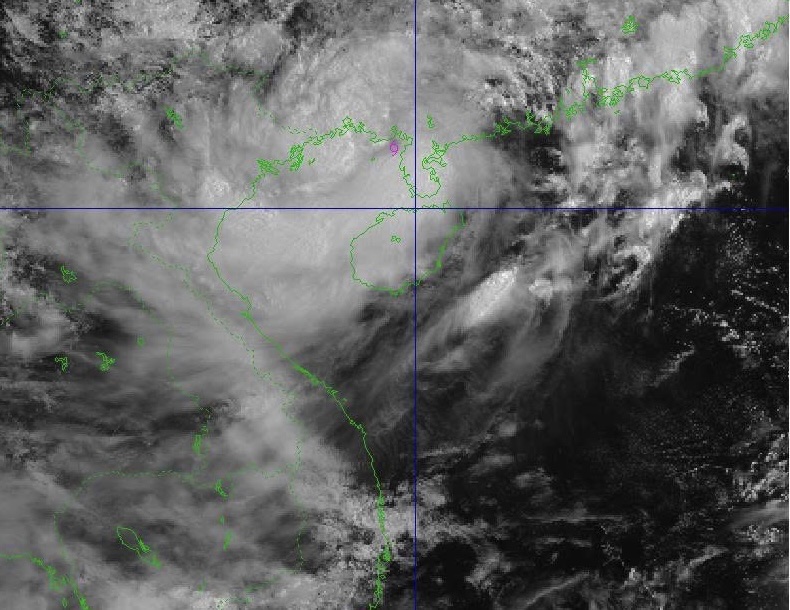
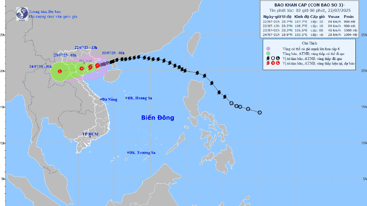
According to the National Center for Hydro-Meteorological Forecasting, at 10:00 a.m. this morning, the center of the storm was located at about 21.2 degrees North latitude; 109.6 degrees East longitude, about 340 km from Hung Yen and about 365 km East Northeast of Ninh Binh; more than 200 km from Quang Ninh-Hai Phong. Strongest wind: Level 9 (75-88 km/h), gusting to level 11. Forecast: In the next 3 hours, the storm will move in a West Southwest direction, at a speed of about 15 km/h.
Due to the influence of the storm, the northwestern sea area of the northern East Sea has strong winds of level 7-8, near the eye of the storm level 9, gusts of level 11; waves 4-6m high, very rough seas. The northern sea area of the Gulf of Tonkin (including the special zones of Bach Long Vi, Co To, Cat Hai, Hon Dau island) has strong winds of level 6-7, then increasing to level 8-9, near the eye of the storm level 10-11, gusts of level 14, waves 2-4m high, near the eye of the storm 3-5m, rough seas; the southern sea area of the Gulf of Tonkin (including Hon Ngu island) has winds gradually increasing to level 6-7, near the eye of the storm level 8-9, gusts of level 11, waves 2-4m high, very rough seas.
In addition, the coastal areas of Hai Phong-Quang Ninh have storm surges of 0.5-1m high. The water level at Hon Dau (Hai Phong) is 3.7-4.1m high, at Cua Ong (Quang Ninh) is 4.4-4.8m high and at Tra Co (Quang Ninh) is 3.6-4m high. There is a high risk of flooding in coastal areas and river mouths on the afternoon of July 22.
The meteorological agency warns that the weather at sea and in coastal areas during the storm is extremely dangerous and unsafe for any vehicles or structures operating in the danger zone such as cruise ships, passenger ships, cargo ships, cages, rafts, aquaculture areas, dykes, embankments, and coastal routes. Vehicles are at high risk of capsizing, destruction, and flooding due to strong winds, storms, whirlwinds, large waves, and rising sea levels.
From tonight, the coastal areas from Quang Ninh to Nghe An will have winds gradually increasing to level 7-9. On land, from the evening and night of July 21, the coastal areas from Quang Ninh to Nghe An will have winds gradually increasing to level 7-9, near the storm center level 10-11, gusting to level 14; inland areas, strong winds level 6, gusting to level 7-8. Winds of level 10-11 can knock down trees, electric poles, and rip off roofs, causing very heavy damage.
From July 21-23, the northeastern region, the Northern Delta, Thanh Hoa and Nghe An will have heavy to very heavy rain and thunderstorms with common rainfall of 200-350mm, locally over 600mm; other places in the Northern region and Ha Tinh will have moderate to heavy rain, locally very heavy rain and thunderstorms with common rainfall of 100-200mm, locally over 300mm. Warning of the risk of heavy rain (>150mm/3 hours). Heavy rain in a short period of time can cause flash floods, landslides in mountainous areas, and flooding in low-lying areas.
Source: https://cand.com.vn/Xa-hoi/ung-pho-bao-so-3-cac-tau-thuyen-khan-truong-vao-noi-tru-an-an-toan-i775433/


![[Photo] National Assembly Chairman Tran Thanh Man visits Vietnamese Heroic Mother Ta Thi Tran](https://vphoto.vietnam.vn/thumb/1200x675/vietnam/resource/IMAGE/2025/7/20/765c0bd057dd44ad83ab89fe0255b783)


Comment (0)