
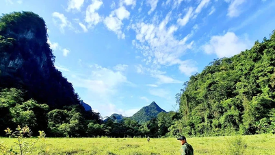
Many years ago, Fansipan was the ultimate goal for adventure tourists , as its 3,143m peak in the Hoang Lien Son mountain range, the "roof of Indochina," boasted one of the most rugged and dangerous terrains. At that time, only guided trails existed, filled with sheer cliffs, deep ravines, dense tropical forests, and unpredictable weather. With sudden sunshine and rain, the journey to Fansipan in the past was a major challenge for tour groups. From Sapa, there are three routes to the summit of Fansipan: Tram Ton, Sin Chai, and Cat Cat; each with its own unique characteristics, but all sharing one thing in common: this journey is not for those lacking stamina and the will to overcome challenges.

Later, the local authorities improved the road up the mountain from Tram Ton, saving tourists a lot of effort and time. No more sleeping in tents in the forest, no more worries about food and water shortages; the rest stops at altitudes of 2,200m and 2,900m now provide accommodation and meals for about 100 guests at a time. The Hmong porters are increasingly friendly and skilled in cooking, and the paved paths are wider and safer than before, with railings and ropes securing the steep slopes and wooden pegs to the rock face. The climb to Fansipan always welcomes everyone, and even though the cable car is now operational, hiking remains an irresistible experience.

Only by traveling like this, overcoming the challenges yourself, can you fully appreciate the beauty of nature here. The rhododendron carpets bloom in vibrant colors, towering trees occasionally drop pristine white petals, little-known wildflowers shyly bloom behind thick foliage, and then there are the patches of white clouds filling the sky, and the vast, green expanses that unexpectedly open up after a journey where only leaves obscured the view… And of course, reaching the highest peak in Indochina without relying on machinery will still be a great source of pride for everyone.

Not far from Fansipan, on the border between Lai Chau and Lao Cai provinces, lies Bach Moc Luong Tu mountain, which also attracts many tourists. At an altitude of 3,045m, this mountain is captivating due to its challenging terrain and stunning scenery. There are no standard paths; climbing requires following a trail, and of course, a local guide is still needed. Bringing their own tents, food, medicine, and medical supplies, climbing groups usually take 3 days and 2 nights, sometimes longer, to reach the summit and overcome the clouds. Extremely rugged but breathtaking, Bach Moc Luong Tu is an ideal cloud-hunting spot, a place where photographers can capture unforgettable images. The clouds here are ever-changing, like something out of a fairy tale – sometimes a vast expanse of fluffy white, sometimes a vibrant pink in the dawn light, and sometimes the sky takes on fantastical shapes.

Equally captivating is Pu Si Lung, located in Pa Ve Su commune, Muong Te district, Lai Chau province. Climbing groups usually gather in the village, then trek nearly 20km through the forest to reach border marker 42, known as the "roof of the border." The best way to navigate this route is with the guidance of soldiers from the Pa Ve Su border guard post. It's common to see young people draped in the national flag when standing by the border marker, a way of showing their love for the border region of the country. From there, a 6km trek through the mountains and forests is required to reach the summit of Pu Si Lung. That number might seem simple at first, but only by experiencing it firsthand can one truly understand the hardship. The mountain slopes, marked only by the footprints of forest trekkers, are slippery and very dangerous; the dense forests block sunlight; and the strange insects all test the willpower of each individual. After a few hours, the summit of Pu Si Lung will welcome visitors with a vast expanse of sky and clouds stretching endlessly, so close that it seems as if you could reach out and touch the blue sky.
Heritage Magazine


![[Image] Nearly 125,000 Hanoi students completed the Literature exam for the 10th grade entrance exam.](https://vphoto.vietnam.vn/thumb/1200x675/vietnam/resource/IMAGE/2026/05/30/1780117233041_ndo_br_thiet-ke-chua-co-ten-2-png.webp)


![[Image] Nearly 125,000 Hanoi students completed the Literature exam for the 10th grade entrance exam.](https://vphoto.vietnam.vn/thumb/402x226/vietnam/resource/IMAGE/2026/05/30/1780117233041_ndo_br_thiet-ke-chua-co-ten-2-png.webp)


![[Video] Sunset at Lap An Lagoon – Where the sun sets over the fishing nets](https://vphoto.vietnam.vn/thumb/800x450/vietnam/resource/IMAGE/2026/05/31/1780187239592_2222.jpeg)


![[Video] Sunset at Lap An Lagoon – Where the sun sets over the fishing nets](https://vphoto.vietnam.vn/thumb/402x226/vietnam/resource/IMAGE/2026/05/31/1780187239592_2222.jpeg)


Comment (0)