
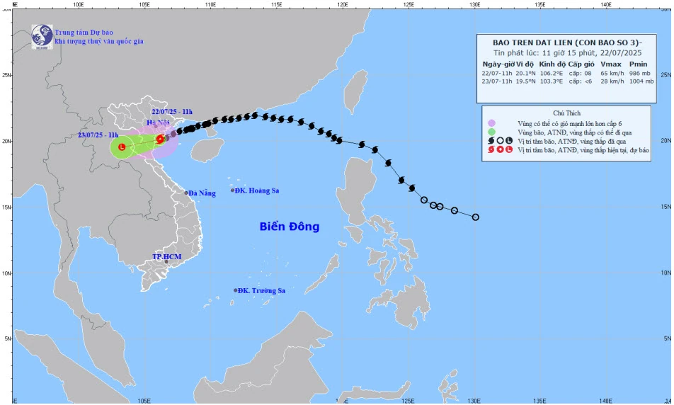
At around 7:00 a.m. on July 23, the center of the storm was at approximately 19.6 degrees North latitude; 103.8 degrees East longitude, in the Upper Laos region; wind intensity was less than level 6; moving in the West Southwest direction at a speed of about 10 - 15 km/hour and gradually weakening into a low pressure area.
Due to the impact of storm No. 3 and its circulation, from July 22 to 23, in the Northern Delta, Thanh Hoa and Nghe An, there will be heavy to very heavy rain and thunderstorms with common rainfall of 100 - 200 mm, locally over 300 mm. Other places in the Northern region and Ha Tinh will have moderate to heavy rain, locally very heavy rain and thunderstorms with common rainfall of 20 - 50 mm, locally over 100 mm. Heavy rainfall in a short period of time can cause flash floods, landslides in mountainous areas, and flooding in low-lying areas.
NDS
Source: https://baothanhhoa.vn/7-gio-sang-mai-23-7-bao-so-3-suy-yeu-thanh-ap-thap-nhiet-doi-gay-mua-lon-dien-rong-255721.htm


![[Photo] National Assembly Chairman attends the seminar "Building and operating an international financial center and recommendations for Vietnam"](https://vphoto.vietnam.vn/thumb/1200x675/vietnam/resource/IMAGE/2025/7/28/76393436936e457db31ec84433289f72)


Comment (0)