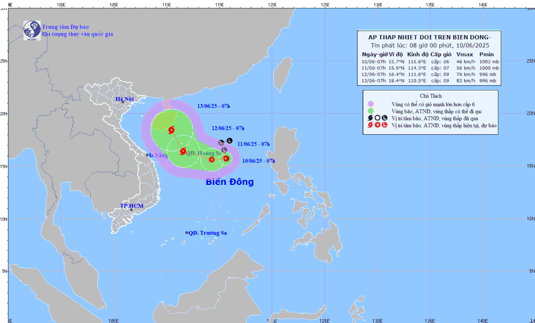
The path of the tropical depression in the East Sea on the morning of June 10
The National Center for Hydro-Meteorological Forecasting said that at 4:00 a.m. this morning, the center of the tropical depression was at about 15.7 degrees North latitude - 115.7 degrees East longitude, about 360 km East Southeast of Hoang Sa archipelago. The strongest wind in the center of the tropical depression reached level 6 (from 39-49 km/h), gusting to level 8. This cyclone system is moving slowly in a westerly direction, at a speed of about 5 km/h.
The tropical depression is likely to strengthen, reaching level 6-7 by 4am tomorrow, gusting to level 9, about 240km east-southeast of Hoang Sa archipelago.
By 4am on June 12, the tropical depression is likely to strengthen into a level 8-9 storm, gusting to level 11, over the Hoang Sa archipelago. The storm then turns west-northwest and speeds up to 10-15 km/h.
At 7:00 a.m. on June 12, the storm's center was located over the Hoang Sa archipelago, at approximately 16.4 degrees north latitude and 111.6 degrees east longitude. Winds were at level 8-9, gusting to level 11.
The danger zone extends from 13.5 to 18.5 degrees north latitude and from 109.5 to 117 degrees east longitude.
The disaster risk level remains at level 3, affecting the northern East Sea area, the northern area between the East Sea and offshore waters from Quang Tri to Quang Ngai .
It is forecasted that in the next 48 - 72 hours, the storm is likely to change direction, moving northwest at a speed of about 10 km/h and is likely to continue to strengthen.
Regarding the impact of the tropical depression, the North East Sea and the northern part of the central East Sea will have thunderstorms, strong winds of level 6 - 7, gusts of level 9; rough seas, waves 2 - 4m high. Ships in the dangerous area should be aware of the high risk of thunderstorms, tornadoes, strong winds and big waves.
Due to the influence of the tropical depression, the North East Sea and the North Central East Sea will have thunderstorms and strong winds of level 6-7, gusting to level 9, with waves 2-4 m high. Ships operating in the above-mentioned dangerous areas are likely to be affected by thunderstorms, whirlwinds, strong winds, and large waves.
On June 9, the Ministry of Agriculture and Environment requested coastal provinces of Quang Ninh - Kien Giang to closely monitor the development of the low pressure area that is likely to strengthen into a tropical depression and prepare response means.
The meteorological agency forecasts that from now until August 2025, storms and tropical depressions are likely to operate in the East Sea and affect Vietnam at a level approximately equal to the average of many years. There will be 5 storms in the East Sea and 2 storms will make landfall.
Thu Cuc
Source: https://baochinhphu.vn/ap-thap-nhiet-doi-co-the-manh-len-thanh-bao-so-1-vao-ngay-12-6-102250610092128074.htm













Comment (0)