
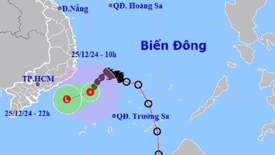
At 7am this morning, the tropical depression was about 290km from Da Nang and 210km from Quang Ngai, causing heavy rain in the North and Central Central regions for 3 days.
The National Center for Hydro-Meteorological Forecasting said the tropical depression's strongest wind speed is 49 km/h, level 6, gusting up two levels. In the coming hours, the tropical depression will head west at a speed of 10-15 km/h.
At 7 p.m., the tropical depression in the sea area of Da Nang reached Quang Ngai, with winds of about level 6-7, gusting to level 9. At about 4 a.m. tomorrow morning, after making landfall in the above area, the tropical depression will tilt north, affecting Thua Thien Hue and weakening into a low pressure area in the southern Laos region.
Forecast of the area affected by the tropical depression on the morning of September 25. Photo: NCHMF
The northern and central East Sea areas are experiencing thunderstorms and strong winds of level 6-7. The southern East Sea (including the waters of Truong Sa archipelago), and the waters from Binh Thuan to Ca Mau have strong southwest winds of level 6, gusting to level 7-8.
From this afternoon, the sea area from Quang Tri to Quang Ngai (including Con Co, Ly Son and Cu Lao Cham island districts) will have winds gradually increasing to level 6-7, with rough seas. By the evening, the wind in the Gulf of Tonkin will gradually increase to level 6, gusting to level 7-8.
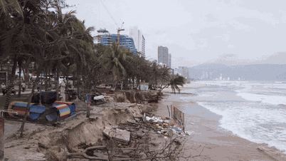
On land, from tonight to tomorrow morning, coastal areas from Quang Tri to Quang Nam and the north of Quang Ngai should be on guard for strong winds of level 6; further inland, gusts of level 6-7 should be expected.
From today until September 29, the tropical depression will cause heavy rain in the North and Central Central regions, with rainfall of 100-300 mm, in some places over 350 mm. The South Central, Central Highlands and Southern regions will have rain of 100-150 mm, in some places over 200 mm.
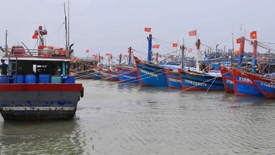
The National Steering Committee for Natural Disaster Prevention yesterday issued a telegram requesting provinces and cities from Quang Binh to Phu Yen to monitor the development of the tropical depression, manage and count vessels going out to sea, and notify ship owners of the direction of the tropical depression to escape the dangerous area.
Due to the influence of El Nino, Vietnam is forecast to be less affected by storms this year than in previous years. From the second half of August to November 2023, the East Sea is likely to see 5-7 storms and tropical depressions, of which 2-3 will directly affect the mainland.
Source link

![[Photo] Prime Minister Pham Minh Chinh receives Swedish Minister of International Development Cooperation and Foreign Trade](https://vphoto.vietnam.vn/thumb/1200x675/vietnam/resource/IMAGE/2025/5/12/ae50d0bb57584fd1bbe1cd77d9ad6d97)

![[Photo] Prime Minister Pham Minh Chinh starts construction of vital highway through Thai Binh and Nam Dinh](https://vphoto.vietnam.vn/thumb/1200x675/vietnam/resource/IMAGE/2025/5/12/52d98584ccea4c8dbf7c7f7484433af5)

![[Photo] Prime Minister Pham Minh Chinh works with the Standing Committee of Thai Binh Provincial Party Committee](https://vphoto.vietnam.vn/thumb/1200x675/vietnam/resource/IMAGE/2025/5/12/f514ab990c544e05a446f77bba59c7d1)


Comment (0)