
Forecast of the path of the tropical depression that could become storm number 15 of this year's rainy and stormy season - Photo: VNDMS
The storm is unlikely to reach far south.
Speaking with Tuoi Tre Online , Mr. Le Dinh Quyet, Head of the Forecast Department of the Southern Hydrometeorological Station, said that the continental cold high pressure is currently strengthening to the south.
The equatorial low pressure trough has an axis at about 4-7 degrees North latitude. Above, the subtropical high pressure has an axis over the Central region and is operating stably. The northeast wind is strong over the sea area of the Southeast region.
Commenting on the storm that is about to form, Mr. Quyet said that this storm could reach level 9-10 intensity, gusting to level 12, and the intensity will decrease as it moves closer to shore. The reason is because the current sea surface temperature is around 28 degrees Celsius, not too high, and the humidity according to altitude is also low.
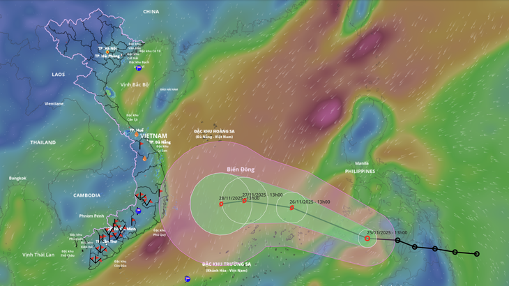
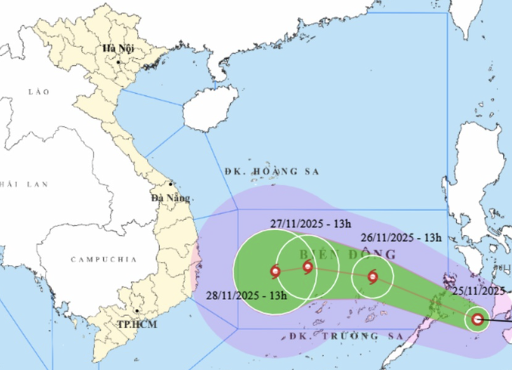
Regarding the trajectory, due to the strong northeast wind and the active low pressure trough in the South Central region, the storm will not have a high latitude trajectory and will have difficulty moving towards the South and Ho Chi Minh City.
Similarly, Ms. Le Thi Xuan Lan, a meteorologist, also said that according to the latest forecast from Japan, when the tropical depression strengthens into a storm in the East Sea, it will reach level 10, gusting to level 12. When it is about 100km from the shore, the storm's intensity will decrease.
"Tomorrow, November 26, when the storm is in the East Sea, the cold air from the north will still intensify quite strongly, but the storm is still far away because it has just passed the Philippines so it has not been affected yet. The storm is still moving west - northwest.
When the storm enters the northern part of the Truong Sa special zone, the cold air will make it change direction to the west-southwest. When it is near the shore, the cold air will weaken, making it difficult to push it down to the South like storm Durian. Both the American and Japanese models believe that the storm will move from Phu Yen to Khanh Hoa," Ms. Lan provided.
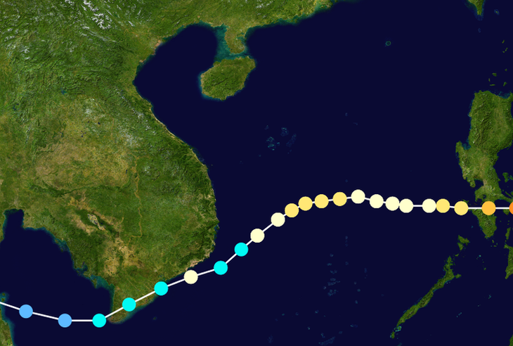
The path of the 2006 storm Durian and the path of the storm that is about to form - Photo: INT and NCHMF
Why is it difficult to repeat the Durian storm scenario?
According to Ms. Lan, two days ago, Japan thought the storm would move east of Con Dao and not make landfall, then weaken. But later, Japan said the storm would make landfall in Vietnam.
Recalling storm Durian, Ms. Lan said that storm was very strong, when it entered Truong Sa and Hoang Sa it reached level 14, gusting to level 15-16.
At that time, the initial forecast was that the storm would move into Ninh Thuan to old Binh Thuan. At that time, the cold air from the north was not too strong.
Surprisingly, the American model said that the sudden strong cold air will push the storm down, across Phu Quy Island into Ba Ria - Vung Tau and deep into the West.
And as predicted, the storm then changed direction suddenly, causing severe impacts on the South.
"As for the storm that is about to form, in addition to the forecast models of the US and Japan, I also looked at the long-term forecast to assess whether there will be a sudden strong cold front, but I think it will be difficult to happen. When the storm is about to make landfall, the cold front will be weak, so it will be difficult to change the storm's direction," Ms. Lan said.
But Ms. Lan noted that the amount of rain when the storm comes will have a big impact because the land in the South Central region is already soft and the hills are collapsing. People are still recovering from the storm. Storm Durian came when the above places were not affected before, but this storm came when there were only 2 floods so the danger is unpredictable.
However, Ms. Lan also warned that the weather will change a lot, people need to regularly monitor forecasts to have prevention and avoidance plans.
Source: https://tuoitre.vn/ap-thap-nhiet-doi-hien-tai-co-lap-lai-kich-ban-bao-durian-tung-do-bo-vao-tp-hcm-va-nam-bo-20251125152413041.htm


![[Photo] Prime Minister Pham Minh Chinh chairs the 15th meeting of the Central Emulation and Reward Council](/_next/image?url=https%3A%2F%2Fvphoto.vietnam.vn%2Fthumb%2F1200x675%2Fvietnam%2Fresource%2FIMAGE%2F2025%2F11%2F27%2F1764245150205_dsc-1922-jpg.webp&w=3840&q=75)

![[Photo] President Luong Cuong attends the 50th Anniversary of Laos National Day](/_next/image?url=https%3A%2F%2Fvphoto.vietnam.vn%2Fthumb%2F1200x675%2Fvietnam%2Fresource%2FIMAGE%2F2025%2F11%2F27%2F1764225638930_ndo_br_1-jpg.webp&w=3840&q=75)


![[Online forum] Effective implementation of ethnic policies in Thai Nguyen province](https://vphoto.vietnam.vn/thumb/402x226/vietnam/resource/IMAGE/2025/11/28/1764296450164_30729563efc1639f3ad0_20251128090933.jpeg)


Comment (0)