

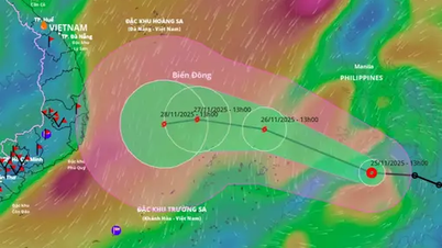
Chart of the path of the tropical depression near the East Sea at 2:00 p.m. on November 24 (photo from the National Center for Hydro-Meteorological Forecasting).
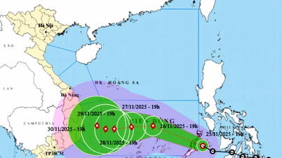
At 1:00 p.m. on November 25, the center of the tropical depression was at about 11.1 degrees north latitude; 121.7 degrees east longitude, in the central Philippines . The strongest wind near the center of the tropical depression was level 7 (50 - 61 km/h), gusting to level 9, moving west-northwest at a speed of about 20 - 25 km/h.
At 1:00 p.m. on November 26, the center of the tropical depression was at about 11.5 degrees north latitude; 117 degrees east longitude, on the northeastern coastal area of Truong Sa special zone, with the potential to strengthen into a storm, with the strongest wind near the center of the storm at level 8, gusting to level 10, moving west at a speed of about 20-25 km/h. The affected area includes the sea area east of the central and southern East Sea (including the sea area north of Truong Sa special zone).
In the next 48 - 72 hours, the storm will move mainly westward, about 15km per hour and continue to strengthen.
From the evening of November 25, the sea area east of the central and southern East Sea will have winds gradually increasing to level 6 - 7; near the storm center, winds will be level 8, gusting to level 10, waves 3 - 5m high, and rough seas.
Warning: Between the night of November 26 and 28, the central and southern areas of the East Sea (including the waters north of Truong Sa special zone) are likely to be affected by strong winds of level 9-10, gusting to level 13. Ships operating in the above-mentioned dangerous areas are likely to be affected by storms, whirlwinds, strong winds, and large waves.
Weather in An Giang : Cloudy, intermittent sunshine during the day, showers and thunderstorms in some places in the afternoon and evening. During thunderstorms, there is a possibility of tornadoes, lightning and strong gusts of wind.
Weather in An Giang coastal area: Cloudy to cloudy, sunny days with intermittent showers and thunderstorms in some places. Northeast wind level 4 - 5, sometimes gusting to level 6, wave height 1.5 - 2.25m, normal sea, sometimes slightly rough. During thunderstorms, beware of tornadoes and strong gusts of wind.
THUY TRANG
Source: https://baoangiang.com.vn/ap-thap-nhiet-doi-vao-bien-dong-co-kha-nang-manh-len-thanh-bao-so-15-a468169.html

![[Photo] Close-up of Ba Ha River Hydropower Plant operating to regulate water to downstream](/_next/image?url=https%3A%2F%2Fvphoto.vietnam.vn%2Fthumb%2F1200x675%2Fvietnam%2Fresource%2FIMAGE%2F2025%2F11%2F25%2F1764059721084_image-6486-jpg.webp&w=3840&q=75)


![[Photo] Prime Minister Pham Minh Chinh receives Governor of Gunma Prefecture (Japan) and Special Advisor to the Japan-Vietnam Friendship Parliamentary Alliance](/_next/image?url=https%3A%2F%2Fvphoto.vietnam.vn%2Fthumb%2F1200x675%2Fvietnam%2Fresource%2FIMAGE%2F2025%2F11%2F25%2F1764066321008_dsc-1312-jpg.webp&w=3840&q=75)


![[Answer] Should I install an elevator for an old renovated house?](https://vphoto.vietnam.vn/thumb/402x226/vietnam/resource/IMAGE/2025/11/25/1764039191595_co-nen-lap-thang-may-cho-nha-cai-tao-cu-khong-04.jpeg)


Comment (0)