
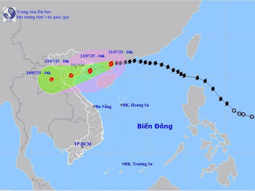
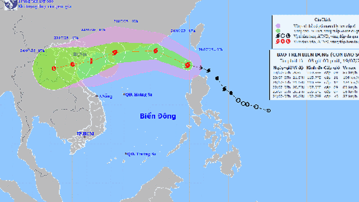
Path of storm No. 3. (Source: National Center for Hydro-Meteorological Forecasting)
According to the National Center for Hydro-Meteorological Forecasting, at 4:00 a.m. on July 21, the center of the storm was located at about 21.5 degrees North latitude; 110.4 degrees East longitude, in the northern area of Leizhou peninsula (China), about 275km east of Quang Ninh - Hai Phong .
The strongest wind is level 9, gusting to level 11. The storm is moving to the West Southwest, at a speed of 15-20 km/hour.
Storm forecast
Forecast until 4:00 a.m. on July 22, the storm will move in a West-Southwest direction, about 15km/h and is likely to strengthen; wind level 10 - 11, gust level 14.
The affected areas are the Northwestern sea area of the North East Sea, the North Gulf of Tonkin, and coastal waters of provinces from Quang Ninh to Hung Yen . Disaster risk level 3.
At 4:00 a.m. on July 23, the storm moved in the West Southwest direction at a speed of 10 - 15 km/hour and gradually weakened into a tropical depression, over the mainland of Hung Yen - Thanh Hoa provinces; wind speed level 6 - 7, gust level 9.
The affected areas are the Gulf of Tonkin and coastal areas of provinces from Quang Ninh to Nghe An. Disaster risk level 3.
At 4:00 a.m. on July 24, the storm moved in a West-Southwest direction, at a speed of 10-15 km/hour, gradually weakening into a low-pressure area over the mainland of Upper Laos.
The affected areas are the Gulf of Tonkin, coastal waters and mainland provinces from Quang Ninh to Nghe An. Disaster risk level 3.
On land, from the evening and night of July 21, the coastal area of Quang Ninh-Nghe An will gradually increase in strength to level 7-9, near the storm center level 10-11, gusting to level 14.
Deep inland, wind level 6, gusting to level 7 - 8. Wind level 10 - 11 can cause trees, electric poles, and roofs to fall.
Strong winds and big waves on the East Sea
On the morning of July 21, storm No. 3 made landfall in the southwest of Guangdong province (China), about 350km east of Quang Ninh - Hai Phong. The strongest wind was level 9, gusting to level 11.
Currently, in the Gulf of Tonkin, the North East Sea area (including Hoang Sa special zone), the sea area from Lam Dong to Ca Mau, Ca Mau to An Giang has showers and thunderstorms. Particularly, the sea area northwest of the North East Sea area has storms.
In Bach Long Vi special zone, there are gusts of level 8; in Phu Quy special zone, there are strong southwest winds of level 6, gusts of level 9 - 10; in Song Tu Tay station, there are gusts of level 7; in Huyen Tran station, there are strong winds of level 6, gusts of level 9.
Sea areas with scattered showers and thunderstorms, possibility of tornadoes and gusts of wind: Gulf of Tonkin, North East Sea area (including Hoang Sa special zone), sea areas from Lam Dong to Ca Mau, sea areas from Ca Mau to An Giang, Gulf of Thailand. During thunderstorms, there is a possibility of tornadoes and strong gusts of wind.
Forecast, day and night of July 21, the North Gulf of Tonkin (including the special zones of Bach Long Vi, Co To, Cat Hai, Hon Dau island) will have strong winds of level 6 - 7, then increasing to level 8 - 9, the area near the storm center will have level 10 - 12, gusting to level 15. The sea will be very rough. Waves will be 2 - 4m high, the area near the storm center will be 3 - 5m.
Southern Bac Bo Gulf (including Hon Ngu Island) has strong winds of level 6 - 7, near the storm center level 8 - 9, gusting to level 11. Very rough seas. Waves 2 - 4 m high.
In the North East Sea (including Hoang Sa special zone), the wind is at level 6, sometimes level 7, gusting to level 8 - 9, and the sea is rough. In the Northwest region, the wind is at level 7 - 8, and near the storm center, it is at level 9, gusting to level 11. The sea is very rough. Waves are 3 - 5m high, and near the storm center, they are 4 - 6m high.
Between the East Sea and the sea area from South Quang Tri to Khanh Hoa, there is wind level 6, sometimes level 7, gusting to level 8 - 9. Rough sea. West Southwest wind. Waves 2 - 5m high.
The northern sea area of the South China Sea (including Truong Sa special zone) and the sea area from Lam Dong to Ca Mau has wind level 6, gusting to level 7 - 8. Rough sea. Southwest wind. Waves 2 - 4m high.
Gulf of Thailand wind level 5, sometimes level 6, gusting to level 7 - 8. Rough sea. Southwest wind. Waves 1.5 - 3m high.
In addition, on the day and night of July 21, the Gulf of Tonkin, the North East Sea area (including Hoang Sa special zone), the sea area from Lam Dong to Ca Mau, Ca Mau to An Giang, the Gulf of Thailand will have showers and thunderstorms, especially the northwestern sea area of the North East Sea and the Gulf of Tonkin will have storms.
Level of disaster risk due to strong winds at sea: level 2, especially in the northwest sea area of the North East Sea and the Gulf of Tonkin, level 3.
All vessels operating in the above areas are at high risk of being affected by cyclones, strong winds and large waves.
Heavy rain in the North and North Central regions
Last night and early morning of July 21, in the Northeast, Northern Delta and Northwest regions, the area from Thanh Hoa to Quang Tri had scattered showers and thunderstorms, with heavy rain in some places.
Rainfall from 7pm on July 20 to 3am on July 21 was over 60mm in some places, such as: Thuan Chau station (Son La) 93.2mm, Quang Chieu 3 station (Thanh Hoa) 66.4mm, Huong Viet station (Quang Tri) 61.8mm...
From July 21 to the night of July 22, the Northeast, the Northern Delta, Thanh Hoa and Nghe An will have heavy to very heavy rain and thunderstorms with common rainfall of 170 - 280mm, some places over 450mm; other places in the North and Ha Tinh will have moderate rain, heavy rain, locally very heavy rain and thunderstorms with common rainfall of 80 - 160mm, some places over 250mm. Warning of the risk of heavy rain, some places over 150mm/3 hours. During thunderstorms, there is a possibility of tornadoes, lightning and strong gusts of wind.
In addition, on the day and night of July 21, the area from Quang Tri to Da Nang, the Central Highlands and the South will have scattered showers and thunderstorms, locally heavy rain with rainfall of 10-30mm, locally over 70mm. During thunderstorms, there is a possibility of tornadoes, lightning, hail and strong gusts of wind.
Flash flood and landslide warnings in many localities
From 0:00 to 3:00 on July 21, the provinces of Dien Bien, Son La and Quang Tri had moderate and heavy rain such as Song Da 53.8mm (Dien Bien); Thuan Chau 52.6mm (Son La); Truong Son 44mm (Quang Tri)...
On the morning of July 21, the above provinces continued to have rain with accumulated rainfall ranging from 20 - 40mm, in some places over 60mm.
Therefore, there is a risk of flash floods on small rivers and streams, landslides on steep slopes in the above provinces, especially in the communes/wards: Muong Tung, Muong Lay Ward, Sin Chai, Sinh Phinh, Tua Thang (Dien Bien); Binh Thuan, Chieng Hac, Chieng La, Long He, Long Phieng, Long Sap, Muong Chien, Muong Gion, Nam Lau, Phieng Khoai, Quynh Nhai, Thuan Chau (Son La); Kim Ngan, Truong Son; Dan Hoa, Huong Lap, Huong Phung, Kim Dien, Kim Phu, Thuong Trach (Quang Tri).
Flash floods and landslides can have very negative impacts on the environment, threaten people's lives; cause local traffic congestion, affect the movement of vehicles; destroy civil and economic works, causing damage to production and socio-economic activities.
Weather in regions across the countryHanoi capital
- Cloudy, heavy to very heavy rain with thunderstorms. Northwest wind level 2 - 3, later increasing to level 45. Thunderstorms have the possibility of tornadoes, lightning, hail and strong gusts of wind.
- Temperature ranges from 23 - 25 degrees Celsius, highest from 27 - 29 degrees Celsius.
Northwest region
- Heavy rain and thunderstorms over a wide area. West to Northwest winds level 2 - 3. Warning of tornadoes, lightning, hail and strong gusts of wind during thunderstorms.
- Lowest temperature from 23 - 26 degrees Celsius, some places below 23 degrees; highest from 28 - 31 degrees Celsius, some places above 31 degrees Celsius.
Northeast region
- The weather is also cloudy, with heavy to very heavy rain and thunderstorms. Northwest wind level 2 - 3, then increasing to level 4 - 5; in coastal areas from the evening and night, the wind gradually increases to level 6 - 9, gusting to level 10 - 11. High risk of tornadoes, lightning, hail and strong gusts.
- Temperature from 22 - 25 degrees Celsius, highest 26 - 29 degrees Celsius, some places over 30 degrees Celsius.
Area from Thanh Hoa to Hue
- In the North, there will be heavy to very heavy rain and thunderstorms; in the South, there will be scattered showers and thunderstorms, with some heavy rain in some places. West to Southwest wind level 2 - 4, especially in the North coastal area, the wind will gradually increase to level 4 - 5, gusting to level 7 - 8. Warning of dangerous weather phenomena such as tornadoes, lightning, hail and strong gusts of wind.
- Temperature from 23 - 26 degrees Celsius, highest from 29 - 32 degrees Celsius.
South Central Coast
- Sunny during the day, showers and thunderstorms in some places in the late afternoon and night. Southwest wind level 2 - 4. During thunderstorms, tornadoes, lightning, hail and strong gusts of wind may occur.
- Temperature from 26 - 29 degrees Celsius, highest from 31 - 34 degrees Celsius, some places above 34 degrees Celsius.
Central Highlands
- There will be scattered showers and thunderstorms in some places, especially in the afternoon and evening, with scattered showers and thunderstorms, with some heavy rain in some places. Southwest wind level 2 - 4. Warning of tornadoes, lightning and strong gusts of wind in thunderstorms.
- Temperature ranges from 20 - 23 degrees Celsius, highest from 25 - 28 degrees Celsius, some places above 28 degrees Celsius.
Southern Vietnam
- Cloudy, with scattered showers and thunderstorms, concentrated in the afternoon and evening. Heavy rain may occur in some places. Southwest wind level 2 - 3. During thunderstorms, beware of tornadoes, lightning and strong gusts of wind.
- Temperature from 24 - 27 degrees Celsius, highest from 29 - 32 degrees Celsius, some places above 32 degrees Celsius.
Ho Chi Minh City
- Cloudy weather, sunny during the day, scattered showers and thunderstorms in the afternoon and evening, locally heavy rain. Southwest wind level 3. Warning of tornadoes, lightning and strong gusts of wind in thunderstorms.
- Temperature ranges from 24 - 26 degrees Celsius, highest from 30 - 32 degrees Celsius.
According to VNA/Vietnam+
Source: https://baoquangtri.vn/bao-di-chuyen-theo-huong-tay-tay-nam-cach-quang-ninh-hai-phong-khoang-275km-196027.htm


![[Photo] National Assembly Chairman Tran Thanh Man visits Vietnamese Heroic Mother Ta Thi Tran](https://vphoto.vietnam.vn/thumb/1200x675/vietnam/resource/IMAGE/2025/7/20/765c0bd057dd44ad83ab89fe0255b783)


Comment (0)