
The National Center for Hydro-Meteorological Forecasting informed that at 10:00 a.m. this morning (October 22), storm No. 12 was at about 17.1 degrees North latitude; 110.7 degrees East longitude, about 260km East Northeast of Da Nang City. The strongest wind near the storm center is level 10 (89-102 km/h), gusting to level 12. Moving West Southwest, speed about 10 km/h.
Today, October 22, storm Fengshen moves in a West Southwest direction, traveling 10-15km per hour and weakens into a tropical depression.
By early tomorrow morning (October 23), the tropical depression will be at about 15.9 degrees North latitude - 108.6 degrees East longitude, in the coastal area of Hue - Quang Ngai ; the intensity of the tropical depression is currently at about level 7, gusting to level 9. After entering the Hue - Quang Ngai area, the tropical depression will continue to weaken, moving further inland and into the Southern Laos area.
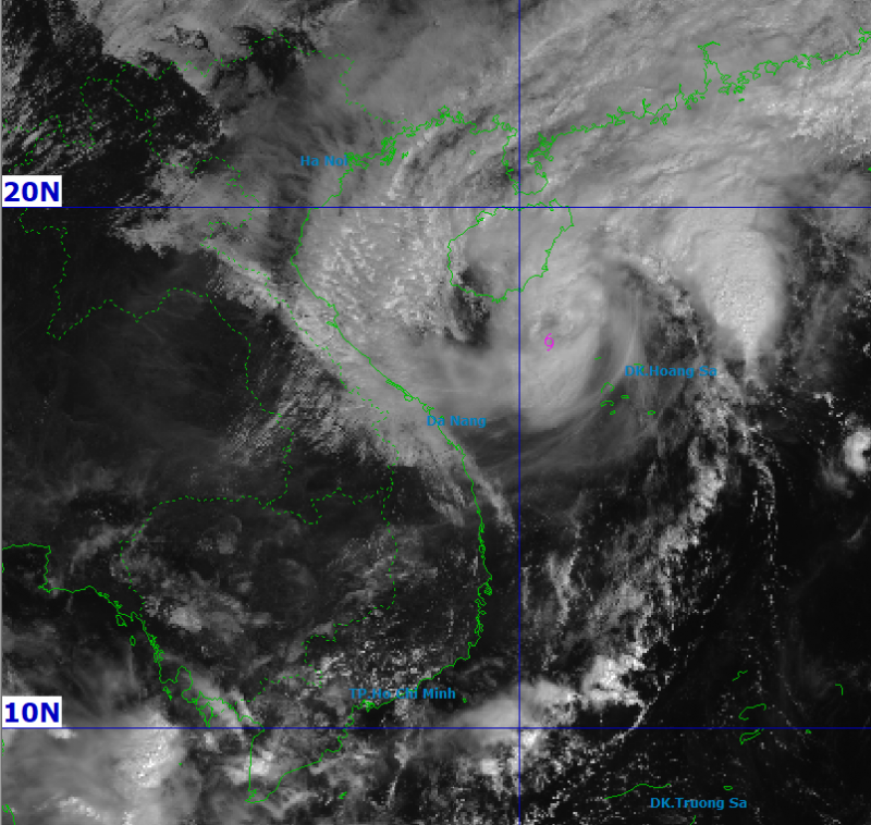
At sea, due to the influence of storm Fengshen, the northwest sea area of the East Sea (including Hoang Sa) has strong winds of level 7-8; near the storm center level 9-10, gusting to level 12; waves 3.0-5.0 m high, 5.0-7.0 m near the storm center, very rough seas.
The northeast wind in the Da Nang sea area is strong at level 6, gradually increasing to level 7 on the morning of October 22, gusting to level 8-9; near the storm center, level 8, gusting to level 10; waves 3.0-5.0 m high, rough seas. Storm surge along the coast of Da Nang is 0.4-0.8 m high.
Warning to all vessels in the danger zone affected by storms, whirlwinds, strong winds, and big waves. Coastal areas of Da Nang need to be on guard against big waves, high tides, and rising water causing flooding and coastal erosion.
On land, from October 22, coastal areas of Da Nang (Hai Chau, Hoa Khanh, Son Tra, Ngu Hanh Son, Hoi An, Dien Ban, Thang Binh, Tam Ky, Nui Thanh) will have winds gradually increasing to level 6, sometimes level 7, gusting to level 8-9.
From the afternoon of October 22-27, Da Nang is likely to have widespread heavy rain lasting for many days. Total rainfall in the areas of Hai Van, Hoa Khanh, Hai Chau, Cam Le, Son Tra, Ngu Hanh Son, Hoi An, Hoa Tien, Dien Ban, Dai Loc: 500-700 mm, some places over 900 mm. Thang Binh, Tam Ky, Nui Thanh areas: 450-650 mm, some places over 800 mm; Dong Giang, Tay Giang, Thanh My areas: 200-400 mm, some places over 500 mm; Que Son, Tien Phuoc, Kham Duc, Tra My areas: 500-700 mm, some places over 850 mm. The Center for Hydrometeorological Forecasting noted that heavy rain in this area could last until the end of October.
There is a high risk of flash floods, landslides in mountainous areas, and flooding in low-lying and urban areas. The risk of natural disasters due to floods and inundations is forecast at level 2-3. In addition, it is necessary to be on guard against the possibility of thunderstorms, tornadoes, and strong gusts of wind in the storm's circulation area, both before and during the storm's landfall.
Source: https://cand.com.vn/doi-song/bao-fengshen-cach-da-nang-260km-mua-lon-keo-dai-i785402/
![[Photo] Award Ceremony of the Political Contest on Protecting the Party's Ideological Foundation](https://vphoto.vietnam.vn/thumb/1200x675/vietnam/resource/IMAGE/2025/10/22/1761151665557_giaia-jpg.webp)


![[Photo] Prime Minister Pham Minh Chinh chairs meeting on nuclear power plant construction](https://vphoto.vietnam.vn/thumb/1200x675/vietnam/resource/IMAGE/2025/10/22/1761137852450_dsc-9299-jpg.webp)
![[Photo] Da Nang: Shock forces protect people's lives and property from natural disasters](https://vphoto.vietnam.vn/thumb/1200x675/vietnam/resource/IMAGE/2025/10/22/1761145662726_ndo_tr_z7144555003331-7912dd3d47479764c3df11043a705f22-3095-jpg.webp)


Comment (0)