
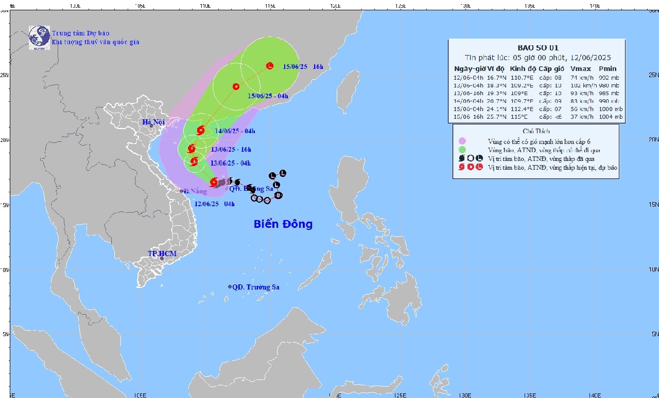
According to the National Center for Hydro-Meteorological Forecasting, the strongest wind near the storm's center is level 8 - 9 (62 - 88 km/h), gusting to level 11.
It is forecasted that in the next 24 hours (from 4:00 a.m. on June 12), the storm will move northwest at a speed of about 10 km/h and continue to strengthen. At about 4:00 p.m. on June 13, the storm center will be on the southern coastal area of Hainan Island (China) with a strong intensity of level 10, gusting to level 13. At 4:00 a.m. on June 14, the storm center will be on the eastern sea of the Gulf of Tonkin with a strength of level 9-10, gusting to level 12.
By June 15, the storm gradually weakened to level 7, gusting to level 9. After that, the storm moved northeast at a speed of 20 - 25 km/h and weakened into a tropical depression in the next 72 - 84 hours.
Under the impact of storm No. 1, the Northwestern East Sea, including the Hoang Sa sea area and the sea off the coast of the provinces from Quang Tri to Quang Ngai , is experiencing strong winds of level 6 - 8, near the storm center level 9 - 10, gusting to level 13. Waves are 3 - 5m high, especially near the storm center can reach 4.0 - 6m; very rough seas.
From the night of June 12, the Gulf of Tonkin will be directly affected by strong winds of level 6-7, near the storm center level 8-9, gusting to level 11. Waves from 2 to 4m high, risk of tornadoes and extremely strong gusts.
The National Center for Hydro-Meteorological Forecasting recommends that boats, especially fishing boats and tourist vehicles, absolutely do not move into dangerous areas.
It is forecasted that in the next 24 - 48 hours, the Central Central region will continue to have very heavy rain, with total rainfall ranging from 100 - 200mm, some places exceeding 350mm. In Ha Tinh and the Northern Central Highlands, there will be moderate to heavy rain with rainfall of 30 - 80mm, locally over 150mm.
The meteorological agency warned of the risk of flash floods and landslides in mountainous areas and urban flooding in low-lying areas.
According to VOV
Source: https://baothanhhoa.vn/bao-so-1-dang-manh-len-cap-10-giat-cap-13-251827.htm


Comment (0)