
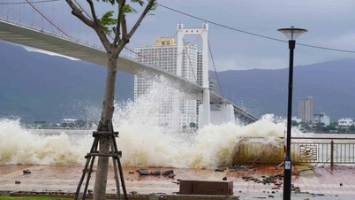
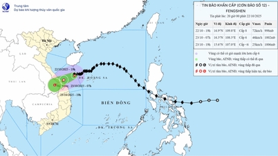
Rainfall and river water levels are at safe levels, total rainfall recorded up to 4:30 p.m. on October 22 is generally below 15mm; some places have higher rainfall such as Suoi Luong 129.6mm, Hai Van 80.4mm. Water levels on rivers in the city fluctuate at level below alert 1, especially the downstream of Vu Gia - Thu Bon river is at level above alert 1.
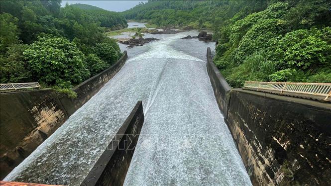
Reservoirs in the city and surrounding areas are operating normally. Of these, 17 are managed by Quang Nam Irrigation Exploitation Company Limited, 7 are full (Khe Tan, Thach Ban, Phu Loc, Huong Mao, An Long, Da Vach, Phuoc Ha); 7 are at 50-80% capacity; the remaining 3 are below 50%.
Regarding the lakes managed by Da Nang Irrigation Exploitation Company Limited, Hoa Trung Lake is full of water, Dong Nghe Lake has a water level of 31m, 2.3m below the normal level. Medium and small reservoirs in the area are basically full of water.
Of the 56 lakes managed by the locality (in the former Quang Nam province), 25 are currently full, the remaining are 1-4m below overflow. All hydroelectric reservoirs have lowered their water levels to accommodate the flood.
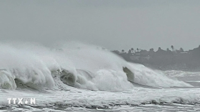
As of the afternoon of October 22, the city had 4,148 fishing boats with more than 21,000 workers. Of these, only 99 boats with 3,324 workers were still operating at sea, mainly in the Truong Sa (71 boats) and Hoang Sa (26 boats) areas, all of which had moved out of the storm's affected area. No boats were operating in the danger zone.
Local seaports such as Ky Ha port, Da Nang Port Border Gate port have a total of more than 100 cargo ships, oil tankers and transport ships safely anchored.
According to reports from the People's Committees of localities in Da Nang city, the evacuation of people was carried out promptly. In Tra Linh commune, the authorities urgently evacuated 8 households with 34 people in Konpin village, hamlet 2 to a safe place due to the impact of landslides. The locality has made plans to evacuate all 29 households in the high-risk area before heavy rains continue to occur.
In Hoi An Dong ward, the locality has implemented an on-site evacuation plan with 410 households, equivalent to 1,437 people, ready to move when requested.
Meanwhile, in Tay Giang commune, the section of DT.606 through Km23+454 to Km23+497 has a landslide, the roadbed has sunk about 43m long. The local authorities have put up warning signs, informing people to be proactive when traveling through this area.
To ensure traffic safety during the impact of storm No. 12 and prolonged heavy rain, the Department of Construction of Da Nang City recommends that vehicle owners limit traffic on National Highway 14D. The reason is that National Highway 14D is currently very severely damaged, many locations are muddy and sinking, causing difficulties in driving and traffic safety risks. Transport businesses with vehicles regularly traveling on National Highway 14D should pay attention to the recommendations to ensure safety for people and minimize property damage.
Source: https://baotintuc.vn/van-de-quan-tam/bao-so-12-cac-ho-thuy-loi-thuy-dien-o-da-nang-van-hanh-binh-thuong-dam-bao-an-toan-san-xuat-nong-nghiep-20251022201655702.htm


![[Photo] Award Ceremony of the Political Contest on Protecting the Party's Ideological Foundation](https://vphoto.vietnam.vn/thumb/1200x675/vietnam/resource/IMAGE/2025/10/22/1761151665557_giaia-jpg.webp)
![[Photo] Da Nang: Shock forces protect people's lives and property from natural disasters](https://vphoto.vietnam.vn/thumb/1200x675/vietnam/resource/IMAGE/2025/10/22/1761145662726_ndo_tr_z7144555003331-7912dd3d47479764c3df11043a705f22-3095-jpg.webp)

![[Photo] Prime Minister Pham Minh Chinh chairs meeting on nuclear power plant construction](https://vphoto.vietnam.vn/thumb/1200x675/vietnam/resource/IMAGE/2025/10/22/1761137852450_dsc-9299-jpg.webp)


Comment (0)