
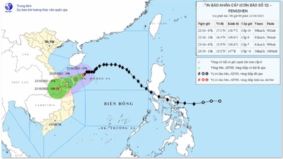
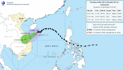
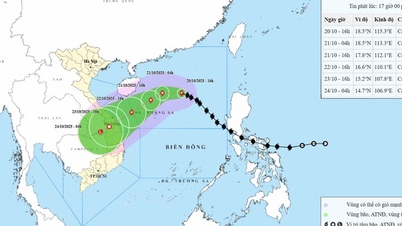
According to the National Center for Hydro-Meteorological Forecasting, at 5:00 a.m. today, October 22, the center of storm No. 12 was located at about 17.1 degrees North latitude and 110.8 degrees East longitude, about 290km East Northeast of Da Nang City. The strongest wind near the center of the storm reached level 10 (89-102km/h), gusting to level 12.

The National Center for Hydro-Meteorological Forecasting predicts that in the next 3 hours, the storm will move west-southwest at a speed of about 10km/hour. The storm is currently slowing down.
According to the forecast model of the National Center for Hydro-Meteorological Forecasting, around dawn tomorrow, October 23, the storm will be located in the coastal area from Hue to Quang Ngai , the center of the storm will head towards Da Nang city and will tend to gradually weaken into a tropical depression.
Vietnam's Meteorological Agency said that this morning, the western sea area of the North East Sea, including the Hoang Sa archipelago, has strong winds of level 7-8; the area near the storm's eye has strong winds of level 9-10, gusting to level 12.
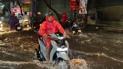
The sea area from Quang Tri to Quang Ngai, including Con Co, Cu Lao Cham and Ly Son, has strong winds of level 6-7; the area near the storm center has level 8, gusts of level 10, and rough seas. The coast from Quang Tri to Da Nang city has storm surges. All vessels operating in this area are at risk of being affected by thunderstorms, whirlwinds, strong winds and big waves. Coastal areas and river mouths from Quang Tri to Da Nang need to be on guard against big waves combined with high tides and rising water causing flooding in low-lying areas, affecting coastal traffic and risking coastal landslides.
The meteorological agency continues to warn of the risk of rain and floods during and after this storm. According to Mr. Mai Van Khiem, Director of the National Center for Hydro-Meteorological Forecasting, the storm circulation combined with cold air and high-altitude easterly winds will cause widespread heavy rain in the Central region (from Ha Tinh to Quang Ngai, heavy rain concentrated in the area from South Quang Tri to Da Nang, some places over 900mm, commonly from 500-700mm).
Source: https://www.sggp.org.vn/bao-so-12-huong-vao-khu-vuc-tu-hue-den-quang-ngai-post819245.html

![[Photo] Da Nang residents "hunt for photos" of big waves at the mouth of the Han River](https://vphoto.vietnam.vn/thumb/1200x675/vietnam/resource/IMAGE/2025/10/21/1761043632309_ndo_br_11-jpg.webp)

![[Photo] Prime Minister Pham Minh Chinh received Mr. Yamamoto Ichita, Governor of Gunma Province (Japan)](https://vphoto.vietnam.vn/thumb/1200x675/vietnam/resource/IMAGE/2025/10/21/1761032833411_dsc-8867-jpg.webp)


![[Photo] Prime Minister Pham Minh Chinh meets with Speaker of the Hungarian National Assembly Kover Laszlo](https://vphoto.vietnam.vn/thumb/1200x675/vietnam/resource/IMAGE/2025/10/20/1760970413415_dsc-8111-jpg.webp)


Comment (0)