
Specifically, in the early morning of November 27, the eye of the storm was about 190km north of Song Tu Tay Island. The strongest wind near the eye of the storm was level 12 (118-133km/h), gusting to level 15. Moving in the West Northwest direction, speed about 15km/h.
It is forecasted that by dawn tomorrow (November 28), the storm will slow down to a speed of 5-10km/h in the western sea area of the Central East Sea, about 190km northwest of Song Tu Tay Island. Wind force is level 12, gusting to level 15.
By dawn on November 29, the storm was moving west-northwest, then northwest, at a slow speed of about 5km/h in the western waters of the central East Sea. At this time, the wind was at level 11, gusting to level 14.
By dawn on November 30, the storm was moving at a speed of 3-5km/h in the western sea area of the Central East Sea. Winds were at level 10, gusting to level 13.
In the following hours, the storm moved slowly to the Northwest, then changed direction to the West Northwest, speed of 3-5km/h and gradually weakened.
The National Center for Hydro-Meteorological Forecasting warns that the Central East Sea area (including the sea area north of Truong Sa special zone) will have strong winds of level 7-9; the area near the storm's eye will have strong winds of level 10-12, gusting to level 15; waves 4.0-6.0m high, the area near the storm's eye will have waves of 7.0-9.0m; the sea will be very rough.
Note, vessels operating in the above mentioned dangerous areas are susceptible to the impact of storms, whirlwinds, strong winds and large waves.
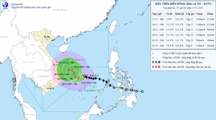
Forecast map of storm No. 15's trajectory and intensity released at 5:00 a.m. on November 27
Mr. Hoang Phuc Lam - Deputy Director of the National Center for Hydro-Meteorological Forecasting said that the next developments of storm No. 15 still have high dispersion among international hydro-meteorological models and agencies.
It is forecasted that from now until November 28, storm No. 15 will move in the West Northwest direction, then move mainly in the West direction at a speed of about 20km/h; from November 28, when the storm moves close to the 113th meridian, the subtropical high pressure will weaken, a low pressure trough will appear in the West wind zone at an altitude of 5,000m, which is likely to change the direction of the storm and there are different possibilities regarding the path and impact of storm No. 15 on the sea areas as well as the mainland of Vietnam.
In which, scenario 1, with the highest possibility currently, the storm changes direction to the North when reaching the Northwestern sea of Truong Sa special zone (about 500km east of the Gia Lai - Khanh Hoa coast (probability 80%): When the storm moves to the 113E meridian, the storm changes direction to the North, weakens into a low pressure area, then this low pressure area is likely to drift towards the mainland of the Central provinces, weakening at sea
Regarding strong winds at sea, the sea area east of the Central East Sea will have winds gradually increasing to level 6-7; the area near the storm center will have strong winds of level 8-9, gusts of level 11, waves 4.0-6.0m high, very rough seas. From November 27, the Central East Sea area (including the sea area north of Truong Sa special zone) is likely to be affected by strong winds of level 10-11, gusts of level 14, waves 6.0-8.0m high, rough seas.
Strong winds on land, low possibility of storms. The area from Da Nang to Lam Dong is likely to experience a widespread heavy rain in the first days of December 2025, focusing on coastal areas. According to current analysis, the possibility of rain is not as extreme as the rain from November 16-21.
Scenario 2, with a bad risk, the storm does not change direction, entering the Gia Lai - Khanh Hoa area (20% probability). The strongest storm intensity in the northern area of Truong Sa special zone can reach level 11, gusting to level 13. After that, it moves west towards the mainland of the Central provinces, focusing on the Gia Lai - Khanh Hoa area. The storm intensity will weaken to level 8 or tropical depression.
Regarding strong winds at sea, coastal areas from Da Nang to Lam Dong provinces from November 29 will have strong winds of level 8, gusts of level 10, waves 3.0-5.0m high, and rough seas.
In particular, the coastal areas from Da Nang to Lam Dong may have heavy rain of 150-250mm between November 29 and December 1. According to current analysis, the possibility of rain is not as extreme as the rain from November 16 to 21.
According to Government Newspaper
Source: https://baotuyenquang.com.vn/xa-hoi/202511/bao-so-15-koto-manh-len-giat-cap-15-e864815/


Comment (0)