
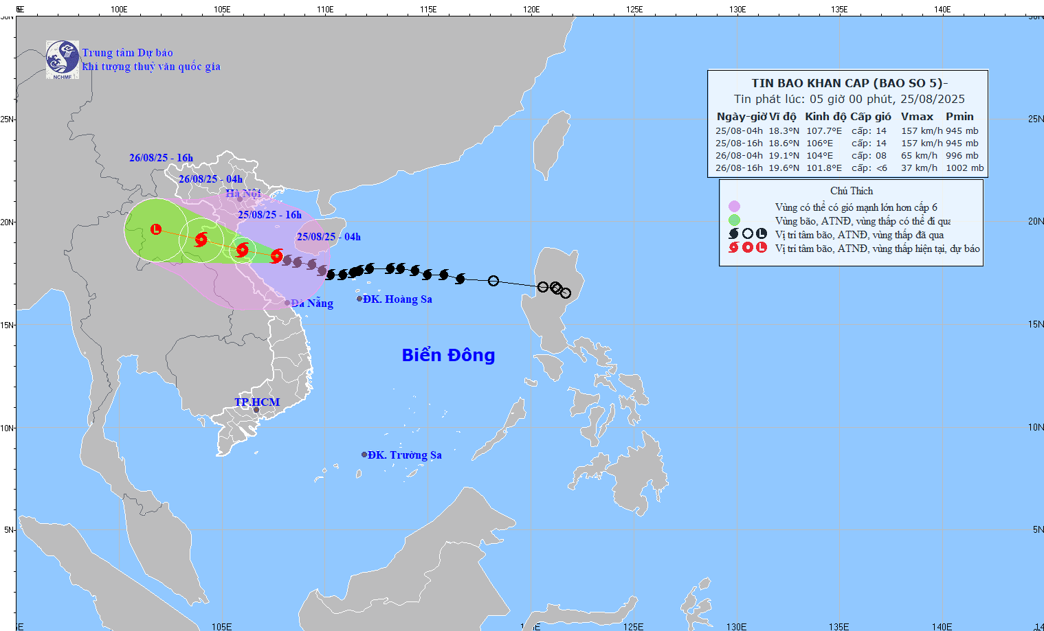
The National Center for Hydro-Meteorological Forecasting said that at 4:00 a.m. today, August 25, the storm's center was at 18.3 degrees North latitude - 107.7 degrees East longitude, only about 220 km from Nghe An, 200 km from Ha Tinh and 180 km north of Quang Tri. The strongest wind near the storm's center remained at level 14, gusting to level 17.

Due to the impact of storm No. 5, on the morning of August 25, many coastal areas in the Central and Northern regions experienced strong winds. Meteorological stations on islands (special zones) such as Bach Long Vi measured winds of level 7 with gusts of level 9, Co To level 6 with gusts of level 9, Bai Chay level 6 with gusts of level 8, Hon Ngu level 7 with gusts of level 8, Con Co level 6 with gusts of level 8.
During the night to the morning of August 25, the storm will continue to move in a West-Northwest direction at a speed of about 20km/hour, likely causing widespread heavy rain and strong winds in the provinces from Nghe An to Quang Tri in the next 24 hours.
The National Center for Hydro-Meteorological Forecasting forecasts that this morning, storm No. 5 will continue to move rapidly in the West-Northwest direction at a speed of about 20km/hour, and will sweep inland from Thanh Hoa to the North of Quang Tri this evening, August 25. The meteorological agency warns that the coastal area from Thanh Hoa to Quang Tri, including Hon Ngu Island and Con Co Special Zone, is at level 4 natural disaster risk - the highest warning level at sea and along the coast.

With wind gusts of up to level 17 when reaching the shore, storm No. 5 is especially dangerous, possibly causing very heavy rain, flash floods, landslides in mountainous areas and widespread flooding in the North Central provinces.
Source: https://www.sggp.org.vn/bao-so-5-dac-biet-nguy-hiem-dia-may-lon-da-cham-vao-mien-trung-post809989.html


Comment (0)