 |
| Forecast of the location and trajectory of Typhoon No. 7 on the morning of November 10th. Photo: National Center for Hydro-Meteorological Forecasting. |
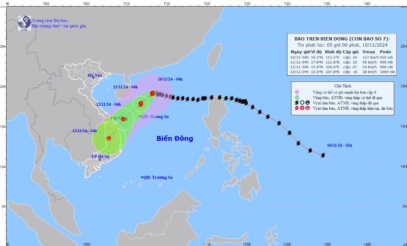
According to the National Center for Hydro-Meteorological Forecasting, at 4:00 AM on November 10th, the typhoon's center was located at approximately 19.1 degrees North latitude and 113.2 degrees East longitude, in the northwestern part of the South China Sea, about 335km north-northeast of the Hoang Sa (Paracel) Islands. The strongest winds near the center of the typhoon reached level 14 (150-166 km/h), with gusts up to level 17; it was moving westward at a speed of about 5 km/h.
Forecasts indicate that by 4:00 AM on November 11th, the storm will move southwest at a speed of 5-10 km/h, with its center located at approximately 17.8 degrees North latitude and 111.8 degrees East longitude, in the northwestern part of the North East Sea, about 145 km north of the Hoang Sa (Paracel) Islands. The strongest winds near the storm's center will be at level 10, with gusts up to level 13. The western part of the North East Sea (including the Hoang Sa Islands) has a level 3 natural disaster risk; specifically, the area between 17-21 degrees North latitude and 111-114.5 degrees East longitude has a level 4 natural disaster risk.
From 4:00 AM on November 12th, the storm moved southwest at a speed of 10-15 km/h, gradually weakening into a tropical depression; the center of the tropical depression was located over the sea area from Quang Tri to Quang Ngai ; the strongest winds near the center of the tropical depression were at level 7, gusting to level 9. The western sea area of the North East Sea (including the Hoang Sa sea area), and the sea area from Quang Tri to Quang Ngai have a level 3 natural disaster risk.
By 4:00 AM on November 13th, the low-pressure system in the Southwest had weakened into a low-pressure area over the Central Highlands, with maximum wind speeds below level 6.
Due to the influence of typhoon No. 7, the northwestern sea area of the North East Sea will experience stormy weather, strong winds of force 8-11, reaching force 12-15 near the center of the typhoon, with gusts up to force 17. The sea areas from Khanh Hoa to Ca Mau , Ca Mau to Kien Giang, and the Gulf of Thailand will have scattered showers and thunderstorms.
On November 10th, both day and night, the northern South China Sea (including the Hoang Sa archipelago) experienced strong winds of force 8-11, reaching force 12-15 near the storm's center, with gusts exceeding force 17; sea waves were 4-6 meters high, and 7-9 meters near the storm's center. The sea area from Khanh Hoa to Ba Ria – Vung Tau experienced northeasterly winds of force 5, sometimes force 6, with gusts up to force 7, during the day, causing rough seas; winds gradually decreased at night; sea waves were 2-4 meters high.
Additionally, on November 10th, both day and night, the northwestern area of the East Sea (including the Hoang Sa archipelago) will experience storms; the sea areas from Binh Thuan to Ca Mau, Ca Mau to Kien Giang, and the Gulf of Thailand will have scattered showers and thunderstorms; during thunderstorms, there is a possibility of tornadoes and strong gusts of wind at levels 7-8.
Experts warn that in the western part of the North East Sea (including the Hoang Sa Islands), winds will be strong, reaching levels 6-8, with winds near the storm's center reaching levels 9-11, gusting to level 14, causing extremely rough seas; wave heights will be 3-5m, and 5-7m near the storm's center. In the east, strong northeasterly winds of levels 6-7, gusting to levels 8-9, will cause rough seas; wave heights will be 3-5m.
The sea area from Quang Tri to Quang Ngai will experience strong winds of level 6, sometimes level 7, with winds near the storm's center reaching level 8, gusting to level 10, and rough seas; wave heights will be 2-4m, and 3-5m near the storm's center. The risk of natural disaster due to strong winds at sea is level 2; the western sea area of the North East Sea (including the Hoang Sa sea area) is level 3, and the northern part is level 4. All vessels operating in these areas are at high risk of being affected by tornadoes, strong winds, and high waves.
Northern Vietnam will be cold at night and early morning, while Southern Vietnam will experience scattered thunderstorms.
Weather forecast for November 10th, day and night: In the Northwest region, there will be fog in some areas in the early morning, followed by sunny weather during the day. It will be cold at night and in the early morning. The lowest temperature will be 17-20°C, with some areas below 17°C. The highest temperature will be 28-31°C.
In the Northeast region and Hanoi, there will be scattered fog and light mist in the early morning, followed by sunny weather during the day. It will be cold at night and in the early morning. The lowest temperature will be 17-20 degrees Celsius, with some mountainous areas experiencing temperatures below 17 degrees Celsius. The highest temperature will be 28-31 degrees Celsius.
In the provinces from Thanh Hoa to Thua Thien - Hue, there will be scattered fog and light mist in the early morning, followed by sunny weather during the day. North to Northwest winds at level 2-3. Cold weather at night and in the early morning. Lowest temperatures from 17-20 degrees Celsius. Highest temperatures from 27-30 degrees Celsius.
Provinces and cities from Da Nang to Binh Thuan will experience sunny weather during the day, with scattered showers and thunderstorms in the evening and at night. Northeast to North winds will be at level 2-3. The lowest temperatures will be 20-23°C in the North and 23-25°C in the South. The highest temperatures will be 29-32°C.


In the Central Highlands, it will be sunny during the day, with scattered showers and thunderstorms in the evening and at night. Northeast winds will be at level 2-3. The lowest temperature will be 16-19 degrees Celsius. The highest temperature will be 27-30 degrees Celsius.
The Southern region will experience scattered showers and thunderstorms in some areas; particularly in the late afternoon and evening, there will be scattered showers and thunderstorms. Northeast winds will be at level 2-3. The lowest temperature will be from 23-26 degrees Celsius. The highest temperature will be from 31-34 degrees Celsius.
Source: https://dangcongsan.vn/xa-hoi/bao-so-7-manh-cap-14-giat-cap-17-682809.html


![[Photo] Strengthening character and expertise: Intense training for artillery soldiers.](https://vphoto.vietnam.vn/thumb/1200x675/vietnam/resource/IMAGE/2026/06/30/1782815602541_lu-368-1875-4571-jpg.webp)