
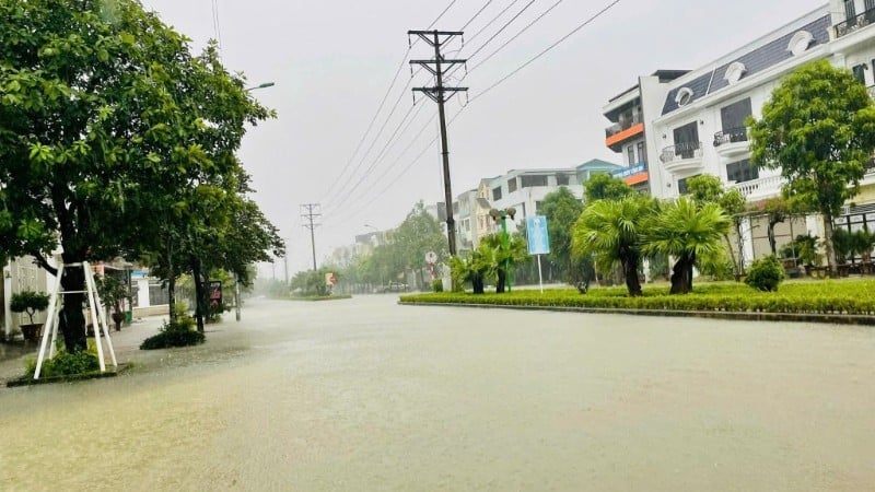
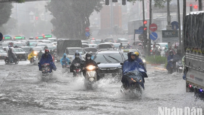
Last night and this morning (September 9), the mountainous areas of the North had moderate rain, heavy rain and scattered thunderstorms, locally very heavy rain with rainfall from 7:00 p.m. on September 8 to 8:00 a.m. on September 9, some places had over 100mm such as Cong Bang station (Thai Nguyen) 132.0mm, Thanh Tin station (Tuyen Quang) 115.8mm, Thach An station ( Cao Bang ) 107.2mm, Lang Mo station (Lai Chau) 104.8mm, Tan Tien station (Lao Cai) 101.6mm,...
It is forecasted that in the next 24-48 hours, from the evening of September 9 to the night of September 10, in the mountainous and midland areas of the North, there will be moderate rain, heavy rain and scattered thunderstorms with common rainfall of 50-100mm, locally very heavy rain over 200mm. Warning of the risk of heavy rain (>100mm/3 hours).
In addition, in the late afternoon and evening of September 9, the Central Highlands and the South will have scattered showers and thunderstorms with rainfall of 10-30mm, with some places having heavy rain of over 60mm.
In the evening and night of September 9, other places in the North will have scattered showers and thunderstorms with rainfall of 15-30mm, locally heavy rain over 70mm; Thanh Hoa and Nghe An will have scattered showers and thunderstorms with rainfall of 10-30mm, locally heavy rain over 70mm. Warning of the risk of heavy rain (>60mm/3 hours).
Thunderstorms may contain tornadoes, lightning, hail and strong winds.
The meteorological agency forecasts that from September 11, heavy rain in the mountainous and midland areas of the North will gradually decrease.
Heavy rain can cause flooding in low-lying areas, urban and industrial areas; flash floods in small rivers and streams; and landslides on steep slopes.
Thunderstorms may contain tornadoes, lightning, hail and strong winds.
Ships operating at sea should be wary of thunderstorms, tornadoes and strong gusts of wind level 6-7.
Currently (September 9), in the Gulf of Tonkin, the sea area from Ca Mau to An Giang , the Gulf of Thailand and the southern East Sea area (including Truong Sa special zone) there are scattered showers and thunderstorms.
It is forecasted that on the night of September 9 and September 10, in the Gulf of Tonkin, the sea area from Lam Dong to Ca Mau, Ca Mau to An Giang, the Gulf of Thailand, and the southern East Sea area (including Truong Sa special zone), there will be scattered showers and thunderstorms.
During thunderstorms, there is a possibility of tornadoes, strong gusts of wind of level 6-7 and waves over 2m high. All vessels operating in the above areas are at risk of being affected by tornadoes and strong gusts of wind.
Source: https://nhandan.vn/canh-bao-nguy-co-mua-cuong-suat-lon-tai-vung-nui-va-trung-du-bac-bo-post906949.html
![[Photo] Prime Minister Pham Minh Chinh launched a peak emulation campaign to achieve achievements in celebration of the 14th National Party Congress](https://vphoto.vietnam.vn/thumb/1200x675/vietnam/resource/IMAGE/2025/10/5/8869ec5cdbc740f58fbf2ae73f065076)


![[Photo] Prime Minister Pham Minh Chinh chairs the Government's online conference with localities](https://vphoto.vietnam.vn/thumb/1200x675/vietnam/resource/IMAGE/2025/10/5/264793cfb4404c63a701d235ff43e1bd)


![[Photo] Prime Minister Pham Minh Chinh chairs the Government's online conference with localities](https://vphoto.vietnam.vn/thumb/402x226/vietnam/resource/IMAGE/2025/10/5/264793cfb4404c63a701d235ff43e1bd)


![[VIDEO] Summary of Petrovietnam's 50th Anniversary Ceremony](https://vphoto.vietnam.vn/thumb/402x226/vietnam/resource/IMAGE/2025/10/4/abe133bdb8114793a16d4fe3e5bd0f12)

![[VIDEO] GENERAL SECRETARY TO LAM AWARDS PETROVIETNAM 8 GOLDEN WORDS: "PIONEER - EXCELLENT - SUSTAINABLE - GLOBAL"](https://vphoto.vietnam.vn/thumb/402x226/vietnam/resource/IMAGE/2025/7/23/c2fdb48863e846cfa9fb8e6ea9cf44e7)


Comment (0)