
 |
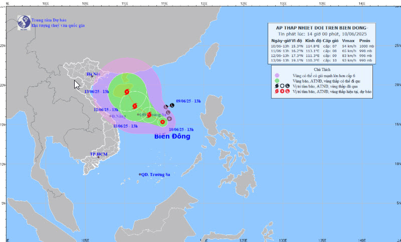
| Map of forecast trajectory and intensity of tropical depression at 2:00 p.m. on June 10. |
On the afternoon of June 10, Mr. Mai Van Khiem, Director of the National Center for Hydro-Meteorological Forecasting, said that at 1 p.m., the center of the tropical depression was at about 15.3 degrees North latitude; 114.8 degrees East longitude, about 360 km East Southeast of Hoang Sa sea; moving slowly in the West Northwest direction at a speed of about 5 km/hour. The strongest wind near the center of the tropical depression was level 6 - 7 (39 - 61 km/hour), gusting to level 9.
The meteorological agency forecasts that at around 1pm on June 11, the center of the tropical depression will be at around 16.2 degrees North latitude; 113.1 degrees East longitude, in the eastern area of the Hoang Sa sea; moving in the West Northwest direction at a speed of around 5-10 km/hour and is likely to strengthen into a storm. The strongest wind near the center of the tropical depression will be at level 8, gusting to level 10. The affected areas will be the northern East Sea (including the Hoang Sa sea) and the northern area of the central East Sea.
Forecast at 1:00 p.m. on June 12, the center of the storm is at about 17.3 degrees North latitude; 111.3 degrees East longitude, in the northwest area of the Hoang Sa archipelago; moving in the West Northwest direction at a speed of about 10 km/hour and is likely to strengthen. The strongest wind near the center of the tropical depression is level 9, gusting to level 11. The affected area is the North East Sea (including the Hoang Sa sea area), the North of the Central East Sea area and the offshore waters from Quang Tri to Quang Ngai.
Sharing with the press, Mr. Nguyen Van Huong, Head of Weather Forecast Department, National Center for Hydro-Meteorological Forecasting, said that there are two scenarios for the path of the tropical depression. The most likely scenario is that the tropical depression will move to the Hoang Sa archipelago and strengthen into a storm, then change direction to move north, entering the eastern area of Hainan Island (China). However, it is also possible that when the storm moves to Hainan Island, it will change direction and move into the Gulf of Tonkin, but the probability of this case is not high.
Due to the influence of the tropical depression, at sea, the North East Sea area (including the waters of Hoang Sa archipelago), the North of the Central East Sea area has thunderstorms and strong winds of level 6 - 7, then increasing to level 8, gusting to level 11, waves 2 - 4 m high, rough seas; the South of the Central East Sea area, the South East Sea area (including the waters of Truong Sa archipelago) has strong southwest winds of level 6, sometimes level 7, gusting to level 8 - 9, waves 2 - 4 m high, rough seas. Ships operating in the above-mentioned dangerous areas are likely to be affected by thunderstorms, whirlwinds, strong winds, and big waves.
News and People Newspaper
Source: https://baodanang.vn/xa-hoi/202506/cap-nhat-duong-di-cua-ap-thap-nhiet-doi-kha-nang-cao-manh-len-thanh-bao-so-1-4008487/

![[Photo] Third session of the Committee for Drafting Amendments and Supplements to a Number of Articles of the 2013 Constitution](https://vphoto.vietnam.vn/thumb/1200x675/vietnam/resource/IMAGE/2025/6/11/16cab51dafc741719485978eb3ed8ce3)

![[Photo] General Secretary To Lam works with Lam Dong, Binh Thuan and Dak Nong provinces](https://vphoto.vietnam.vn/thumb/1200x675/vietnam/resource/IMAGE/2025/6/11/c3e736d90cda4fe78f96c9bfb68d4e0b)


Comment (0)