
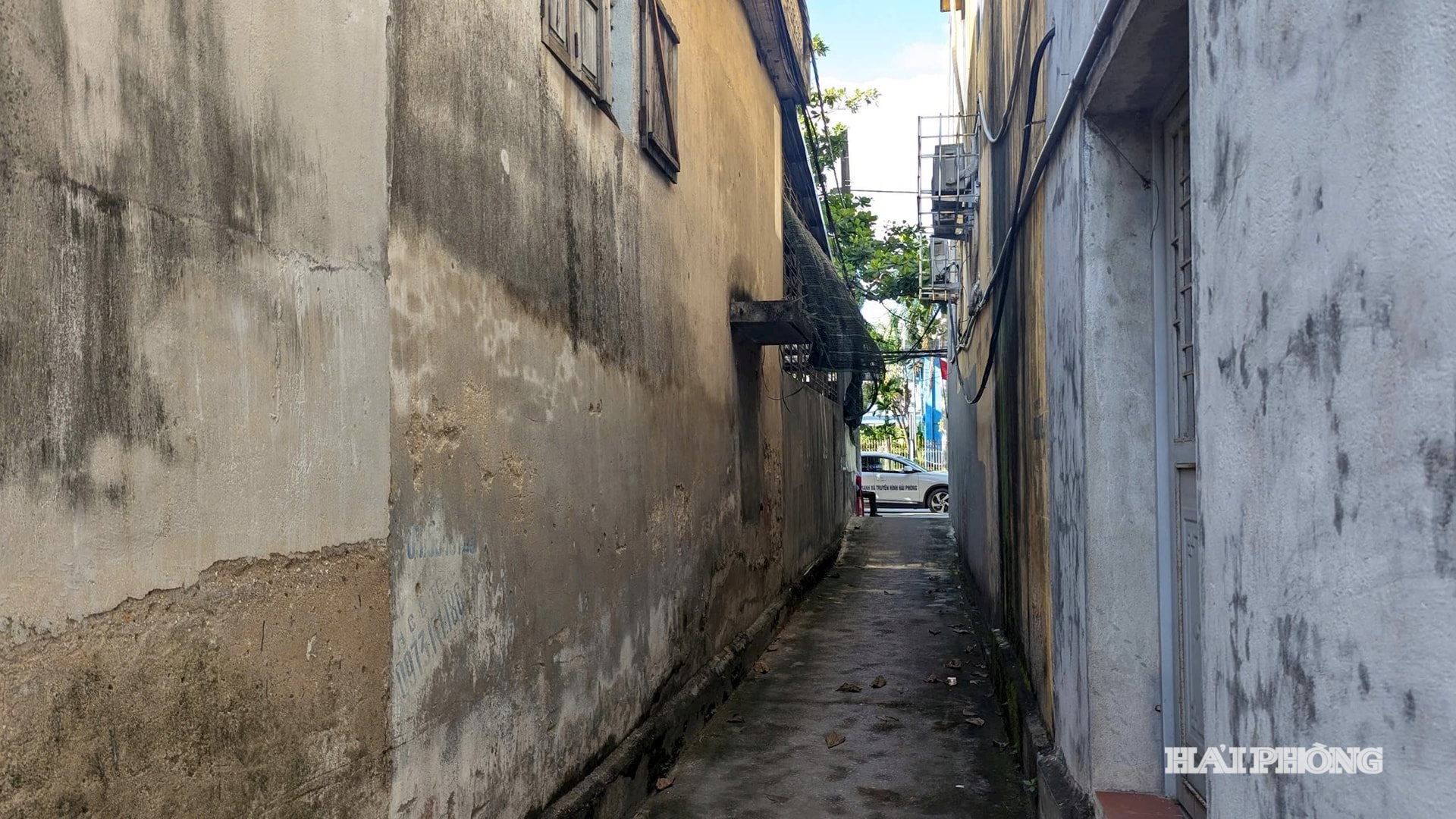
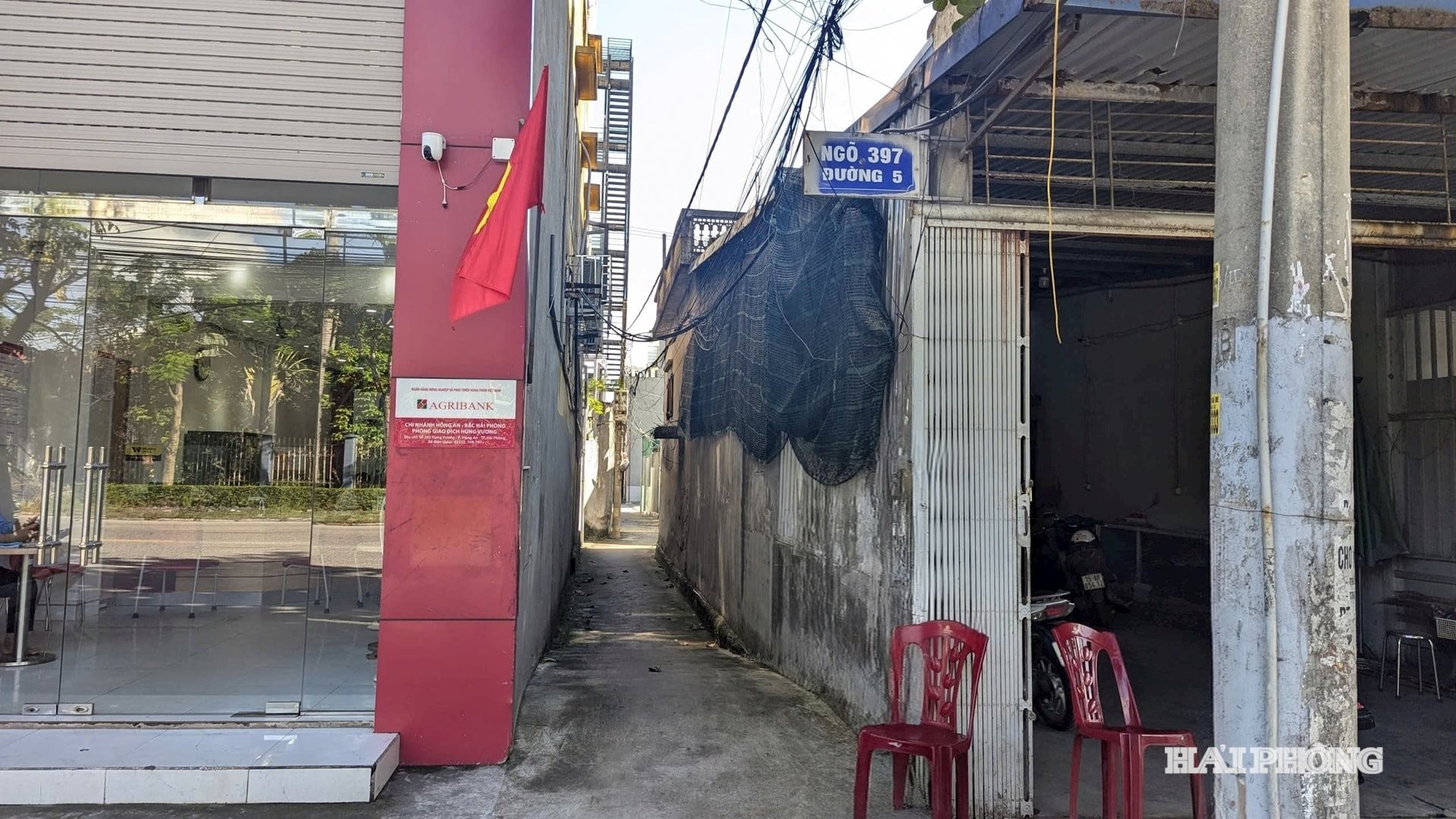
According to the petition, Alley 397 used to have an average width of about 2.5 m. After Mr. Doan Kim Thang's household (house number 397, Hung Vuong ward) built a house and a surrounding wall, the residents said that the common path was narrowed. In 2010, the residents expressed their opinions and sent a petition to the People's Committee of Quan Toan ward. At that time, Mr. Thang said (verbally) that he would return the land of the common path when renovating his house. However, 15 years have passed and this commitment has not been fulfilled. Recently, some households continued to send petitions to the People's Committee of Hong An ward to consider and resolve the issue.
On September 5, 2025, the People's Committee of Hong An Ward issued a written response to the petition. Accordingly, the current status of the land that Mr. Doan Kim Thang's household is managing and using is plot No. 32, map sheet No. 35, area 245.5 m2 , residential land type. According to the cadastral map of Quan Toan Ward established in 1997, the shared alley 397 next to Mr. Thang's house has a width of 1.5 - 1.8 m, and up to now, it has remained the same, without changing its size or shape. Therefore, the petition of the households in the alley is unfounded.
However, the households in lane 397 said that the resolution of the petition by the People's Committee of Hong An ward was not satisfactory. Mr. Nguyen Huy Du, a household in lane 397, said that this area was previously cultivated land, then the People's Committee of Nam Son commune, An Duong district (old) granted to households with an area of 200 m2 /household (8 m wide, 25 m long), including Mr. Doan Kim Thang's family. This area is clearly shown in the "minutes of land crop compensation fee collection" established in 1989 by the People's Committee of Nam Son commune. Thus, the measurement of the land area used by Mr. Doan Kim Thang's family of 245.5 m2 according to the cadastral map of Quan Toan ward established in 1997 does not match the data from the People's Committee of Nam Son commune.
The households said that based on the land area that Mr. Thang's household is currently using, the difference (2m wide) compared to the land area allocated according to the "Minutes of land crop compensation fee collection" established in 1989 by the People's Committee of Nam Son commune is due to Mr. Doan Kim Thang's household encroaching on the shared alley. However, the documents provided by the households in alley 397 do not show information about the width of alley 397.
Discussing the current land use, Ms. Chu Thi Cuc, Mr. Thang's wife, informed that since 1984, her family has been granted the land plot they are currently living on by Nam Son Cooperative. Previously, the documents granted the family 200 m2 , but later when Nam Son Cooperative came to re-measure, the family requested to use the excess area. Therefore, the land area her family is using is 10 m wide and 25 m long. Since 1985, when the house was built until now, the current land status of her family has not changed.
Working with reporters, Ms. Pham Thi Thuy Nhung, Deputy Head of the Economic , Infrastructure and Urban Affairs Department of Hong An Ward, said that after receiving the petition from a number of households in lane 397, the ward carried out the settlement procedures according to regulations. Based on the cadastral map of Quan Toan Ward established in 1997, it is clear that the alley is 1.5 - 1.8m wide, so the petition of the households in the alley to Mr. Thang's household is unfounded.
Through the documents provided by the People's Committee of Hong An Ward, it can be seen that in the land handover records of Nam Son Commune in 1994, plot 347 with an area of 200 m2 in the name of Doan Van Thang (the plot of land that the households believe belongs to Mr. Doan Kim Thang's household) is not adjacent to the common alley. However, the adjacent plot 348 with an area of 248 m2 in the name of Nguyen Van Thang is shown to be adjacent to the common alley. In the cadastral map of Quan Toan Ward in 1997, map sheet number 35 clearly shows the land area in use of Mr. Doan Kim Thang's household is 245.5 m2 .
Also according to the working minutes dated July 18, 2025 of the People's Committee of Hong An Ward, after receiving the petition of households in lane 397, civil servants of the Ward Economic, Infrastructure and Urban Affairs Department and residential group officials worked with a number of households in lane 397 and Mr. Doan Kim Thang's household to record the current land use status in lane 397.
Lawyer Nguyen Van Thuan, Director of Bach Dang Giang Law Firm, City Bar Association, said that the People's Committee of Hong An Ward used the cadastral map of Quan Toan Ward established in 1997 as the basis for resolving the case, which is reasonable because this is a cadastral map approved by a competent State agency. In case the households do not agree with the response to the petition of the People's Committee of Hong An Ward, the households can petition a higher authority for consideration and resolution.
Thus, the petition of the households in lane 397 Hung Vuong street has been considered and resolved by the local government. The documents show that there is not enough evidence to prove that Mr. Doan Kim Thang's household encroached on lane 397 Hung Vuong street.
However, because the households do not agree with the response of the People's Committee of Hong An Ward, they continue to make prolonged petitions. To resolve the above issue, the People's Committee of Hong An Ward needs to increase propaganda so that households understand and agree. In case households do not agree, they need to provide additional grounds and documents to prove their point of view or file a lawsuit at a competent court to clarify the case. Do not make prolonged petitions or go beyond the level that affect local security and order.
HA MINHSource: https://baohaiphong.vn/co-hay-khong-viec-lan-chiem-dat-chung-ngo-397-duong-hung-vuong-523535.html
![[Photo] Worshiping the Tuyet Son statue - a nearly 400-year-old treasure at Keo Pagoda](/_next/image?url=https%3A%2F%2Fvphoto.vietnam.vn%2Fthumb%2F1200x675%2Fvietnam%2Fresource%2FIMAGE%2F2025%2F12%2F02%2F1764679323086_ndo_br_tempimageomw0hi-4884-jpg.webp&w=3840&q=75)

![[Photo] Parade to celebrate the 50th anniversary of Laos' National Day](/_next/image?url=https%3A%2F%2Fvphoto.vietnam.vn%2Fthumb%2F1200x675%2Fvietnam%2Fresource%2FIMAGE%2F2025%2F12%2F02%2F1764691918289_ndo_br_0-jpg.webp&w=3840&q=75)


Comment (0)