
Project overview and projected timeline
The Ho Chi Minh City People's Committee has recently sent a document to relevant ministries and agencies to solicit feedback on the proposal for the investment in a bridge and road project connecting Can Gio District (Ho Chi Minh City) and Vung Tau City. According to the proposal, the project could commence in June 2026 and is expected to be completed and put into operation from the second quarter of 2029.
This project was proposed by Vingroup Corporation under a public-private partnership (PPP) model, specifically a build-transfer (BT) contract. Due to its large scale and impact on multiple sectors such as maritime affairs, urban planning, and water resources, the Ho Chi Minh City People's Committee is currently consulting with central government agencies to establish a basis for appraisal and approval of the investment plan.

Planning details and route
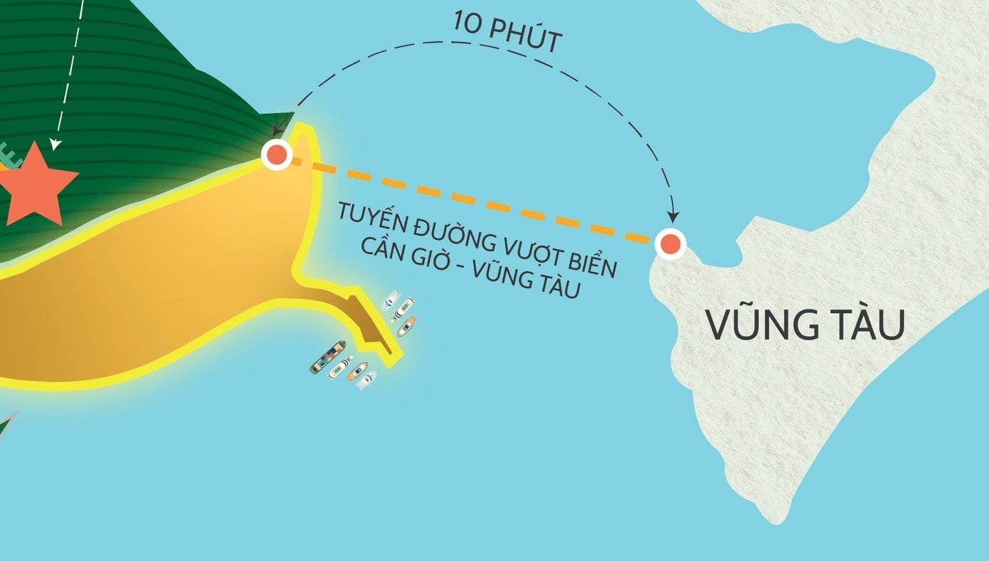
According to the proposed plan, the Can Gio sea bridge and road will start at Bien Dong 2 road, within the Can Gio reclaimed land urban area. The end point of the route will connect to the planned Mai Sao - Ben Dinh road and intersect with 30/4 road in Vung Tau City. The main route is southeast, crossing Ghenh Rai Bay.
The total length of the entire route is over 14 km, including approximately 3.1 km of tunnels, nearly 8 km of bridges, and about 3 km of access roads. The project is expected to utilize approximately 137.5 hectares of land. Detailed parameters regarding water surface area and material volume will be determined during the specific project planning phase.
Technical specifications of the project
In terms of technical scale, the project is designed according to Class I road standards for the road section and special class bridge standards for the sea bridge section. The expected design speed is 80 km/h on the road section and 60 km/h on the bridge section.
The sea bridge project features a 22.5-meter wide cross-section, accommodating four lanes for motorized vehicles and two lanes for mixed traffic, along with a median strip and safety railings. The bridge is planned as a cable-stayed structure with a main span of approximately 600 meters, suitable for the complex geological and hydrological conditions of Ghenh Rai Bay. Notably, the bridge will have a clearance of approximately 55 meters, ensuring access for large cargo ships to and from the Cai Mep - Thi Vai port complex.
Economic impact and connectivity potential
Currently, travel between Can Gio and Vung Tau is mainly via National Highway 51 or ferry, taking 90 to 120 minutes. The completed sea-crossing bridge is expected to shorten travel time to approximately 10 minutes, creating a direct coastal connection between Ho Chi Minh City and Ba Ria - Vung Tau .
The project is expected to create a strong impetus for the development of the Can Gio coastal tourism area and the Long Son industrial park. At the same time, the project will help improve the operational capacity of the Cai Mep - Thi Vai deep-water port complex and reduce traffic pressure on National Highway 51, contributing to the socio-economic development of the entire region.
Source: https://baolamdong.vn/du-an-cau-vuot-bien-can-gio-vung-tau-lo-trinh-and-quy-mo-410877.html

![[Image] Leaked images ahead of the 2025 Community Action Awards gala.](/_next/image?url=https%3A%2F%2Fvphoto.vietnam.vn%2Fthumb%2F1200x675%2Fvietnam%2Fresource%2FIMAGE%2F2025%2F12%2F16%2F1765882828720_ndo_br_thiet-ke-chua-co-ten-45-png.webp&w=3840&q=75)
![[Live] 2025 Community Action Awards Gala](/_next/image?url=https%3A%2F%2Fvphoto.vietnam.vn%2Fthumb%2F1200x675%2Fvietnam%2Fresource%2FIMAGE%2F2025%2F12%2F16%2F1765899631650_ndo_tr_z7334013144784-9f9fe10a6d63584c85aff40f2957c250-jpg.webp&w=3840&q=75)
![[Photo] Prime Minister Pham Minh Chinh receives the Governor of Tochigi Province (Japan)](/_next/image?url=https%3A%2F%2Fvphoto.vietnam.vn%2Fthumb%2F1200x675%2Fvietnam%2Fresource%2FIMAGE%2F2025%2F12%2F16%2F1765892133176_dsc-8082-6425-jpg.webp&w=3840&q=75)
![[Photo] Prime Minister Pham Minh Chinh receives Lao Minister of Education and Sports Thongsalith Mangnormek](/_next/image?url=https%3A%2F%2Fvphoto.vietnam.vn%2Fthumb%2F1200x675%2Fvietnam%2Fresource%2FIMAGE%2F2025%2F12%2F16%2F1765876834721_dsc-7519-jpg.webp&w=3840&q=75)


![[Photo] Prime Minister Pham Minh Chinh attends the Vietnam Economic Forum 2025](https://vphoto.vietnam.vn/thumb/402x226/vietnam/resource/IMAGE/2025/12/16/1765893035503_ndo_br_dsc-8043-jpg.webp)


Comment (0)