
Specifically, according to Director of the National Center for Hydro-Meteorological Forecasting Mai Van Khiem, from the night of October 22 to October 24, communes and wards at risk of heavy rain in Quang Tri province include: Minh Hoa, Dong Le, Phu Trach, Ba Don, Phong Nha, Hoan Lao, Dong Hoi, Truong Son, Le Thuy, Kim Ngan from 100-250 mm, some places over 300 mm; Vinh Linh, Con Tien and Con Co 150-300 mm, some places over 400 mm; Gio Linh, Cua Viet, Dong Ha Cam Lo, Quang Tri, Hai Lang, Khe Sanh and Dakrong 250-400 mm, some places over 550 mm. Warning of heavy rain over 200mm/3 hours.
Communes and wards in Hue city with heavy rainfall include: Phong Dinh, Phong Phu, Phong Quang, Dan Dien, Quang Dien, Thuan An, Hoa Chau, Duong No, Kim Tra, Huong An, Kim Long, Thuan Hoa, Phu Xuan, An Cuu, Thuy Xuan, Vy Da, My Thuong, Phu Ho, Thanh Thuy, Phu Vinh, Phu Vang, Huong Thuy, Vinh Loc from 250-450mm, some places over 600mm; A Luoi from 1-4 is 350-500mm, some places over 650mm. Warning of heavy rain over 200mm/3 hours.
Communes and wards of Phong Dien, Phong Thai, Huong Tra, Binh Dien, A Luoi 5, Phu Bai, Hung Loc, Phu Loc, Loc An, Khe Tre, Chan May - Lang Co, Long Quang, Nam Dong have rainfall from 350-500mm, some places over 700mm. Warning of heavy rain over 200mm/3 hours.
For Da Nang city, communes and wards with heavy rain include: Hai Van, Hoa Khanh, Hai Chau, Cam Le, Son Tra, Ngu Hanh Son, Hoi An, Hoa Tien, Dien Ban, Dai Loc from 250-450mm, some places over 700mm. Warning of heavy rain over 200mm/3 hours,
Communes and wards such as Thang Binh, Tam Ky, Nui Thanh from 200-400mm, some places over 600mm; Dong Giang, Tay Giang, Thanh My from 200-350mm, some places over 400mm; Que Son, Tien Phuoc, Kham Duc, Tra My: 250-500mm, some places over 700mm. Warning of heavy rain over 200mm/3 hours.
Hoang Sa special zone has rain from 100-200 mm, in some places over 300 mm.
Along with that, communes and wards in Quang Ngai province have heavy rain including: Special Zone Ly Son, Cam Thanh, Binh Son, Tra Bong from 100 - 200mm, some places over 250mm; Ba To, Son Tay, Duc Pho from 80 - 140mm, some places over 200mm; Ngoc Linh, Dak Pek, Mang Den from 60 - 80mm, some places over 120mm.
Heavy rains in the Central region are likely to last until the end of October 2025. There is a high risk of flash floods and landslides in mountainous areas, and flooding in low-lying and urban areas.
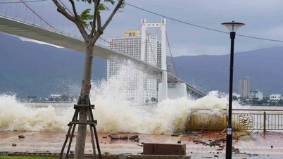
Due to the influence of storm circulation No. 12 combined with strong cold air, from the evening of October 22, on the mainland coastal provinces from Quang Tri to Da Nang City, the wind gradually increased to level 6, sometimes level 7, gusting to level 8-9.
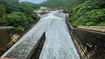
"Localities need to pay attention to safely operating hydroelectric and irrigation reservoirs before, during and after the storm, and prepare response plans for flood scenarios on rivers from Quang Tri to Quang Ngai that may reach alert level 3 and exceed alert level 3. Forecast level of natural disaster risk due to floods and inundation: level 3. Be on guard against the risk of thunderstorms, tornadoes with strong gusts of wind in the storm's circulation area, both before and during the storm's landfall," Associate Professor, Doctor, Director of the National Center for Hydro-Meteorological Forecasting Mai Van Khiem noted.
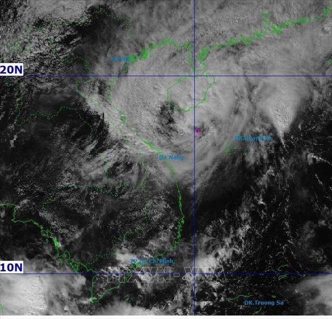
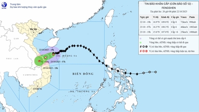
According to the National Center for Hydro-Meteorological Forecasting, at 1:00 p.m. on October 22, the eye of the storm was located at about 17.1 degrees North latitude; 110.2 degrees East longitude, in the sea northwest of Hoang Sa special zone, about 230 km East Northeast of Da Nang City. The strongest wind near the eye of the storm was level 10 (89-102 km/h), gusting to level 12. Moving westward at a speed of 5-10 km/h.
Forecast by 1:00 a.m. on October 23, the storm is about 100 km east-northeast of Da Nang city, with strong winds of level 8, gusts of level 10, moving west-southwest at a speed of about 10 km/h and gradually weakening. The affected area is the western sea area of the North East Sea (including Hoang Sa special zone), the sea area from Quang Tri to Quang Ngai (including the special zones of Con Co island, Ly Son and Cu Lao Cham island), the mainland along the coast of provinces and cities from Quang Tri to Da Nang. Disaster risk level 3.
Then, at 1:00 p.m. on October 23, the storm in the area from Hue city to Da Nang, with winds below level 6, moved in the West Southwest direction at a speed of about 15 km/h and gradually weakened into a low pressure area. The affected area is the sea from Quang Tri to Quang Ngai (including the special zones of Con Co island, Ly Son and Cu Lao Cham island); the mainland coastal provinces and cities from Quang Tri to Da Nang.
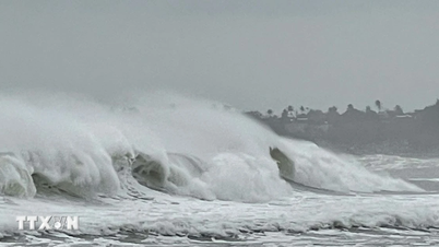
Due to the impact of the storm, the western sea area of the North East Sea (including Hoang Sa special zone) has strong winds of level 7-8; the area near the storm's eye has strong winds of level 9-10, gusting to level 12; waves 3-5m high, the area near the storm's eye has waves of 5-7m high, very rough seas.
The sea area from Quang Tri to Quang Ngai (including Con Co special zone, Cu Lao Cham island and Ly Son special zone) has strong winds of level 6-7, the area near the storm's eye has winds of level 8-9, gusts of level 11, waves 3-5m high, rough seas.
Coastal areas from Quang Tri to Da Nang City have storm surges ranging from 0.4 to 0.8 meters high.
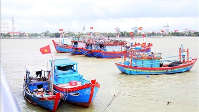
Warning: Coastal areas and river mouths from Quang Tri to Da Nang city need to be on guard against large waves combined with high tides and storm surges causing flooding in low-lying areas, waves overflowing coastal roads and riverbanks, and coastal erosion. All ships, boats, and aquaculture areas in the above-mentioned dangerous areas are at risk of being affected by storms, whirlwinds, strong winds, large waves, and high tides.
Source: https://baotintuc.vn/xa-hoi/du-bao-ven-bien-tu-quang-tri-den-da-nang-mua-lon-do-anh-huong-bao-so-12-20251022151436828.htm

![[Photo] Award Ceremony of the Political Contest on Protecting the Party's Ideological Foundation](https://vphoto.vietnam.vn/thumb/1200x675/vietnam/resource/IMAGE/2025/10/22/1761151665557_giaia-jpg.webp)
![[Photo] Da Nang: Shock forces protect people's lives and property from natural disasters](https://vphoto.vietnam.vn/thumb/1200x675/vietnam/resource/IMAGE/2025/10/22/1761145662726_ndo_tr_z7144555003331-7912dd3d47479764c3df11043a705f22-3095-jpg.webp)
![[Photo] Prime Minister Pham Minh Chinh chairs meeting on nuclear power plant construction](https://vphoto.vietnam.vn/thumb/1200x675/vietnam/resource/IMAGE/2025/10/22/1761137852450_dsc-9299-jpg.webp)


Comment (0)