

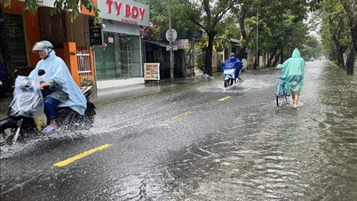
Very heavy rain in many areas
The National Center for Hydro-Meteorological Forecasting said that from 7:00 p.m. on October 22 to 7:00 p.m. on October 24, from Ha Tinh to Quang Ngai, there will be heavy rain and thunderstorms with common rainfall of 100-250mm, and locally very heavy rain of over 350mm.
Warning of risk of heavy rain over 200mm/3h.
In addition, in the evening and night of October 22, the area from Dak Lak to Lam Dong and the South will have scattered showers and thunderstorms with rainfall ranging from 15-30mm, with some places experiencing heavy rain of over 80mm. During thunderstorms, there is a possibility of tornadoes, lightning, hail and strong gusts of wind.
Warning of risk of heavy rain over 60mm/3h.
In the next 48 to 72 hours, in the area from Ha Tinh to Quang Ngai, there will be moderate rain, heavy rain and thunderstorms, locally very heavy rain with common rainfall from 40-80mm, locally over 150mm. Heavy rain in this area is likely to last until the end of October 2025.
Natural disaster risk level due to heavy rain, tornado, lightning, hail: level 1; area from South Quang Tri to Da Nang City level 2.
Heavy rains are likely to cause flooding in low-lying areas, urban and industrial areas; flash floods on small rivers and streams, landslides on steep slopes (real-time warning information on areas at risk of flash floods and landslides is provided online on the website of the Department of Hydrometeorology at: https://luquetsatlo.nchmf.gov.vn and in a separate bulletin warning of flash floods and landslides). During thunderstorms, there is a possibility of tornadoes, lightning, hail and strong gusts of wind.
In the Northern mountainous region, some places are below 16 degrees Celsius.
The National Center for Hydro-Meteorological Forecasting forecasts that currently (October 22), cold air has affected some places in the Central Central region. At Bach Long Vi station, there are strong northeast winds of level 7, gusts of level 9; Con Co station has strong northeast winds of level 6, gusts of level 7; Ly Son station has strong winds of level 6, gusts of level 8.
It is forecasted that in the evening and night of October 22, cold air will continue to affect other places in the Central Central region. Inland, strong northeast winds will be level 3, coastal areas level 4, and in some places level 5; coastal provinces from Quang Tri to Da Nang city, due to the influence of storm No. 12's circulation combined with strong cold air, from the evening of October 22, winds will gradually increase to level 6, sometimes level 7, gusting to level 8-9.
In the Northern region and Thanh Hoa, the weather is cold at night and in the morning, and in the mountainous areas. The lowest temperature during this cold air mass in the Northern Delta and Thanh Hoa is generally 19-22 degrees Celsius, in the mountainous and midland areas of the North it is 17-19 degrees Celsius, and in the high mountains it is below 16 degrees Celsius in some places.
Hanoi area: no rain. Cold at night and morning. The lowest temperature during this cold air mass is commonly 19-22 degrees Celsius.
At sea, due to the influence of cold air combined with the circulation of storm No. 12, the North East Sea area (including Hoang Sa special zone) has strong northeast winds of level 7-8; in particular, the western sea area near the storm's eye has strong winds of level 9-10, gusts of level 12, waves 3-5m high, areas near the storm's eye have waves of 5+7m high, very rough seas.
The Gulf of Tonkin has strong northeast winds of level 7, gusts of level 9, rough seas, waves 2-4m high. The sea area from Quang Tri to Quang Ngai (including Con Co special zone, Ly Son special zone and Cu Lao Cham island) has strong winds of level 6-7, the area near the storm's eye has winds of level 8, gusts of level 10, waves 3-5m high, rough seas.
Due to the influence of cold air and circulation of storm No. 12 combined with disturbances in the upper easterly wind zone, there has been widespread heavy rain in the area from Ha Tinh to Quang Ngai since the night of October 22.
Thunderstorms accompanied by tornadoes, lightning, hail and strong gusts of wind can affect agricultural production, break trees, damage houses, traffic works and infrastructure.
Heavy rain can cause flooding in low-lying areas; flash floods in small rivers and streams, landslides on steep slopes; heavy rain in a short period of time can cause flooding in urban areas and industrial zones.
Strong winds and gusts, large waves at sea are likely to affect boating and other activities.
Cold weather at night and morning can affect health.
Weather in different regions on the night of October 22 and October 23
In the Northwest, there will be rain at night in some places; sunny during the day, cold at night and morning, some places will be chilly. Light wind. Lowest temperature 18-21 degrees Celsius, some places below 17 degrees Celsius. Highest temperature 25-28 degrees Celsius.
There will be rain in some places in the Northeast. Northeast wind level 3, especially in coastal areas level 4, some places level 5. Cold at night and morning, cold in mountainous areas. Lowest temperature 19-21 degrees Celsius, mountainous and midland areas 17-19 degrees Celsius, high mountainous areas have places below 16 degrees Celsius. Highest temperature 24-27 degrees Celsius, some places above 27 degrees Celsius.
Hanoi city has no rain, cold at night and morning. Northeast wind level 3. Lowest temperature 19-21 degrees Celsius. Highest temperature 24-26 degrees Celsius.
Provinces and cities from Thanh Hoa - Hue, the North (Thanh Hoa - Nghe An) have rain in some places. The South (from Ha Tinh - Hue City) has moderate rain, heavy rain and thunderstorms, locally very heavy rain; especially in South Quang Tri and Hue City there is heavy to very heavy rain. North to Northwest wind level 3, coastal areas level 4, some places level 5; coastal areas from Quang Tri to Hue City wind gradually increases to level 6, sometimes level 7, gusting to level 8-9. During thunderstorms there is a possibility of tornadoes, lightning and strong gusts. Lowest temperature 20-23 degrees Celsius. Highest temperature 24-27 degrees Celsius.
South Central Coast, North has moderate rain, heavy rain and thunderstorms, locally very heavy rain in some places; Da Nang city in particular has heavy to very heavy rain; North to Northwest wind level 3, from the afternoon on the coast of Da Nang city the wind gradually increases to level 6, sometimes level 7, gusting to level 8-9. South has scattered showers and thunderstorms in some places; tonight and tomorrow evening there are scattered showers and thunderstorms, locally heavy rain in some places; North to Northeast wind level 2-3; in thunderstorms there is a possibility of tornadoes, lightning and strong gusts. Lowest temperature 23-26 degrees Celsius. Highest temperature in the North 26-29 degrees Celsius, in the South 29-32 degrees Celsius.
The Central Highlands has scattered showers and thunderstorms, with scattered showers and thunderstorms in the afternoon and evening, with some heavy rain in some places. Light wind. During thunderstorms, there is a possibility of tornadoes, lightning, hail and strong gusts of wind. Lowest temperature 19-22 degrees Celsius. Highest temperature 27-30 degrees Celsius, some places above 30 degrees Celsius.
The South has scattered showers and thunderstorms, with scattered showers and thunderstorms in the afternoon and evening, and locally heavy rain. Thunderstorms may cause tornadoes, lightning, hail, and strong gusts of wind. Lowest temperature 23-26 degrees Celsius. Highest temperature 31-34 degrees Celsius.
Ho Chi Minh City has scattered showers and thunderstorms, with scattered showers and thunderstorms in the afternoon and evening, and locally heavy rain. Thunderstorms may cause tornadoes, lightning, hail, and strong gusts of wind. Lowest temperature 24-26 degrees Celsius. Highest temperature 32-34 degrees Celsius.
Source: https://baotintuc.vn/xa-hoi/anh-huong-bao-so-12-mua-to-cuc-bo-tu-nam-quang-tri-den-thanh-pho-da-nang-20251022175534638.htm


![[Photo] Urgently help people soon have a place to live and stabilize their lives](/_next/image?url=https%3A%2F%2Fvphoto.vietnam.vn%2Fthumb%2F1200x675%2Fvietnam%2Fresource%2FIMAGE%2F2025%2F12%2F09%2F1765248230297_c-jpg.webp&w=3840&q=75)


![[Photo] General Secretary To Lam works with the Standing Committees of the 14th Party Congress Subcommittees](https://vphoto.vietnam.vn/thumb/402x226/vietnam/resource/IMAGE/2025/12/09/1765265023554_image.jpeg)


Comment (0)