
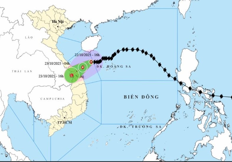
At 5:00 p.m. on October 22, the center of storm No. 12 was at about 17.1 degrees north latitude, 109.8 degrees east longitude, about 200km east-northeast of Da Nang city, with the strongest wind at level 9, gusting to level 11.
The storm is moving west-southwest at about 10km/h and continues to weaken.
According to the storm forecast bulletin No. 12 of the Central Hydrometeorological Station, at 4:00 a.m. on October 23, the center of the storm was at about 16.5 degrees north latitude, 108.8 degrees east longitude, about 100km east-northeast of Da Nang city with the strongest wind at level 8, gusting to level 10.
The storm continued to weaken into a tropical depression, moving west-southwestwards towards the mainland and continued to weaken into a low pressure area.
At 4:00 p.m. on October 23, the center of the storm was at about 15.6 degrees north latitude, 107.5 degrees east longitude, in the area west of Da Nang city with the strongest wind still below level 6.
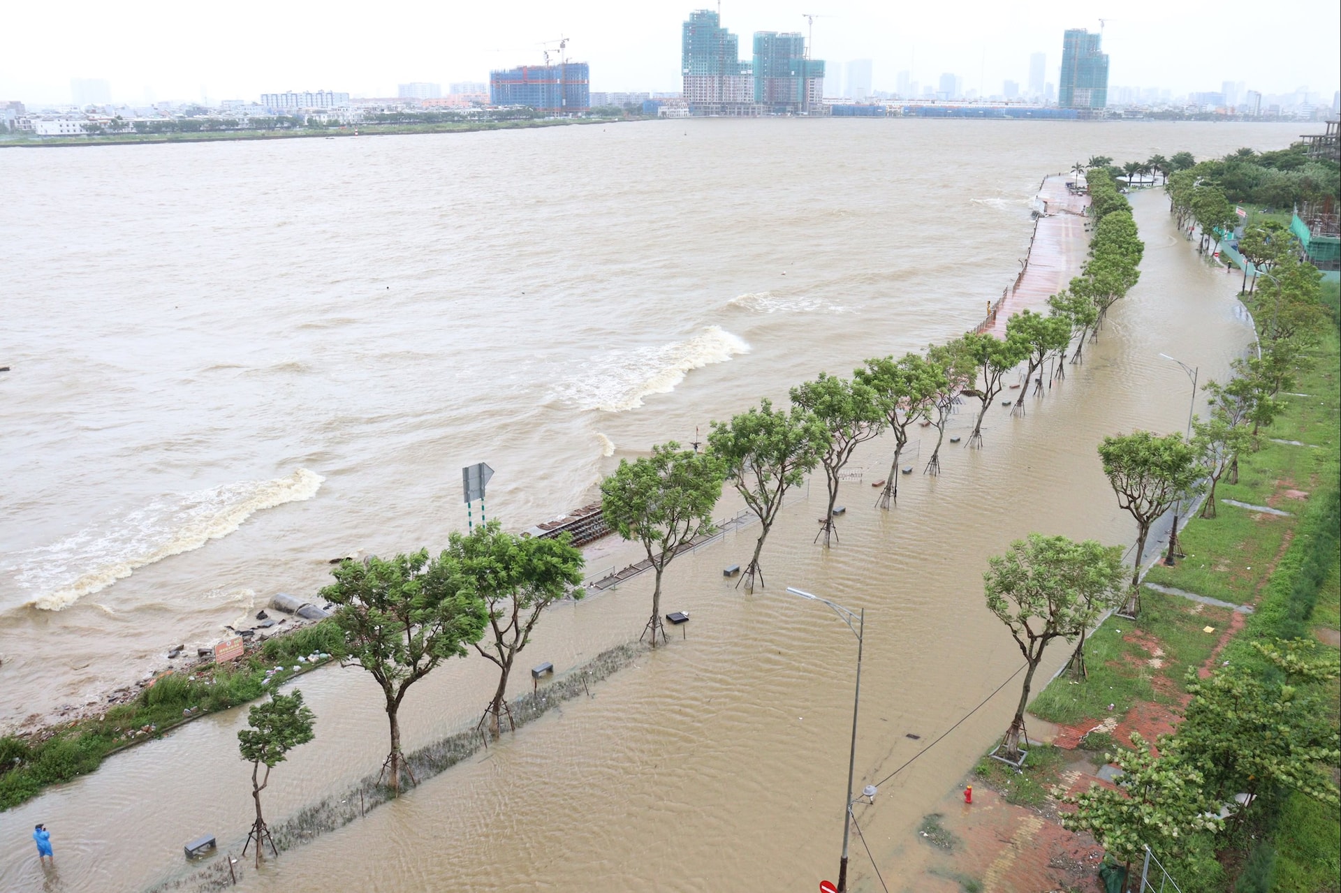
Due to the influence of the storm, the sea area of Da Nang city has strong winds of level 6-7, the area near the storm's eye has winds of level 8-9, gusts of level 10-11, waves 3-5m high, very rough seas.
Da Nang coastal area has storm surge from 0.4-0.8m high.
Due to the influence of storm circulation No. 12 combined with the strong strengthening of cold air, in the communes and wards on the mainland of Da Nang city, including the areas of Hai Chau, Hoa Khanh, Hai Van, Son Tra, Ngu Hanh Son, Hoi An, Dien Ban, Thang Binh, Tam Ky, Nui Thanh, the wind gradually increased to level 6, sometimes level 7, gusting to level 8-9.
Inland communes and wards, including Cam Le, Hoa Tien, Dai Loc, Tien Phuoc, and Que Son areas, have winds gradually increasing to level 5, gusting to level 7-8; Tra My, Kham Duc, Thanh My, Dong Giang, and Tay Giang have winds gradually increasing to level 4, sometimes level 5, gusting to level 6-7.
From the night of October 22 to 27, in localities of Da Nang city, there is a high possibility of widespread heavy rain lasting for many days with total rainfall at forecast points in Hai Van, Hoa Khanh, Hai Chau, Cam Le, Son Tra, Ngu Hanh Son, Hoi An, Hoa Tien, Dien Ban, Dai Loc commonly 500 - 700mm, in some places over 900mm.
Total rainfall in Thang Binh, Tam Ky, Nui Thanh is generally 450 - 650mm, some places over 800mm; Dong Giang, Tay Giang, Thanh My is generally 200 - 400mm, some places over 500mm; Que Son, Tien Phuoc, Kham Duc, Tra My is generally 500 - 750mm, some places over 850mm; Hoang Sa Special Zone is generally 100 - 200mm, some places over 300mm.
Beware of heavy rain over 200mm in 3 hours.
Heavy rains in the city are likely to last until the end of October 2025. There is a high risk of flash floods and landslides in mountainous areas, and flooding in low-lying and urban areas.
Localities need to prepare response plans for flood scenarios on rivers in Da Nang city that could reach alert level 2 to alert level 3, with some rivers above alert level 3.
Beware of the risk of thunderstorms, tornadoes and strong gusts of wind in the storm's circulation area, both before and during the storm's landfall.
Source: https://baodanang.vn/bao-so-12-di-chuyen-cham-de-phong-mua-lon-3308053.html


![[Photo] General Secretary To Lam receives the Director of the Academy of Public Administration and National Economy under the President of the Russian Federation](/_next/image?url=https%3A%2F%2Fvphoto.vietnam.vn%2Fthumb%2F1200x675%2Fvietnam%2Fresource%2FIMAGE%2F2025%2F12%2F08%2F1765200203892_a1-bnd-0933-4198-jpg.webp&w=3840&q=75)


Comment (0)