
 |
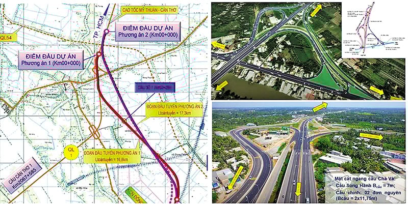
| Diagram showing two connection options for the Can Tho 2 Bridge Construction Investment Project and the approach roads at both ends of the bridge. |
A "dual" mission
Exactly two years after being assigned the task, last week, the My Thuan Project Management Board submitted Proposal No. 2109/PMUMT-KHTH requesting the Ministry of Construction to review and appraise the pre-feasibility study report for the Can Tho 2 Bridge and approach roads project.
According to the Road Network Planning for the period 2021-2030, with a vision to 2050, the Can Tho 2 Bridge Construction Project and its approach roads are the final piece of the Eastern North-South Expressway (CT.01) in the Mekong Delta region, connecting the My Thuan - Can Tho Expressway and the Can Tho - Ca Mau Expressway.
The investment in the construction of the new Can Tho 2 bridge also contributes to completing the transportation network in the region, connecting economic centers, new urban areas, and transportation hubs (airports, river ports, seaports, etc.) in the provinces and cities of Vinh Long, Can Tho, and Ca Mau.
In addition, the Can Tho 2 bridge is very likely to serve a "dual" purpose, acting as both a road bridge on the Eastern North-South Expressway and an important railway bridge on the Ho Chi Minh City - Can Tho railway line.
These are the reasons why early research and investment in the construction of the Can Tho 2 bridge is crucial, in order to synchronize and connect the Eastern North-South Expressway, the section from Ho Chi Minh City - Trung Luong - My Thuan - Can Tho - Ca Mau (the My Thuan - Can Tho section was opened to traffic at the end of 2023 and the Can Tho - Ca Mau expressway is under construction, expected to open to traffic at the end of 2025).
According to the research results of the joint venture of the Transport Design and Consulting Corporation (Tedi) and the Southern Transport Design and Consulting Joint Stock Company (Tedis), the Can Tho 2 Bridge and approach road construction project has its starting point connected to the Cha Va interchange, which is the end point of the My Thuan - Can Tho expressway project in Vinh Long province (approximately Km129+177 - CT01); and its end point connected to the IC2 interchange (intersecting with the road connecting National Highway 91 - Nam Song Hau), which is also the starting point of the Can Tho - Hau Giang - Ca Mau expressway project (approximately Km146+377 - CT01).
The total length of the project under study is approximately 17.2 km, of which the approach road and bridge on the Vinh Long side is 11.9 km long (located in Binh Minh, Cai Von, and Dong Thanh wards); the main bridge is approximately 1.1 km long; and the approach bridge and viaduct on the Can Tho side is 4.2 km long (located in Hung Phu ward).
“The most important highlight of the project is the Can Tho 2 bridge spanning the main channel of the Hau River. The bridge will have 6 lanes, with a planned main span of 450 meters and a cable-stayed structure,” said Mr. Diep Bao Tuan, Deputy Director of the My Thuan Project Management Board.
 |
Two investment options
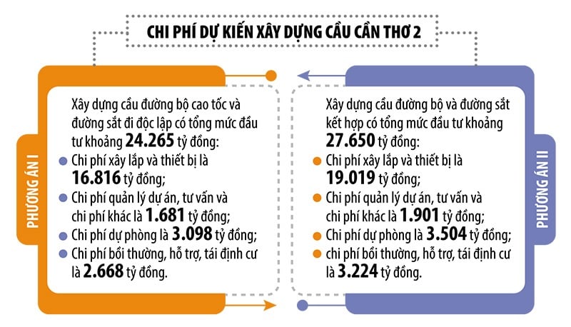
In the pre-feasibility study phase of the Can Tho 2 Bridge and approach roads project, the Tedi - Tedis consulting consortium studied two options: constructing the main Can Tho bridge independently and constructing the main Can Tho bridge in combination with a road and railway bridge.
For Option I - constructing separate road and railway bridges, the consulting unit proposed that, after passing the Chà Và interchange, the route would turn left towards the location of the Cần Thơ 2 bridge to cross the Hậu River (the Cần Thơ 2 bridge is located downstream, about 4.5 km from the existing Cần Thơ bridge). The bridge would run parallel to the left of the planned Ho Chi Minh City - Cần Thơ railway line along Highway 1A, approximately 280 m away.
After crossing the Hau River into Hung Phu ward, Can Tho city, the route continues along the planned centerline parallel to the elevated 3A arterial roads to pass through the Hung Phu industrial planning area and the South Can Tho urban area. The end point of the route will connect with the IC2 interchange, the starting point of the Can Tho - Hau Giang - Ca Mau expressway project.
Under Option II - a combined road and railway bridge, the approach route on the Vinh Long side is similar to Option I, but the road bridge will align with the centerline of the planned Ho Chi Minh City - Can Tho railway (road on the second level, railway on the first level).
After crossing the Hau River into Hung Phu ward (Can Tho City), the route follows the planned centerline of the elevated Highway 1A to pass through the Hung Phu industrial planning area and the South Can Tho urban area.
It is estimated that the total construction cost for the option of a separate highway and railway bridge is 33,989 billion VND (of which the railway bridge alone requires 9,724 billion VND), which is 6,339 billion VND higher than the option of a combined highway and railway bridge.
"If approved by the competent authorities, the Can Tho 2 Bridge Construction Investment Project will use state budget funds, with the expected commencement date in 2026 and the project substantially completed by 2030," a representative from the My Thuan Project Management Board proposed.
Source: https://baodautu.vn/hai-phuong-an-dau-tu-cau-can-tho-2-d341528.html

![[Image] National Assembly discusses the implementation of the socio-economic development plan.](https://vphoto.vietnam.vn/thumb/1200x675/vietnam/resource/IMAGE/2026/04/20/1776696707422_ndo_br_img-20260420-185419-jpg.webp)
![[Photo] General Secretary and President To Lam meets with National Assembly delegates from ethnic minorities.](https://vphoto.vietnam.vn/thumb/1200x675/vietnam/resource/IMAGE/2026/04/20/1776696701056_a1-bnd-8331-3342-jpg.webp)


Comment (0)