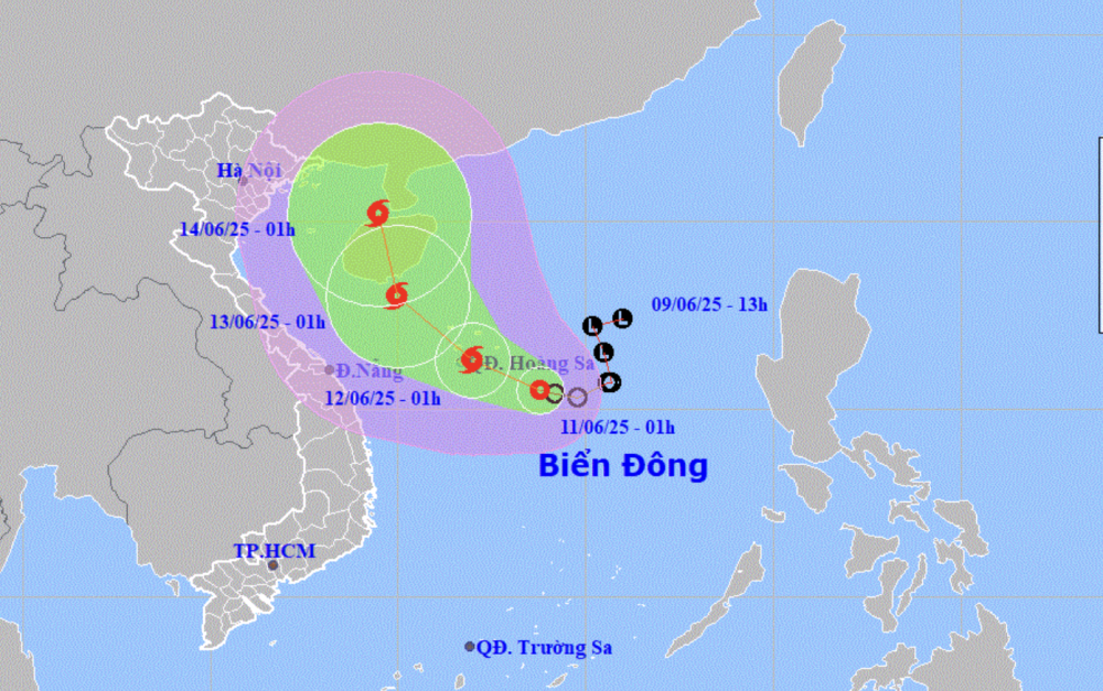
Forecast of location and direction of tropical depression at 1am June 11 (Photo: NCHMF)
According to the National Center for Hydro-Meteorological Forecasting at 1:00 a.m. on June 11, the center of the tropical depression was about 240km east-southeast of the Hoang Sa archipelago.
Currently, the strongest wind near the center of the tropical depression is level 7 (50-61km/h), gusting to level 9 and is moving slowly in a west-northwest direction at a speed of about 5-10km/h.
Forecast in the next 24 hours, the tropical depression will move in a west-northwest direction, then likely to strengthen into a storm (from morning to noon today).
This is likely to be the number 1 storm in the East Sea, and the first storm to operate in the northwest Pacific region.
At 1am tomorrow morning, the storm center will be over the Hoang Sa archipelago, with storm intensity of level 8-9, gusting to level 11.
During the next 24 to 48 hours, the storm will move northwest at a speed of about 10-15km/h and is likely to strengthen.
At 1:00 a.m. on June 13, the storm center was in the sea south of Hainan Island (China), the storm intensity was now level 9-10, gusting to level 13.
Over the next 48 to 72 hours, the storm is likely to change direction and move northwest at a speed of about 10km/h.
Due to the influence of a tropical depression that is likely to strengthen into a storm, in the northern East Sea (including the waters of the Hoang Sa archipelago), the northern area of the central East Sea will have thunderstorms and strong winds of level 6-7, later increasing to level 8-9, gusting to level 11, with waves 2.5-4.5m high.
In the south of the central East Sea area, the southern East Sea area (including the waters of Truong Sa archipelago) there is strong southwest wind level 6, sometimes level 7, gusting to level 8-9, waves from 2-4m high.
The offshore sea area from Quang Tri - Quang Ngai , the Gulf of Tonkin sea area is likely to have strong winds of level 7, in some places level 8, gusting to level 10, waves from 3-5m high.
Mr. Hoang Phuc Lam, deputy director of the National Center for Hydro-Meteorological Forecasting, said that with the current scenario of movement and the possibility of strengthening into a storm, the storm could cause heavy rain in the central provinces.
Specifically, today and tonight, in the South Central, Central Highlands and Southern regions, there will be moderate rain, heavy rain, and locally very heavy rain with common rainfall of 30-70mm, and in some places over 150mm.
From tonight to June 13, the Central Central region ( Quang Binh to Quang Ngai) will have moderate rain, heavy rain and thunderstorms, locally very heavy rain with common rainfall from 100-300mm, some places over 450mm. The Northern Central Highlands region will have from 70-150mm, some places over 200mm. Warning of the risk of local heavy rain over 200mm in 6 hours.
According to Mr. Lam, the development of storms and rains is still very complicated, depending on the direction of movement and impact of the tropical depression/storm./.
Proactively respond to tropical depressions that are likely to strengthen into storms On the evening of June 10, Deputy Prime Minister Tran Hong Ha signed a telegram from the Prime Minister on proactively responding to tropical depressions that are likely to strengthen into storms and floods. Accordingly, the Prime Minister requested the Chairmen of the People's Committees of coastal provinces and cities from Quang Ninh to Quang Ngai, Kon Tum and Gia Lai to proactively deploy response work appropriate to the specific situation in the locality, focusing on ensuring safety for ships and vehicles at sea. Proactively evacuate households in areas at high risk of landslides, flash floods, and deep flooding to safety. Have plans to ensure safety of key works, unfinished works, industrial parks, urban areas, residential areas and production activities in low-lying areas. The Prime Minister assigned the Ministry of Agriculture and Environment to proactively direct and urge localities to deploy appropriate response work to developments of tropical depressions, storms, floods and to direct work to ensure the safety of dykes, irrigation reservoirs and agricultural production. The Ministry of Industry and Trade directs the work of ensuring safety for industrial production and safety of hydroelectric dams, especially for small hydroelectric dams. |
According to Tuoi Tre Newspaper
Source: https://tuoitre.vn/hom-nay-ap-thap-nhiet-doi-manh-len-thanh-bao-so-1-nhieu-noi-mua-vua-den-mua-to-20250610234432017.htm
Source: https://baolongan.vn/hom-nay-ap-thap-nhiet-doi-manh-len-thanh-bao-so-1-nhieu-noi-mua-vua-den-mua-to-a196861.html



![[Photo] Celebration of the 65th Anniversary of the Establishment of Diplomatic Relations between Vietnam and Cuba](https://vphoto.vietnam.vn/thumb/1200x675/vietnam/resource/IMAGE/2025/9/1/0ed159f3f19344e497ab652956b15cca)
![[Photo] General Secretary receives heads of political party delegations from countries attending the 80th anniversary of our country's National Day](https://vphoto.vietnam.vn/thumb/1200x675/vietnam/resource/IMAGE/2025/9/1/ad0cb56026294afcae85480562c2e790)
![[Photo] Chu Dau Ceramics – Proud of Vietnamese identity at Exhibition A80](https://vphoto.vietnam.vn/thumb/1200x675/vietnam/resource/IMAGE/2025/9/1/c62ab2fc69664657b3f03bea2c59c90e)
![[Photo] Solemn reception to celebrate the 80th anniversary of the National Day of the Socialist Republic of Vietnam](https://vphoto.vietnam.vn/thumb/1200x675/vietnam/resource/IMAGE/2025/9/1/e86d78396477453cbfab255db1e2bdb1)
![[Photo] National Assembly Chairman Tran Thanh Man receives Cambodian Senate President Hun Sen](https://vphoto.vietnam.vn/thumb/1200x675/vietnam/resource/IMAGE/2025/9/1/7a90c9b1c1484321bbb0fadceef6559b)
![[Photo] People eagerly wait all night for the parade on the morning of September 2](https://vphoto.vietnam.vn/thumb/1200x675/vietnam/resource/IMAGE/2025/9/1/0cf8423e8a4e454094f0bace35c9a392)
























Comment (0)