
At 10:00 a.m. on October 27, the center of storm No. 6 was at about 16.3 degrees North latitude; 108.2 degrees East longitude, on the coastal area of Thua Thien Hue - Da Nang . The strongest wind near the center of the storm was level 9 (75-88 km/h), gusting to level 12.
Latest news on storm number 6: Already on the coastal area of Quang Tri - Quang Nam
According to the latest news from the National Center for Hydro-Meteorological Forecasting, due to the influence of storm No. 6, Con Co Island (Quang Tri) has strong winds of level 8, gusting to level 9; Cu Lao Cham Island (Quang Nam) has strong winds of level 8, gusting to level 10; Ly Son Island ( Quang Ngai ) has strong winds of level 6, gusting to level 7; Nam Dong (Thua Thien Hue) has strong winds of level 8, gusting to level 10; Cam Le (Da Nang) has strong winds of level 8, gusting to level 9.
Last night and this morning (October 27), the area from Ha Tinh to Da Nang had heavy to very heavy rain, total rainfall from 100-200mm, locally over 350mm.
At 10:00 a.m. on October 27 , the center of storm No. 6 was at about 16.3 degrees North latitude; 108.2 degrees East longitude, on the coastal area of Thua Thien Hue-Da Nang. The strongest wind near the center of the storm was level 9 (75-88 km/h), gusting to level 12. Moving southwest at a speed of 15-20 km/h.
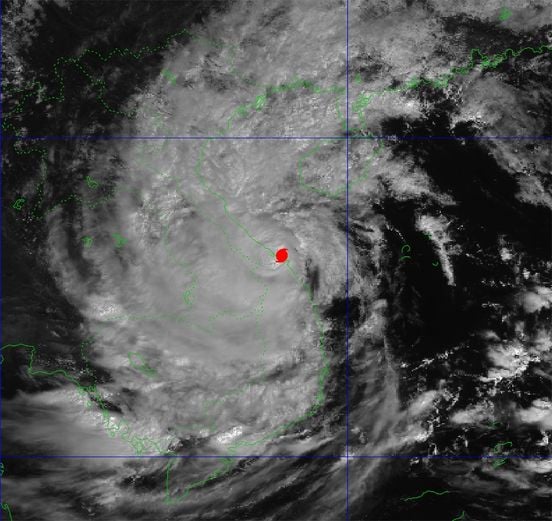
The movement of storm No. 6. Currently, storm No. 6 is located in the coastal areas of provinces from Thua Thien Hue to Da Nang. Photo: NCHMF.
Storm forecast ( next 12 to 48 hours):
Forecast time | Direction, speed | Location | Intensity | Danger zone | Disaster Risk Level (Affected Area) |
22h/27/10 | South Southwest 3-5km/h weakens into tropical depression | 15.9N-108.1E; on land in Thua Thien Hue, Quang Nam-Da Nang | Level 7, level 10 jerk | Latitude 15.0N-18.0N; West of Longitude 110.0E | Level 3: Central Central Coast; coastal mainland of Quang Tri-Quang Nam region |
10h/28/10 | Winter, 3-5km/h | 15.7N-108.5E; on the coastal area of Thua Thien Hue-Quang Ngai | Level 6, level 8 jerk | Latitude 14.5N-18.0N; West of longitude 110.0E | Level 3: Central Central Coast sea area; coastal mainland of Thua Thien Hue-Quang Nam area |
10h/29/10 | East, 5-10km/h, weakening into a low pressure area. | 15.6N-110.5E; in the sea southwest of Hoang Sa archipelago |
Warning of the impact of storm number 6
Due to the impact of storm No. 6, the sea areas of the provinces from Quang Binh to Quang Ngai (including Con Co Island, Cu Lao Cham, Ly Son) have strong winds of level 6-7, near the storm center of level 8-9, gusts of level 11, waves 3.0-5.0m high; very rough seas.
Storm surge in coastal areas: coastal areas from Quang Binh to Quang Nam provinces are likely to experience storm surges of 0.4-0.6m high.
Ships/boats operating in coastal areas from Quang Binh to Quang Ngai are likely to be affected by storms, whirlwinds, strong winds, and big waves.
High risk of landslides of sea dikes and embankments along the coast of provinces from Quang Tri to Quang Nam due to the impact of big waves and storm surges.
On land from Quang Binh to Quang Nam, there are strong winds of level 6-7, gusting to level 8-9; near the storm center, level 8-9, gusting to level 11.
From October 27 to the end of the night of October 28, in the area from Quang Binh to Quang Nam, there will be heavy to very heavy rain with total rainfall from 200-400mm, locally over 600mm. Warning of the risk of local heavy rain (>100mm/3 hours). The areas of Ha Tinh, Quang Ngai, Binh Dinh and the Northern Central Highlands will have heavy rain, locally very heavy rain with total rainfall from 100-200mm, some places over 250mm.
Source: https://danviet.vn/khan-tin-moi-nhat-ve-bao-so-6-khong-doi-huong-da-nam-o-ven-bien-thua-thien-hue-da-nang-20241027081046512.htm


![[Photo] National Assembly Chairman Tran Thanh Man visits Vietnamese Heroic Mother Ta Thi Tran](https://vphoto.vietnam.vn/thumb/1200x675/vietnam/resource/IMAGE/2025/7/20/765c0bd057dd44ad83ab89fe0255b783)


Comment (0)