

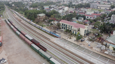
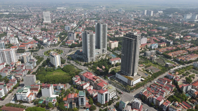
Panoramic view of the land on both banks of the Red River located in the general planning for construction along the Red River connecting 3 urban areas.
According to the Office of the People's Committee of Van Ban district, the General Planning Project for construction along the Red River connecting Pho Lu urban area (Bao Thang district) with Bao Ha urban area (Bao Yen district) and Tan An urban area (Van Ban district) has a total area of 3,650 hectares, located in the dynamic axis of the Red River.
The project focuses on developing a satellite urban system, industrial, agricultural and forestry production centers; forming resorts, entertainment, recreation and tourism services.
In particular, this place is located along the Lao Cai - Noi Bai highway, Sa Pa airport and the Lao Cai - Hanoi railway and the waterway along the Red River...
The planning ensures clear functional zoning boundaries, meeting the development requirements of each region and locality along both sides of the Red River in the south of Lao Cai province, bordering Van Yen district, Yen Bai province.
At the announcement ceremony, local delegates and people in the planned area expressed their high consensus with the Project and wished for the planning to be implemented soon.
Source
![[Photo] More than 17,000 candidates participate in the 2025 SPT Competency Assessment Test of Hanoi National University of Education](https://vphoto.vietnam.vn/thumb/1200x675/vietnam/resource/IMAGE/2025/5/17/e538d9a1636c407cbb211b314e6303fd)
![[Photo] Prime Minister Pham Minh Chinh chairs meeting on science and technology development](https://vphoto.vietnam.vn/thumb/1200x675/vietnam/resource/IMAGE/2025/5/17/ae80dd74c384439789b12013c738a045)
![[Photo] Readers line up to visit the photo exhibition and receive a special publication commemorating the 135th birthday of President Ho Chi Minh at Nhan Dan Newspaper](https://vphoto.vietnam.vn/thumb/1200x675/vietnam/resource/IMAGE/2025/5/17/85b3197fc6bd43e6a9ee4db15101005b)


![[Photo] Nearly 3,000 students moved by stories about soldiers](https://vphoto.vietnam.vn/thumb/1200x675/vietnam/resource/IMAGE/2025/5/17/21da57c8241e42438b423eaa37215e0e)


Comment (0)