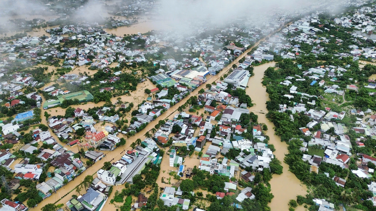
The phenomenon of simultaneous record-breaking floods in 3-5 basins is "extremely rare, almost never occurring in more than 50 years of observation," according to the Department of Hydrometeorology.
On the afternoon of November 23, the Department of Hydrometeorology ( Ministry of Agriculture and Environment ) reported on the flood in the South Central region. The total rainfall from 7:00 p.m. on November 15 to 7:00 p.m. on November 21 in the east of Dak Lak was generally 500-1,200 mm, with Song Hinh receiving 1,861 mm, Hoa My Tay receiving 1,575 mm, and Son Long receiving 1,363 mm. In the west of the province, the rain was 150-400 mm, with higher rainfall in some places such as M'Drak receiving 805 mm and Hoa Phong receiving 434 mm.
Gia Lai has widespread rain of 300-600 mm, some places have more rain such as Canh Lien 1,000 mm, An Quang 988 mm, Van Canh 927 mm; in the west of the province 100-300 mm, in Nghia An 498 mm, An Khe Lake 438 mm. Khanh Hoa also has particularly heavy rain, an average of 500-700 mm in the north, some places like Dai Lanh 1,071 mm, Khanh Hiep 1,002 mm, Son Thai 877 mm.

The Department of Hydrometeorology assessed that the rainfall in Son Hoa (Dak Lak) was 601 mm or Quy Nhon (Gia Lai) was 380 mm, exceeding historical records. Citing the classification of the World Meteorological Organization (WMO), the Department said that "these are rare events, almost impossible to accurately forecast quantitatively".
Combined with the fact that from October to mid-November 2025, rain in the South Central region was 120-200% higher than the average of many years, the land was saturated, so when entering the main rainy season, only 300-500 mm more rain was needed to form a big flood.
A series of rivers in the South Central region exceeded their historical flood peaks on January 15-21. Ky Lo River (Dak Lak) exceeded the 2009 record; Ba River exceeded 1993, Dinh Ninh Hoa River (Khanh Hoa) exceeded 1986. The flood peak on Ba River at Phu Lam station has an estimated recurrence period of 50 years (rare frequency).
The Department of Hydrometeorology assessed that simultaneous record-breaking floods in 3-5 basins are extremely rare, not within the normal flood calculation level, and accurate forecasting alone is not enough to prevent historic natural disasters.
| River | Station | Historic flood year | Compare flood peak 2025 with historical flood (cm) |
| Three | Cung Son | 1993 | >LLS 109 |
| Three | Phu Lam | 1993 | >LLS 19 |
| Kon | Thanh Hoa | 2013 | |
| Ninh Hoa Palace | Ninh Hoa | 1986 | >LLS 19 |
| Nha Trang | Dong Trang | 2009 | |
| Krong Ana | Giang Son | 1998 | < Length 266cm |
| Srepok | Ban Don | 1993 | < Length 106cm |
Statistics over the past 30 years show that major floods in the South Central region usually occur before November 15, but this one is later. This shows that traditional flood patterns are changing, and weather trends are becoming more extreme and unpredictable, according to the Department of Hydrometeorology.
Extreme weather events cause flooding
The cause of the heavy rain was attributed by the meteorological agency to a combination of extreme weather patterns. At high altitudes, strong disturbances in the easterly wind zone at an altitude of 1,500-5,000 m combined with very strong cold air created a zone of moisture convergence from low to high altitudes.
Water vapor from the East Sea is continuously transported to the mainland of the Central and Central Highlands, while the Truong Son terrain acts as a windbreak, stimulating strong convection and maintaining prolonged rain. Rainfall is commonly 800-1,700 mm in many places, far exceeding the natural drainage capacity.
In addition to weather factors, the topographic and hydrological characteristics of the Central region also increase the risk of major floods. Short river basins and steep slopes cause rainwater to concentrate quickly downstream, leading to flash floods, flash floods and floods rising rapidly in just a few hours. Water levels in the mainland rise, while the East Sea experiences large waves, 3-5 m waves, slowing down water drainage.
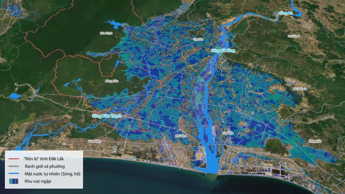
In addition, climate change has made extreme rainfall patterns stronger and more unpredictable, increasing the frequency of major floods in the past 10-15 years, with many stations recording rainfall exceeding historical levels of 1,000-1,700 mm/period.
Need to change forecasting and warning methods
Prof. Dr. Tran Thuc, Chairman of the Vietnam Hydrometeorological Association, said that in the context of climate change, the weather is increasingly extreme, it is necessary to change the forecasting and warning methods. With this flood, the rainfall area can be predicted, but the determination of the total rainfall at some local points is still incorrect, some places have higher rainfall than forecast. This is also a common limitation for tropical monsoon areas with strongly fragmented terrain, making it difficult to forecast heavy local rainfall in a narrow range.
Along with that, landslide warnings are still mainly at the "high risk in communes and wards" level without being able to locate specific landslide points (hillsides, small roads). The network of automatic monitoring stations in the upstream and deep mountainous areas (where flash floods originate) in the South Central region is still quite sparse, leading to a lack of real-time measurement data to warn of rapid flood rise.
Professor Thuc proposed three groups of solutions. Regarding technology and infrastructure, it is necessary to increase the density of the monitoring network by installing additional automatic rain gauge stations and specialized hydrological stations in the upstream areas and the "trough" areas of mobile waves in the South Central region; and promote the weather radar system in urban and mountainous areas to scan clouds and rain in detail, serving very short warnings.

Forecasting agencies need to build machine learning AI models based on local historical flood data to warn of urban flooding (such as Nha Trang, Phan Rang) and landslides in real time; complete large-scale disaster risk zoning maps (1:2000 or 1:5000) for key residential areas.
Regarding forecasting, Professor Thuc believes that it is necessary to switch to "impact-based forecasting". For example, instead of just reporting 200 mm of rain, the bulletin needs to specifically describe the consequences of such rain, how deep it will flood Road A, the risk of landslides at Pass B, and the water overflowing Dike C. This helps the government and people easily visualize the level of danger.
In addition, experts emphasized the need to tighten the inter-reservoir operation process in river basins in the South Central region (short and steep rivers). Flood discharge needs to be optimized with rainfall forecast data to avoid "flood on flood" downstream. Warning information also needs to be transmitted directly to people through multiple platforms, even when there is a power outage or local network congestion.
Source: https://baolaocai.vn/lu-nam-trung-bo-lon-nhat-trong-hon-50-nam-qua-post887429.html




















Comment (0)