
 |
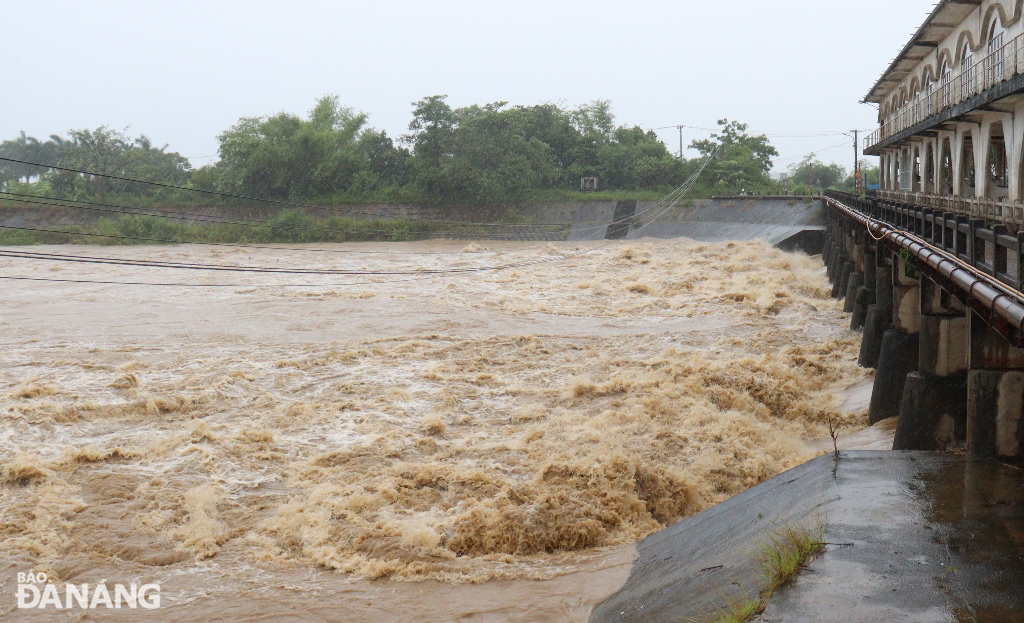
| Flood water levels on the Yen River at the An Trach dam remain high and continue to flow ashore, causing further flooding of some roads and residential areas. Photo: HOANG HIEP |
According to the forecast of the National Center for Hydro-Meteorological Forecasting, in the morning and on June 13, the area from Quang Binh to Hue will have heavy to very heavy rain with common rainfall of 50-130mm, some places over 250mm; Da Nang city and Ha Tinh, Quang Nam, Kon Tum provinces will have moderate rain, heavy rain, locally very heavy rain and thunderstorms with common rainfall of 20-50mm, some places over 120mm; warning of the risk of localized rain with intensity greater than 100mm in 6 hours.
From the night of June 13, heavy rain in the above areas decreased.
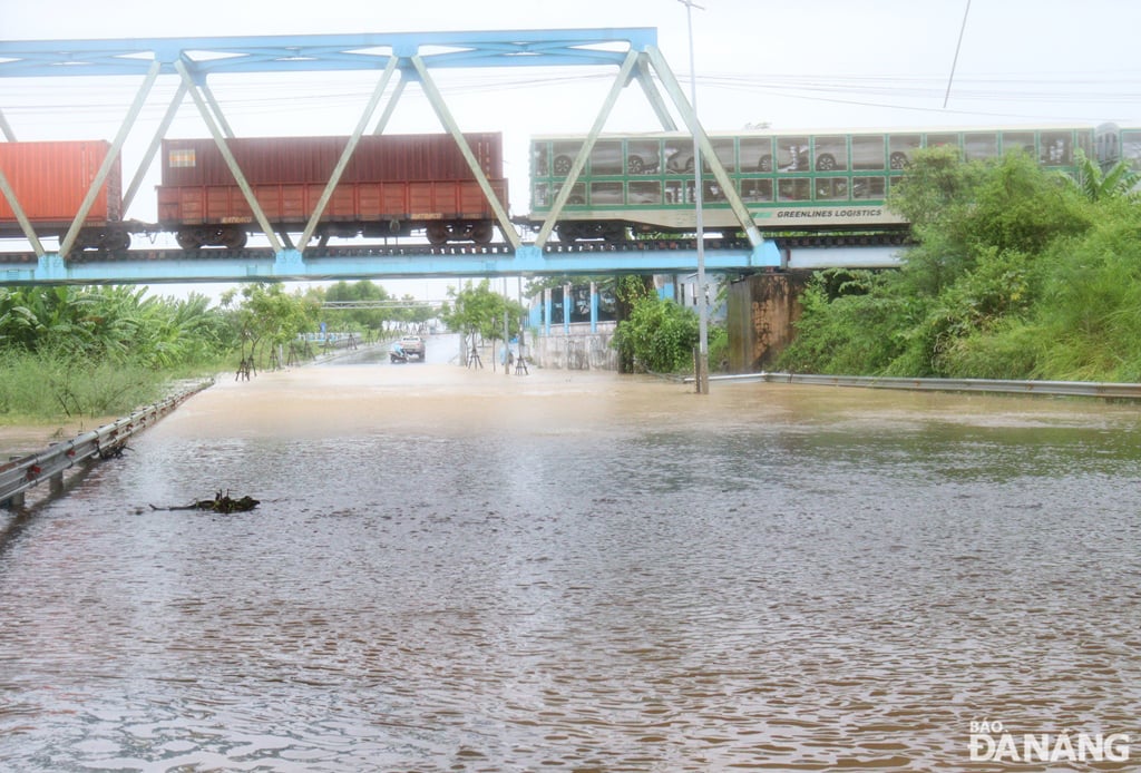 |
| The low-lying section of Thang Long Street was flooded nearly 0.7m deep in the early morning of June 13. Photo: HOANG HIEP |
There is a high to very high risk of flash floods, landslides, and land subsidence in provinces and cities from Ha Tinh to Quang Ngai and Kon Tum, including Hoa Vang district and Cam Le, Lien Chieu, Son Tra districts (Da Nang city) and Bac Tra My, Dai Loc, Dong Giang, Duy Xuyen, Hiep Duc, Nam Giang, Nam Tra My, Nui Thanh, Phu Ninh, Phuoc Son, Que Son, Tay Giang, Thang Binh, Tien Phuoc districts (Quang Nam province).
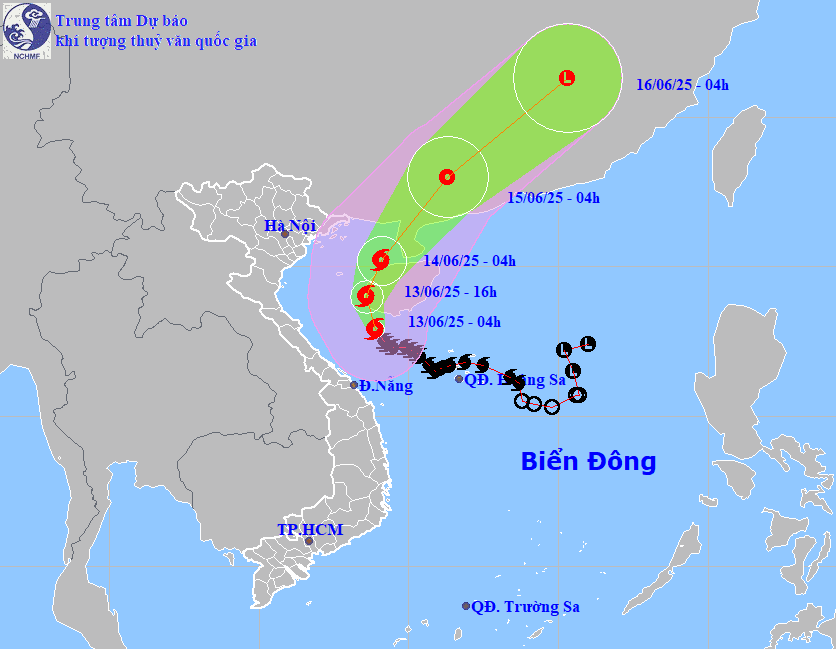 |
| Forecast map of storm No. 1's trajectory on the morning of June 13, 2025 (Source: National Center for Hydro-Meteorological Forecasting). |
At 4:00 a.m. on June 13, the center of storm No. 1 was at about 17.9 degrees north latitude, 108.9 degrees east longitude, in the sea south of Hainan Island (China) with the strongest wind at level 10, gusting to level 13; the storm moved west-northwest at a speed of about 10km/hour.
Forecast at 4:00 a.m. on June 14, the center of the storm is at about 20.2 degrees north latitude, 109.1 degrees east longitude, in the sea east of the northern Gulf of Tonkin with the strongest wind at level 9-10, gusting to level 13; the storm moves northwest, then turns northeast at a speed of about 10km/hour and weakens.
Due to the influence of storm No. 1, the northwestern area of the East Sea and offshore provinces and cities from Quang Tri to Quang Nam will have winds of level 6-8, near the storm center level 9-10, gusting to level 13; waves 3-5m high, near the storm center 4-6m, very rough seas.
The Gulf of Tonkin has strong winds of level 6-7, near the storm center of level 8-10, gusting to level 13; waves 2-4m high, especially in the southeast 3-5m, very rough seas.
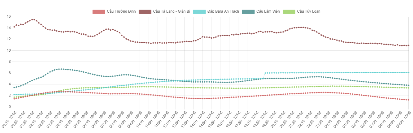 |
| Chart showing flood water levels of rivers at monitoring stations in Da Nang city on June 12 and 13, 2025. (Source: Da Nang City Flood Monitoring System) |
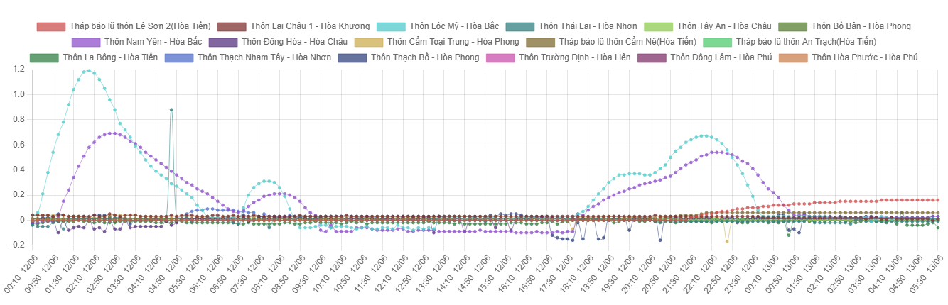 |
| Chart showing water levels at storm and flood towers on roads and residential areas in Hoa Vang district on June 12 and 13, 2025. (Source: Da Nang City Flood Monitoring System) |
HOANG HIEP
Source: https://baodanang.vn/xa-hoi/202506/lu-song-yen-duy-tri-muc-cao-nhieu-doan-duong-khu-dan-cu-con-ngap-lu-4008614/


Comment (0)