
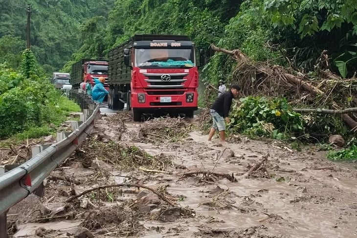
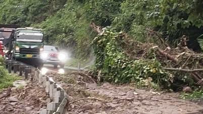
The West branch of Ho Chi Minh Road through Quang Tri has local landslides, causing traffic congestion - Photo: QUANG HA
On October 16, according to the Quang Tri Province Civil Defense Command, from 10:00 a.m. on October 15 to 10:00 a.m. on October 16, the province had moderate rain, and some places had very heavy rain. The average rainfall was 10 - 70mm; some places had especially heavy rain such as La To Hydropower Plant (Ta Rut Commune) 201mm, Huc (Khe Sanh Commune) 130mm, Ba Nang (Dakrong Commune) 130mm, Huong Loc (Tan Lap Commune) 95mm...
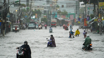
In Khe Sanh commune, heavy rain caused flooding at Van Ri spillway (km1 of provincial road 587), Ruong and Xa Re village spillway.
Floodwaters rose rapidly, causing temporary flooding in Van Ri village and forming strong currents in Ta Du and Huc Thuong villages.
Provincial Road 587 has many small landslides. Local authorities have evacuated 10 households with 46 people in Huc Thuong village to safety.
In Dakrong commune, Da Do spillway (Ra Lay village) and Chan Ro spillway (Chan Ro village) were flooded about 0.5m; Ba Long commune spillway was flooded 0.4m; La To, Huc Nghi and Ta Rut 1 spillway (Ta Rut commune) were flooded 0.3 - 0.4m.
In particular, on the West branch of Ho Chi Minh road, passing through Ta Rut commune, from km282+500 to km283+210, two large landslides appeared, with rocks, soil and forest trees spilling onto the road, causing local congestion.
Landslides caused local traffic congestion, trucks lined up hundreds of meters long and waited to pass the landslides.
Police and road management agencies were present in time to direct traffic, fix the problem, and ensure traffic safety. In addition, along the route from Dakrong suspension bridge to La Lay and Ta Rut communes, many small landslides were recorded, which are currently being warned and controlled.
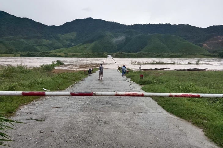
Ba Long commune's overflow bridge is flooded, cutting off access to some villages - Photo: QUANG HA
In Lam Thuy area (Kim Ngan commune) - upstream of Long Dai river, heavy rain from early morning caused landslides at km23, km25 of Highway 10 and km133 of Ho Chi Minh Highway West branch.
Mountainous areas are advised to closely monitor the development of floods and rains, evacuate people in areas at risk of landslides, and not allow people and vehicles to pass through overflow tunnels when water levels rise.
Source: https://tuoitre.vn/mua-lon-gay-sat-lo-duong-ho-chi-minh-ngap-cuc-bo-o-vung-nui-quang-tri-20251016113447749.htm

![[Photo] General Secretary To Lam attends the 18th Hanoi Party Congress, term 2025-2030](https://vphoto.vietnam.vn/thumb/1200x675/vietnam/resource/IMAGE/2025/10/16/1760581023342_cover-0367-jpg.webp)

![[Photo] Nhan Dan Newspaper launches “Fatherland in the Heart: The Concert Film”](https://vphoto.vietnam.vn/thumb/1200x675/vietnam/resource/IMAGE/2025/10/16/1760622132545_thiet-ke-chua-co-ten-36-png.webp)


![[Photo] Nhan Dan Newspaper launches “Fatherland in the Heart: The Concert Film”](https://vphoto.vietnam.vn/thumb/402x226/vietnam/resource/IMAGE/2025/10/16/1760622132545_thiet-ke-chua-co-ten-36-png.webp)


![[Video] TripAdvisor honors many famous attractions of Ninh Binh](https://vphoto.vietnam.vn/thumb/402x226/vietnam/resource/IMAGE/2025/10/16/1760574721908_vinh-danh-ninh-binh-7368-jpg.webp)


Comment (0)