
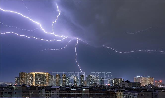
Between 2 PM and 4 PM on October 16th, inner-city wards of Hanoi such as Long Bien, Phuc Loi, Linh Nam, Viet Hung, Bo De, Vinh Hung, etc., will experience rain, showers, and thunderstorms. Afterwards, the thunderstorm area may expand to wards in the central area of Hanoi, with the possibility of tornadoes, lightning, hail, and strong gusts of wind during the thunderstorms.
Level 1 natural disaster risk warning due to tornadoes, lightning, and hailstorms.
Given the current weather patterns, Nguyen Van Huong, Head of the Weather Forecasting Department at the National Center for Hydro-Meteorological Forecasting, warned that thunderstorms, tornadoes, lightning, and strong gusts of wind pose a potential risk to people's lives and property. Tornadoes often occur alongside strong thunderstorms. When thunderstorm warnings are issued, people should seek shelter in safe, sturdy buildings.
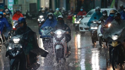
In addition, from noon on October 16th to noon on October 18th, the area from Quang Tri to Quang Ngai experienced moderate to heavy rain and thunderstorms with rainfall amounts generally ranging from 70-150mm, with some areas experiencing very heavy rain exceeding 350mm, and in Hue city in some localized areas exceeding 500mm.
Warning of risk of heavy rainfall exceeding 200mm/3h.
From noon on October 18th to noon on October 19th, the area from Quang Tri to Quang Ngai experienced moderate to heavy rain and thunderstorms with rainfall amounts generally ranging from 50-100mm, and locally very heavy rain in some areas.
150mm. This heavy rainfall is likely to continue.
The risk level for natural disasters due to heavy rain, tornadoes, lightning, and hail is level 1.
"Localized heavy rainfall is due to the influence of cold air combined with easterly wind disturbances and topographical factors. Areas needing to be vigilant during thunderstorms may experience tornadoes, lightning, hail, and strong gusts of wind," noted Mai Van Khiem, Director of the National Center for Meteorological and Hydrological Forecasting.
Heavy rainfall is likely to cause flooding in low-lying areas, urban and industrial zones; flash floods on small rivers and streams, and landslides on slopes (real-time warning information on flash flood and landslide risk areas is provided online on the website of the National Meteorological and Hydrological Service at: https://luquetsatlo.nchmf.gov.vn and in separate flash flood and landslide warning bulletins).
In addition, the National Center for Hydro-Meteorological Forecasting warns that from now until approximately 5:40 PM, there is a risk of flash floods and landslides in the provinces of Quang Ngai and Khanh Hoa.
Specifically, accumulated rainfall ranges from 20-40mm, with some areas exceeding 80mm. There is a warning of flash floods on small rivers and streams, and landslides on slopes in the following communes and wards: Ba Dinh, Ba Gia, Ba To, Ba To, Ba Vi, Ba Xa, Binh Chuong, Binh Minh, Ca Dam, Dang Thuy Tram, Dong Tra Bong, Khanh Cuong, Kon Plong, Duc Pho, Son Ha, Son Linh, Son Thuy, Tay Tra Bong, Tra Bong, Truong Giang (Quang Ngai province); Bac Ninh Hoa, Dien Dien, Nam Ninh Hoa, Tan Dinh, Tay Ninh Hoa; Dien Khanh, Dien Lac, Hoa Tri, Bac Nha Trang, Dong Ninh Hoa, Hoa Thang, Nam Nha Trang, Nha Trang, Ninh Hoa, Tay Nha Trang, Suoi Dau, Suoi Hiep, Trung Khanh Vinh, Van Hung (Khanh Hoa province).
Level 1 risk of natural disasters due to flash floods, landslides, and land subsidence caused by heavy rain or runoff.
Flash floods and landslides can have very serious impacts on the environment, threatening people's lives; causing localized traffic congestion, affecting the movement of vehicles; destroying public and economic infrastructure, causing damage to production and socio-economic activities.
The meteorological and hydrological agency recommends that local authorities pay attention to reviewing bottlenecks and vulnerable locations in the area to take preventive and response measures.
Source: https://baotintuc.vn/xa-hoi/canh-bao-dong-kem-loc-set-o-ha-noi-mua-lon-tu-quang-tri-den-quang-ngai-20251016145256493.htm

![[Image] Leaked images ahead of the 2025 Community Action Awards gala.](/_next/image?url=https%3A%2F%2Fvphoto.vietnam.vn%2Fthumb%2F1200x675%2Fvietnam%2Fresource%2FIMAGE%2F2025%2F12%2F16%2F1765882828720_ndo_br_thiet-ke-chua-co-ten-45-png.webp&w=3840&q=75)
![[Photo] Prime Minister Pham Minh Chinh receives Lao Minister of Education and Sports Thongsalith Mangnormek](/_next/image?url=https%3A%2F%2Fvphoto.vietnam.vn%2Fthumb%2F1200x675%2Fvietnam%2Fresource%2FIMAGE%2F2025%2F12%2F16%2F1765876834721_dsc-7519-jpg.webp&w=3840&q=75)
![[Photo] Prime Minister Pham Minh Chinh receives the Governor of Tochigi Province (Japan)](/_next/image?url=https%3A%2F%2Fvphoto.vietnam.vn%2Fthumb%2F1200x675%2Fvietnam%2Fresource%2FIMAGE%2F2025%2F12%2F16%2F1765892133176_dsc-8082-6425-jpg.webp&w=3840&q=75)

![[Live] 2025 Community Action Awards Gala](/_next/image?url=https%3A%2F%2Fvphoto.vietnam.vn%2Fthumb%2F1200x675%2Fvietnam%2Fresource%2FIMAGE%2F2025%2F12%2F16%2F1765899631650_ndo_tr_z7334013144784-9f9fe10a6d63584c85aff40f2957c250-jpg.webp&w=3840&q=75)


![[Photo] Prime Minister Pham Minh Chinh attends the Vietnam Economic Forum 2025](https://vphoto.vietnam.vn/thumb/402x226/vietnam/resource/IMAGE/2025/12/16/1765893035503_ndo_br_dsc-8043-jpg.webp)


Comment (0)