
According to the Provincial Hydrometeorological Station, the highest peak tide at the stations from November 10-14 appeared on November 10 (September 21st lunar month).
My Thuan station is 10cm higher than alert level III (BĐIII), Cho Lach station is 2cm higher than BĐII, Tra Vinh station is 5cm lower than BĐIII, the remaining stations are 9cm lower than BĐI to 4cm lower than BĐII. The highest historical peak tide observed at the stations so far: My Thuan 226cm, Cho Lach 216cm, Tra Vinh 221cm, Ben Trai 204cm, My Hoa 196cm, An Thuan 197cm, Binh Dai 196cm, Cau Quan 215cm.
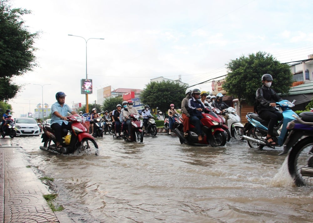 |
| High tides are likely to cause flooding in low-lying areas across the province. |
The possibility of flooding from November 10-11 is from 1-30cm, the deepest flooding depth will appear on November 10 from 1-30cm, some places will be flooded from 20-50cm deep (Binh Minh bus station), then gradually decrease (the flooding depth will gradually increase according to the rising water level of the tide). Warning information about natural disaster risk level: level 1-2.
High tides can cause flooding in low-lying areas across the province. Flooding can have negative impacts on the environment, road and waterway traffic activities, residential areas; fruit growing areas, livestock areas, aquaculture areas; especially upstream areas of the province; weak dyke areas - without and outside the dyke, sandbanks, islands, riverside areas, coastal areas...
Recommendation: Localities need to have plans to protect and reinforce the dike system, raise furniture and belongings, and proactively deal with flooding and landslides caused by high tides combined with upstream floods, rain and other factors.
News and photos: THAO LY
Source: https://baovinhlong.com.vn/thoi-su/202511/ngay-10-1111-trieu-cuong-co-the-gay-ngap-tu-1-30cm-49027c9/
![[Photo] Prime Minister Pham Minh Chinh chairs a meeting on housing policy and the real estate market.](https://vphoto.vietnam.vn/thumb/1200x675/vietnam/resource/IMAGE/2025/11/11/1762838719858_dsc-2107-jpg.webp)


![[Photo] Chu Noodles - the essence of rice and sunshine](https://vphoto.vietnam.vn/thumb/1200x675/vietnam/resource/IMAGE/2025/11/11/1762846220477_ndo_tl_7-jpg.webp)


![Dong Nai OCOP transformation: [Article 4] Reaching national standard products](https://vphoto.vietnam.vn/thumb/402x226/vietnam/resource/IMAGE/2025/11/11/1762825820379_4702-cac-san-pham-trai-cay-chung-nhan-ocop-nongnghiep-174649.jpeg)


![Dong Nai OCOP transition: [Article 3] Linking tourism with OCOP product consumption](https://vphoto.vietnam.vn/thumb/402x226/vietnam/resource/IMAGE/2025/11/10/1762739199309_1324-2740-7_n-162543_981.jpeg)


Comment (0)