
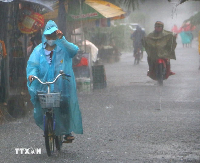
According to the National Center for Hydro-Meteorological Forecasting, from early morning to the night of August 22, the mountainous areas of the North will have moderate rain, heavy rain and thunderstorms with common rainfall of 30-60mm, locally very heavy rain over 150mm.
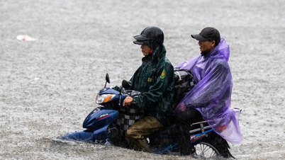
Last night and early this morning (August 22), the mountainous and midland areas of the North had rain, moderate rain and scattered thunderstorms, locally heavy to very heavy rain; the Southern region had locally heavy rain.
Rainfall from 7pm on August 21 to 3am on August 22 was over 60mm in some places such as: Quang Ngan station (Tuyen Quang) 152.6mm, Tran Thinh station (Lao Cai) 80mm, Van Ho station (Son La) 73.8mm, Nam Hang station (Lai Chau) 61.4mm, Pham Van Coi station ( Ho Chi Minh City) 67.8mm...
In addition, on the day and night of August 22, other places in the North, Thanh Hoa, the area from Quang Tri to Quang Ngai , the Central Highlands and the South will have scattered showers and thunderstorms with rainfall of 10-30mm, locally heavy rain over 70mm. Warning of the risk of heavy rain (over 100mm/3 hours).
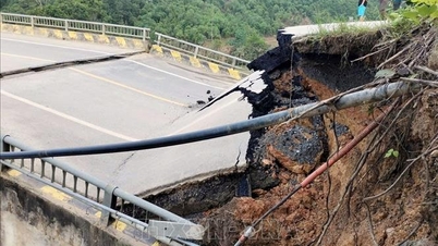
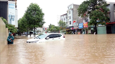
Heavy rains are likely to cause flooding in low-lying areas, urban and industrial areas; flash floods on small rivers and streams, landslides on steep slopes (real-time warning information on areas at risk of flash floods and landslides is provided online on the website of the Department of Hydrometeorology at: https://luquetsatlo.nchmf.gov.vn and in a separate bulletin warning of flash floods and landslides). During thunderstorms, there is a possibility of tornadoes, lightning, hail and strong gusts of wind.
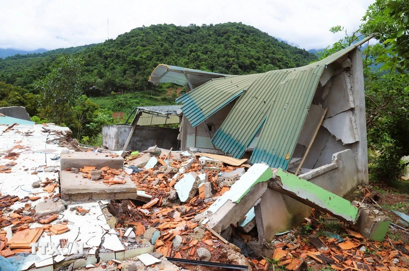
Risk of landslides and flash floods in many localities
In the past 6 hours (from 11pm on August 21 to 5am on August 22), the provinces of Son La, Lao Cai, Tuyen Quang, Cao Bang, Thai Nguyen and Phu Tho had moderate to heavy rain such as: Quang Ngan 195mm (Tuyen Quang); Van Ho 72mm (Son La); Bang Luan 60mm (Phu Tho); Chan Thinh 85mm (Lao Cai); Nam Quang2 46mm (Cao Bang); Yen Duong 32mm (Thai Nguyen)...
In the next 3-6 hours, the above provinces will continue to have rain with common accumulated rainfall as follows: Son La, Phu Tho, Lao Cai, Cao Bang, Thai Nguyen provinces from 10-30mm, some places over 70mm; Tuyen Quang province will have rain with common accumulated rainfall from 30-60mm, some places over 120mm.
Therefore, there is a risk of flash floods on small rivers and streams, landslides on steep slopes in many communes/wards: Doan Ket, Muong Bu, Thao Nguyen Ward, Van Son Ward, Ta Xua, Van Ho, Xim Vang (Son La); Bang Luan, Chan Mong, Chi Dam, Dan Thuong, Doan Hung, Ha Hoa, Hien Luong, Hoang Cuong, Quang Yen, Son Luong, Tay Coc, Thanh Ba, Van Lang, Vinh Chan, Yen Ky (Phu Tho).
Communes/wards: Chan Thinh, Che Tao, Nam Co, Pung Luong, Tu Le; Cam Nhan, Gia Hoi, Hanh Phuc, Mau A, Mo Vang, Cau Thia Ward, Nam Cuong Ward, Nghia Lo Ward, Trung Tam Ward, Phinh Ho, Phong Du Thuong, Quy Mong, Son Luong, Tan Hop, Thac Ba, Tram Tau, Tran Yen, Van Chan, Xuan Ai (Lao Cai).
Communes/wards: Thuong Son, Vi Xuyen, Viet Lam; Cao Bo, Nhu Khe, An Tuong Ward, Minh Xuan Ward, Thuan Hoa, Thuong Lam, Tung Ba; Bac Me, Bach Xa, Bang Hanh, Binh An, Binh Ca, Binh Xa, Can Ty, Chiem Hoa, Dong Tam, Du Gia, Duong Hong, Duong Thuong, Giap Trung, Ham Yen, Hoa An, Hong Son, Hung An, Hung Loi, Kien Dai, Kien Thiet, Kim Binh, Lam Binh, Lien Hiep, Linh Ho, Lung Phin, Lung Tam, Mau Due, Minh Quang, Minh Son, Minh Thanh, Na Hang, Nam Dich, Ngoc Duong, Ngoc Long, Ha Giang Ward 1, Ha Giang Ward 2, My Lam Ward, Nong Tien Ward, Phu Linh, Phu Luu, Quan Ba, Son Duong, Sung Mang, Tan An, Tan My, Tan Thanh, Tan Trao, Tat Nga, Thai Binh, Tri Phu, Trung Son, Truong Sinh, Yen Cuong, Yen Hoa, Yen Lap, Yen Minh, Yen Nguyen, Yen Phu (Tuyen Quang).
Communes/wards: Ba Be, Cho Don, Dong Phuc, Kim Phuong, Nam Cuong, Nghia Ta, Quang Bach, Thuong Minh, Yen Phong, Yen Thinh (Thai Nguyen); Bao Lam, Ly Bon, Nam Quang, Quang Lam, Yen Tho (Cao Bang).
Unseasonal rain in Vi Thanh city, Hau Giang province. (Photo: Duy Khuong/VNA) Specific weather in different areas
- Northwest region is cloudy with moderate rain, heavy rain and thunderstorms, locally very heavy rain. Light wind. During thunderstorms, there is a possibility of tornadoes, lightning, hail and strong gusts of wind. Temperature from 23-26 degrees Celsius, some places below 23 degrees Celsius; highest 29-32 degrees Celsius.
- The Northeast region is cloudy, with scattered showers and thunderstorms during the day; scattered showers and thunderstorms at night, with some heavy rain in some places. In the mountainous areas, it is cloudy with moderate rain, heavy rain and thunderstorms, and very heavy rain in some places. Southeast to South wind level 2-3. During thunderstorms, there is a possibility of tornadoes, lightning, hail and strong gusts of wind. Temperatures range from 24-27 degrees Celsius, with some places below 24 degrees Celsius; highest at 30-33 degrees Celsius, with some places below 30 degrees Celsius in the mountainous areas.
- From Thanh Hoa to Hue , sunny days; scattered showers and thunderstorms in the afternoon and evening, with heavy rain in some places; scattered showers and thunderstorms at night. During thunderstorms, there is a possibility of tornadoes, lightning, hail and strong gusts of wind. Temperatures range from 24-27 degrees Celsius, with the highest reaching 31-34 degrees Celsius.
- The South Central Coast has scattered showers and thunderstorms, locally heavy rain (rain concentrated in the afternoon and evening). Southwest wind level 2-3. During thunderstorms, there is a possibility of tornadoes, lightning, hail and strong gusts of wind. Temperatures range from 23-26 degrees Celsius, highest from 30-33 degrees Celsius, some places above 33 degrees Celsius.
- The Central Highlands has scattered showers and thunderstorms, locally heavy rain (rain concentrated in the afternoon and evening). Southwest wind level 2-3. During thunderstorms, there is a possibility of tornadoes, lightning, hail and strong gusts of wind. Temperature from 20-23 degrees Celsius, highest 27-30 degrees Celsius.
- The South also has scattered showers and thunderstorms, locally heavy rain (rain concentrated in the afternoon and night). Southwest wind level 2-3. During thunderstorms, there is a possibility of tornadoes, lightning, hail and strong gusts of wind. Temperature from 24-27 degrees Celsius, highest 29-32 degrees Celsius.
- Hanoi has occasional showers and thunderstorms, with intermittent sunshine during the day. Southeast wind level 2-3. During thunderstorms, there is a possibility of tornadoes, lightning and strong gusts of wind. Temperatures range from 25-27 degrees Celsius, with the highest at 31-33 degrees Celsius.
- Ho Chi Minh City has scattered showers and thunderstorms, locally heavy rain (rain concentrated in the afternoon and night). Southwest wind level 2-3. During thunderstorms, there is a possibility of tornadoes, lightning, hail and strong gusts of wind. Temperature from 23-25 degrees Celsius, highest 30-32 degrees Celsius.
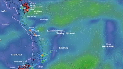
At sea, on the day and night of August 22, the eastern sea area of the North and Central East Sea, the southern East Sea area (including the Truong Sa special zone); the sea area from Gia Lai to Ca Mau, from Ca Mau to An Giang and the Gulf of Thailand will have scattered showers and thunderstorms. During thunderstorms, there is a possibility of tornadoes, strong gusts of wind of level 6-7 and waves of 1-2m high.
In addition, in the eastern sea area of the North East Sea, from the night of August 22, the wind will gradually increase to level 5, sometimes level 6, gusting to level 7-8. The sea will be rough. Waves will be 1.5-2.5m high. All vessels operating in the above areas are at risk of being affected by tornadoes and strong gusts of wind.
Source: VNA
Source: https://baophutho.vn/ngay-22-8-bac-bo-van-mua-to-nguy-co-lu-quet-va-sat-lo-dat-o-nhieu-dia-phuong-238365.htm
![[Photo] Ho Chi Minh City is brilliant with flags and flowers on the eve of the 1st Party Congress, term 2025-2030](https://vphoto.vietnam.vn/thumb/1200x675/vietnam/resource/IMAGE/2025/10/10/1760102923219_ndo_br_thiet-ke-chua-co-ten-43-png.webp)

![[Photo] General Secretary attends the parade to celebrate the 80th anniversary of the founding of the Korean Workers' Party](https://vphoto.vietnam.vn/thumb/1200x675/vietnam/resource/IMAGE/2025/10/11/1760150039564_vna-potal-tong-bi-thu-du-le-duyet-binh-ky-niem-80-nam-thanh-lap-dang-lao-dong-trieu-tien-8331994-jpg.webp)


![[Photo] Opening of the World Cultural Festival in Hanoi](https://vphoto.vietnam.vn/thumb/1200x675/vietnam/resource/IMAGE/2025/10/10/1760113426728_ndo_br_lehoi-khaimac-jpg.webp)


Comment (0)