
Increase production, improve water supply for people
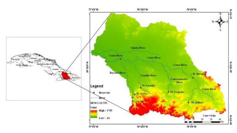
The Cauto River Basin – Cuba’s longest river and of great significance to national food security – is facing unprecedented challenges due to the dual impact of climate change and socio-economic development. With a length of more than 340 km, originating in the Sierra Maestra range and flowing through four key agricultural provinces: Granma, Holguin, Santiago de Cuba and Las Tunas, this basin provides irrigation and domestic water for about 10% of the country’s population. However, in recent decades, this area has repeatedly experienced severe droughts, especially during the dry season from November to April every year. Despite an average rainfall of up to 1,200 mm per year, the degraded water storage and distribution system has caused the region to frequently suffer from severe water shortages.
In the context of very limited meteorological measurement data in Cuba, the research team led by Dr. Tran Anh Phuong and Master Tran Bao Chung, Institute of Water Resources Science, Ministry of Natural Resources and Environment (now the Ministry of Agriculture and Environment ) conducted "Research on the current status of surface water resources and forecast of saline intrusion in the Cauto River basin as a basis for proposing solutions to increase rice production and improve water supply for people", code NDT.100.CU/21. The task was implemented within the framework of the Cooperation Protocol with Cuba. The task funding was sponsored through the Office of National Science and Technology Programs, Ministry of Science and Technology (now the National Science and Technology Development Fund, Ministry of Science and Technology).
The mission uses high-resolution CHIRPS satellite rainfall data, calibrated with data from on-site stations, to analyze the spatial and temporal characteristics of droughts across the basin. By calculating the drought stress index (SPI) at three-, six-, and nine-month intervals over the period 1981–2023, the team has determined the frequency, intensity, and extent of drought events.
The results showed that the average drought frequency in the whole region ranged from 15 to 17% of the total time, in which the most severe droughts occurred in 1988, 1992, 1998 and especially in 2004–2005 with the SPI index falling below -2, reflecting extreme drought conditions.
It is noteworthy that droughts not only occur frequently but also tend to increase in severity during the dry season. Statistical analysis using the Mann-Kendall method shows a gradual decrease in the SPI index during the dry months, while the rainy months tend to be wetter - a clear demonstration of changes in rainfall regimes under the impact of global climate change.
Not only stopping at identifying droughts, the research team also deeply analyzed the differences according to terrain, in which the downstream plain areas suffered from droughts that lasted longer and were significantly more intense than the mountainous areas upstream.
To have a more comprehensive view of the current state of water resources, the authors developed an integrated model between SWAT (hydrological simulation) and WEAP (water resource allocation) to fully assess the supply - demand - water balance cycle across the basin, both at present and under scenarios up to 2050.
Simulation results show that the current total water demand of the Cauto River Basin is about 1,194 million cubic meters per year, of which 96% is for agriculture - mainly rice and upland crops. Water demand for domestic use and livestock accounts for only 3% and 1%, respectively. However, by the middle of the 21st century, the total water demand is forecast to increase to 1,394 million cubic meters per year (an increase of 16.6%), due to the expansion of cultivated areas in line with the development of the agricultural economy, while the population tends to decrease slightly.
.")
On the other hand, water supply will not only not increase but also decrease slightly (about 2.5%) due to stronger evaporation, especially during the rainy season - an inevitable consequence of the rising temperature trend. As a result, the water imbalance will become more serious, with the total deficit increasing from 172 million cubic meters at present to 262 million cubic meters in 2050, equivalent to an increase of more than 52%. The areas most at risk of water shortage are the SB3 and SB12 sub-basins in the Bayamo region - where rice production is concentrated and water demand is very high.
Using calibrated satellite data to replace sparse measurement networks
Based on these results, the research team proposed a series of highly applicable solutions for water resources management and climate change adaptation in Cuba. First of all, it is necessary to continue to expand the use of integrated models such as SWAT-WEAP combined with CHIRPS, IMERG, ERA5 satellite data... to build a decision support system for management agencies. This system can help forecast droughts early, optimize water allocation and adjust crop plans in accordance with actual supply capacity in real time. In addition, prioritizing domestic water and livestock in resource allocation must be ensured in all scenarios. The crop structure also needs to be reviewed, limiting the planting of crops that require large amounts of water in areas with high potential for shortage, especially rice in the SB3, SB12, SB4 sub-basins of the Bayamo region.
One of the highlights of the study is the successful use of calibrated satellite data to replace sparse measurement networks, thereby opening up an efficient and low-cost approach for developing countries like Cuba. These results not only help to better manage Cuba’s own water resources, but can also be applied to many other river basins around the world facing similar challenges.
This groundbreaking research once again demonstrates the great potential of data science and modeling in solving global environmental problems, and recognizes the outstanding contributions of Vietnamese scientists in the field of international water resources management.
Source: https://nhandan.vn/nghien-cuu-giai-bai-toan-xam-nhap-man-tren-cac-luu-vuc-song-post925040.html


Comment (0)