
According to the Hai Phong City Hydrometeorological Station, on November 11, the city area continued to be affected by high tides. The highest water level in the coastal area of Hai Phong fluctuated from 390 - 400 cm, of which at Hon Dau station it was about 400 cm at 9:00 am, Bach Long Vi about 390 cm at 8:20 am.
High tides are likely to cause flooding of 0.5 - 0.7m in low-lying areas along the Bach Dang, Lach Tray, Cam, Moi and Thai Binh rivers, affecting crops, aquaculture and coastal traffic.
It is forecasted that in the next 24 - 48 hours, the Hai Phong sea area will continue to be affected by high tides. On the morning of November 12, the water level may reach 375 - 385 cm. Disaster risk level: level 1.
Prevent flooding in low-lying areas along rivers that affect people's rice and crops; affect flooded areas for aquaculture, traffic activities and some activities in coastal tourist areas.
Typhoon Fung Wong weakens

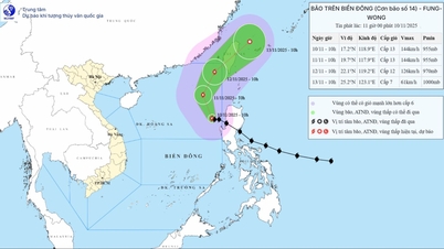
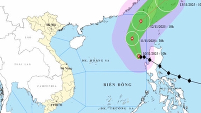
According to the National Center for Hydro-Meteorological Forecasting, at 4:00 a.m. on November 11, the center of storm Fung Wong was located at about 19.3 degrees North latitude, 118.1 degrees East longitude, in the eastern sea of the North East Sea. The strongest wind near the center of the storm was level 12 (118 - 133 km/h), gusting to level 15. The storm moved in a northwest direction at a speed of about 10 km/h.
It is forecasted that in the next 24 hours, the storm will move in a North-Northeast direction, traveling about 10-15 km per hour. At 4:00 a.m. on November 12, the center of the storm will be at about 22.2 degrees North latitude; 119.2 degrees East longitude, continuing over the northeastern part of the East Sea. The strongest wind near the center of the storm will remain at level 12, gusting to level 15.
At 4:00 a.m. on November 13, the storm center moved up to about 24.3 degrees North latitude; 122.2 degrees East longitude, located in the sea east of Taiwan (China). At this time, the storm tends to weaken gradually, the strongest wind speed decreased to level 7, gusting to level 9 and continued moving in the Northeast direction at a speed of about 15 km/hour.
Due to the influence of typhoon Fung Wong, the eastern sea area of the North East Sea has strong winds of level 7 - 9, the area near the eye of the storm has strong winds of level 10 - 12, gusting to level 15; waves are 4 - 7 m high, the area near the eye of the storm can reach 9 m, the sea is very rough. All ships operating in the dangerous area are at risk of being affected by strong winds, big waves, thunderstorms and whirlwinds.
Meteorological experts recommend that ships operating in the central and northern areas of the East Sea, especially in the Northeast, should regularly monitor weather forecasts, proactively stay away from dangerous areas, and ensure the safety of people and vehicles.
The meteorological agency also added that although storm Fung Wong will not directly affect mainland Vietnam, the storm's distant circulation may cause bad weather, showers and thunderstorms for the northern coastal areas in the coming days.
Source: https://baohaiphong.vn/nguy-co-ngap-vung-trung-ven-bien-526279.html

![[Photo] Prime Minister Pham Minh Chinh chairs a meeting on housing policy and the real estate market.](https://vphoto.vietnam.vn/thumb/1200x675/vietnam/resource/IMAGE/2025/11/11/1762838719858_dsc-2107-jpg.webp)


![Dong Nai OCOP transformation: [Article 4] Reaching national standard products](https://vphoto.vietnam.vn/thumb/402x226/vietnam/resource/IMAGE/2025/11/11/1762825820379_4702-cac-san-pham-trai-cay-chung-nhan-ocop-nongnghiep-174649.jpeg)


![Dong Nai OCOP transition: [Article 3] Linking tourism with OCOP product consumption](https://vphoto.vietnam.vn/thumb/402x226/vietnam/resource/IMAGE/2025/11/10/1762739199309_1324-2740-7_n-162543_981.jpeg)


Comment (0)