
Overview of Hoa Khanh commune road planning
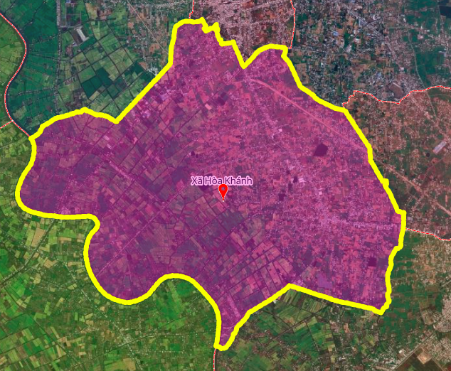
Hoa Khanh commune is one of 96 communes and wards of Tay Ninh province. In terms of geographical location, the north of Hoa Khanh commune borders Hiep Hoa, Hau Nghia and Duc Lap communes; the east borders My Hanh and Duc Hoa communes; the south borders Duc Hoa and Duc Hue communes; the west borders Duc Hue commune.
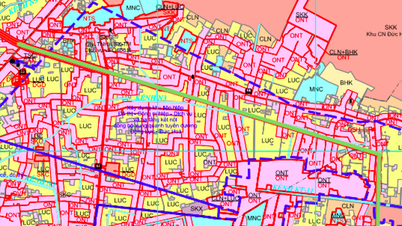
According to the land use planning adjustment map for the period 2021 - 2030 of Duc Hoa district, Long An province, Hoa Khanh commune will have 3 new roads marked in green on the planning map. The total length of these roads is estimated at about 16.5 km, forming a traffic network connecting the central areas and district boundaries.
Detailed analysis of 3 planned routes
1. Route parallel to Highway 02
This route is about 6 km long, running parallel to Highway 02 within Hoa Khanh commune. The starting point is near Hau Nghia Regional General Hospital, the end point is at Sa Ba Street (near Ba Dat Bridge). This route will create a secondary traffic axis parallel to the highway, improving connectivity between the medical area and the residential area west of the commune.
2. Route parallel to Provincial Road 823
With a length of about 6.5 km, this route runs parallel to Provincial Road 823. The starting point of the route is from Provincial Road 825 (roundabout section), the end point crosses the Vam Co Dong River. This is the longest route of the 3 planned routes, playing the role of connecting provincial roads and gateway bridges across the Vam Co Dong River.
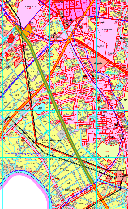
3. Route across Lang Ven canal
The shortest route of the three with a length of about 4 km, starting at Highway 02 (roundabout section) and ending across Lang Ven canal. This route creates a direct connection from the highway to the local canal system, supporting the development of agricultural areas and residents along the canal.
Technical specifications summary table
| STT | Route | Length | Starting point | End point | Nature |
|---|---|---|---|---|---|
| 1 | Parallel to Highway 02 | ~6 km | Near Hau Nghia Regional General Hospital | Sa Ba Street (near Ba Dat Bridge) | Secondary shaft |
| 2 | Parallel to Provincial Road 823 | ~6.5 km | Provincial Road 825 (roundabout) | Crossing the Dong Nai River | Inter-regional connection |
| 3 | Crossing Lang Ven canal | ~4 km | Highway 02 (roundabout) | Crossing Lang Ven canal | Internal connection |
Planning resources and important notes
The above routes are determined based on the land use planning adjustment map for the period 2021 - 2030 of Duc Hoa district, Long An province. The diagram in the article is drawn relatively based on this map. This is an important point to note because Hoa Khanh commune belongs to Tay Ninh province but the planning data is referenced from Long An.
People and investors need to follow the official approval documents from the competent authorities of Tay Ninh province to have the most accurate information on the planning and progress of the project.
Impact on the real estate market
The opening of 3 new routes with a total length of 16.5 km will create many opportunities and challenges for the real estate market of Hoa Khanh commune:
- Opportunity: Land plots along new routes, especially intersections with existing roads (Provincial Road 825, Highway 02) will increase in value due to improved connectivity.
- Risk: The planning is still in the adjustment phase, there is no official document from Tay Ninh province. Land buyers need to be careful about the law.
- Potential: The area across the Vam Co Dong River and Lang Ven Canal can be developed into new urban areas or high-tech agricultural zones.
Warning for investors
Project information may change according to the official planning adjustment of Tay Ninh province. Buyers need to verify the legality before deciding to invest. The figures on length and location of the route are for reference only from the planning map of Duc Hoa district, Long An province and may not accurately reflect the final planning of Tay Ninh province.
Source: https://baolamdong.vn/quy-hoach-3-tuyen-duong-moi-tai-xa-hoa-khanh-tay-ninh-tong-chieu-dai-165-km-404378.html
![[Photo] Visit Hung Yen to admire the "wooden masterpiece" pagoda in the heart of the Northern Delta](/_next/image?url=https%3A%2F%2Fvphoto.vietnam.vn%2Fthumb%2F1200x675%2Fvietnam%2Fresource%2FIMAGE%2F2025%2F11%2F21%2F1763716446000_a1-bnd-8471-1769-jpg.webp&w=3840&q=75)
![[Photo] General Secretary To Lam receives President of the Senate of the Czech Republic Milos Vystrcil](/_next/image?url=https%3A%2F%2Fvphoto.vietnam.vn%2Fthumb%2F1200x675%2Fvietnam%2Fresource%2FIMAGE%2F2025%2F11%2F21%2F1763723946294_ndo_br_1-8401-jpg.webp&w=3840&q=75)

![[Photo] President Luong Cuong receives Speaker of the Korean National Assembly Woo Won Shik](/_next/image?url=https%3A%2F%2Fvphoto.vietnam.vn%2Fthumb%2F1200x675%2Fvietnam%2Fresource%2FIMAGE%2F2025%2F11%2F21%2F1763720046458_ndo_br_1-jpg.webp&w=3840&q=75)

![[Photo] National Assembly Chairman Tran Thanh Man holds talks with President of the Senate of the Czech Republic Milos Vystrcil](/_next/image?url=https%3A%2F%2Fvphoto.vietnam.vn%2Fthumb%2F1200x675%2Fvietnam%2Fresource%2FIMAGE%2F2025%2F11%2F21%2F1763715853195_ndo_br_bnd-6440-jpg.webp&w=3840&q=75)


Comment (0)