
Development linked to new industrial zones
The High-tech zoning plan (excluding the area for implementing the Da Nang High-tech project), scale 1/2000, approved by the People's Committee in Decision No. 1317/QD-UBND dated June 24, 2024, determined that the planning area with research locations includes the wards of Hoa Khanh Bac, Hoa Hiep Bac, Hoa Hiep Nam (Lien Chieu district) and the communes of Hoa Lien, Hoa Son, Hoa Ninh (Hoa Vang district) with a total area of about 3,656 hectares.
In which, the North borders Cu De River; the South borders DT602 road; the East borders Nguyen Luong Bang road; the West borders the Western Belt Road, Da Nang High-Tech Park, and the Western Ecological subdivision.
The High-Tech Zone planning (excluding the area for implementing the Da Nang High-Tech project) has a total area of about 3,656 hectares.
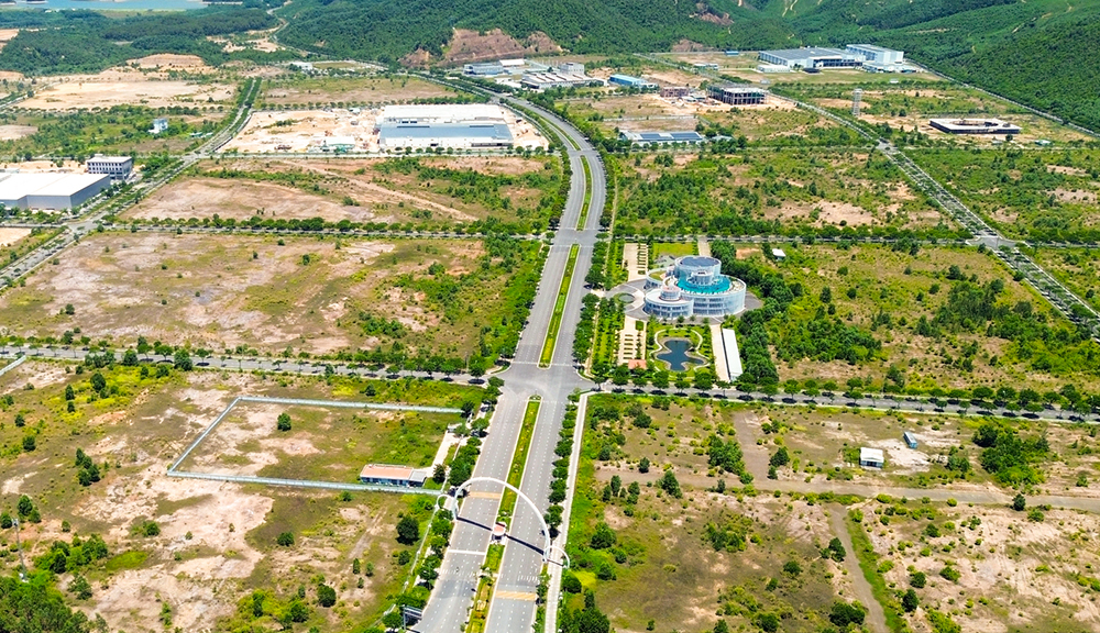
In terms of nature, the planning area will develop in conjunction with functional areas including new industrial parks (High-tech Auxiliary Zone, Concentrated Information Technology Zone No. 1, No. 2), Hoa Ninh Industrial Park, existing industrial parks, urban areas that have been and are being formed in Hoa Son, Hoa Lien, Hoa Hiep Nam, along with large public spaces, connecting with the ecological zone in the West and Cu De River in the North.
The planned population by 2030 is about 235,000 people. Of which, the permanent population is about 220,000 people; the converted population is about 15,000 people.
The High-Tech Zone according to the general planning project is divided into 15 residential units and 06 functional areas including 04 industrial parks; 01 industrial park, information technology and 01 cemetery.
Specifically, the Industrial Park 1 functional area has an area of about 295.4 hectares; in essence, this is the current Hoa Khanh Industrial Park, oriented towards an ecological industrial model that converts technology to suit the surrounding environment. Improving management and operation processes, innovating clean production technology, reusing waste and scrap...
The functional area of Industrial Park 2 has an area of about 49.4 hectares. This is part of the existing expanded Hoa Khanh Industrial Park and the existing Thanh Vinh Industrial Cluster, with a priority orientation for developing clean, environmentally friendly industries.
Industrial Park 3's functional area covers an area of about 106.1 hectares. This is part of the Hoa Khanh Industrial Park, expanding its current status, with the orientation to 2045 to transform into high-tech and environmentally friendly industry.
The functional area of Industrial Park 4 has an area of about 337.5 hectares; the converted population is about 5,000 people. In nature, this is the current concentrated Information Technology Park and the Auxiliary Area serving the Da Nang High-Tech Park project, which is being oriented to be converted into the Hoa Lien Industrial Cluster.
Industrial Park 5 functional area has an area of about 421 hectares. This will be the newly planned Hoa Ninh Industrial Park.
The Cemetery functional area has an area of about 154 hectares; this is the Hoa Ninh Cemetery.
The urban gateway is the high-tech zone overpass
In the zoning plan, regional highlights (not enjoying the incentives of urban highlights) are identified to orient the space, create characteristics and identify the area such as: Nguyen Tat Thanh extended - Nguyen Luong Bang intersection, Nguyen Tat Thanh extended - Western Belt 2 intersection, DT602 road intersection - Western Belt 2; commercial and service works along the extended Nguyen Tat Thanh road, the floating island area of Zone E Golden Hills, the area of high-rise commercial and service works in the new development area at Residential Unit No. 9 and the Trung Son Hill relic area (4-DTT1).
The master plan identifies the urban gateway to the North at the high-tech zone overpass. This area concentrates the main traffic routes connecting from North to South such as: La Son - Tuy Loan Expressway, Nam Ham Hai Van bypass,... forming a gateway traffic junction.
Regarding urban design, the planning area will include main roads: Nguyen Tat Thanh extended road (section from Ring Road 1 (Western Ring Road 2) to Hoa Ninh cemetery); Ring Road 1 (Western Ring Road 2); Ring Road 2 (Western Ring Road); Ring Road 3 (Western Ring Road).
On the main axes, priority will be given to arranging public works, commercial - service works combined with green park areas to create architectural landscape highlights for the area. Arranging high-rise architectural works at main traffic intersections (such as: Nguyen Tat Thanh extended road intersection and Western Ring Road 2, Nguyen Tat Thanh extended road and Nguyen Luong Bang road, ...) combined with existing low-rise public works to create a modern and rhythmic street interwoven between high-rise and low-rise areas, contributing to creating landscape highlights for the area.
Open spaces in the planning area include: Bau Tram Lake Park and green landscape buffer zone along Cu De River, regulating lake, flood drainage system of Hoa Lien commune, green corridor between power lines. Roundabout intersection of Nguyen Tat Thanh extended - Western Ring Road 2, different level traffic intersection between La Son - Tuy Loan expressway and DT 602 road.
Open space in the planning area has the function of improving sanitation and environmental conditions; Organizing social and public activities; Meeting cultural and aesthetic needs, expressed in the beauty of the overall landscape, having a positive influence on human psychology and actions as well as human attitudes towards the environment.
RED ARMY
Source: https://www.danang.gov.vn/web/guest/chinh-quyen/chi-tiet?id=59880&_c=3


![[OCOP REVIEW] Tu Duyen Syrup - The essence of herbs from the mountains and forests of Nhu Thanh](https://vphoto.vietnam.vn/thumb/402x226/vietnam/resource/IMAGE/2025/6/5/58ca32fce4ec44039e444fbfae7e75ec)


Comment (0)