
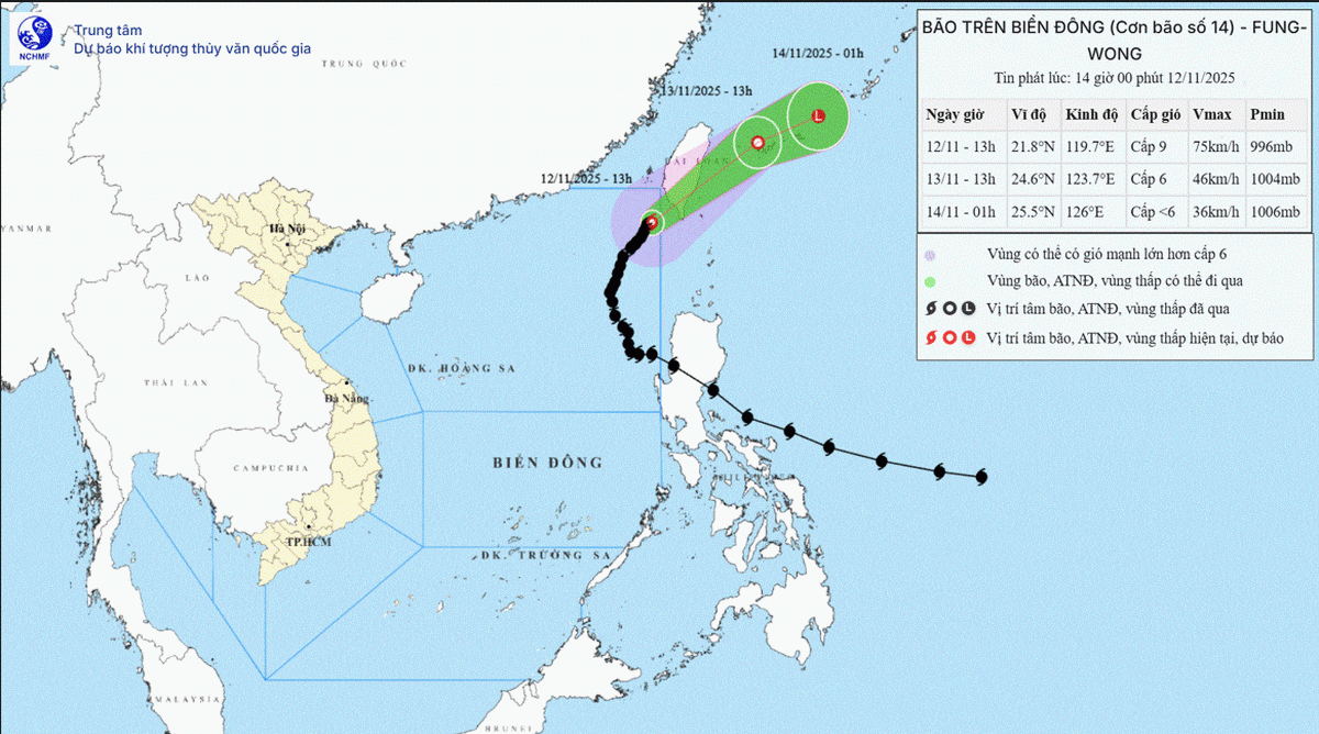
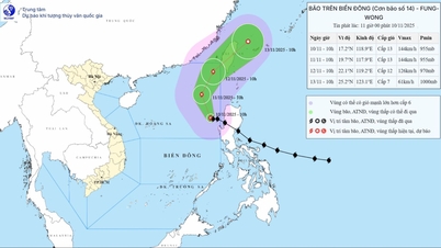
 |
| The representative of the Ministry of Foreign Affairs of Vietnam presented to the CLCS the dossier on the extended continental shelf beyond 200 nautical miles of Vietnam in the Central East Sea area on July 17, 2024. (Source: Vietnam Mission to the UN) |
International regulations on the extended continental shelf beyond 200 nautical miles
According to Article 76, paragraph 1 of UNCLOS, the continental shelf of a coastal State comprises the seabed and subsoil of the submarine areas that extend beyond its territorial sea throughout the natural prolongation of its land territory to the outer edge of the continental margin, or to a distance of 200 nautical miles from the baselines from which the territorial sea is measured if the continental margin does not extend up to that distance.
Article 76, paragraphs 4-10 of UNCLOS stipulates that the coastal state determines the extended continental shelf beyond 200 nautical miles (NLM), not exceeding 350 nautical miles from the baseline for calculating the breadth of the territorial sea or located at a distance of not more than 100 nautical miles from the 2,500 meter isobath.
Coastal States submit information on the continental shelf to the Commission on the Limits of the Continental Shelf (CLCS). The CLCS is one of three bodies established under UNCLOS, with the function of reviewing and sending recommendations on the limits of the continental shelf to coastal States.
The maritime boundary delimitations established by the coastal State on the basis of the recommendations of the CLCS are final and binding. In the event of a territorial or maritime dispute, the CLCS will not consider or evaluate the maritime boundary delimitation submissions of any State involved in the dispute. However, the CLCS may consider submissions in a disputed area with the prior consent of all parties to the dispute.
Practice in the East Sea - Impact and Prospects
According to Article 4 of Annex II of UNCLOS, a coastal State intending to determine the outer limits of its continental shelf beyond 200 nautical miles under Article 76 must submit to the CLCS as soon as possible and in any case within 10 years from the entry into force of the Convention. This period was later adjusted to 10 years starting from 13 May 1999 (i.e. 13 May 2009).
On that basis, a number of countries bordering the East Sea have complied with the prescribed deadline and submitted the TLĐMR dossier in the region.
On May 6, 2009, Vietnam submitted its EEZ beyond 200 nautical miles to the CLCS, including a separate submission in the northern part of the East Sea and a joint submission with Malaysia in the southern part of the East Sea. On December 12, 2019, Malaysia submitted its EEZ beyond 200 nautical miles in the East Sea.
On June 14, 2024, the Philippines submitted a dossier on the EEZ beyond 200 nautical miles. On July 17, 2024, Vietnam submitted a dossier on the EEZ beyond 200 nautical miles in the Central South China Sea, which is also Vietnam's third submission in the South China Sea. Up to this point, China and Brunei are claimants in the South China Sea but have not announced the submission of the EEZ in this area.
Through the submissions of the TLMR dossiers of the countries, some points can be drawn as follows: First, the countries all argued for the submission of the TLMR dossiers on the basis of applying the provisions of Article 76 of UNCLOS. Second, the countries recognized the possibility of overlapping titles for the TLMR areas beyond 200 nautical miles, and the dossiers would not prejudice the delimitation of maritime zones between countries. Third, some countries objected to the TLMR dossiers because they were directly related to the issue of sovereignty .
The most notable point related to the TLĐMR dossiers in the East Sea region is the reaction of many countries, inside and outside the region, to China's circulated diplomatic notes and its claim stance in the East Sea.
In 2009, after Vietnam and Malaysia submitted the TLĐMR dossier, China publicly circulated the nine-dash line map for the first time without providing any explanation of the legal basis. At that time, Vietnam, the Philippines, and Indonesia circulated notes to the United Nations to protest China's nine-dash line claim.
Later, the Final Award of the Arbitral Tribunal in the South China Sea Case on July 12, 2016 concluded that China's nine-dash line claim has absolutely no legal basis.
In 2019, after Malaysia submitted the TLĐMR dossier, China for the first time "internationalized" its claim to the "South China Sea Islands" (also known as the Four Sha) in a diplomatic note circulated at the United Nations.
For the first time, in addition to the claimants, many countries outside the region such as the US, Australia, UK, Germany, France, Japan, and New Zealand have spoken out against China's maritime claims because they exceed the scope permitted by UNCLOS, of which China is a member state. China continues to make territorial and maritime claims in its notes protesting the Philippines and Vietnam's 2024 submissions to the UNCLOS.
Up to now, a number of countries in and outside the region such as Vietnam, the Philippines, the US, the UK, France, and Germany have spoken out against China's inappropriate maritime claims, which exceed the scope allowed in its diplomatic notes.
Assessing the prospects for resolving the TLĐMR dossiers in the East Sea, it is unlikely that the CLCS will soon consider, evaluate and make recommendations, as some relevant countries have expressed their opposition to these dossiers. Unless, in the future, if the relevant parties in the East Sea agree to let the CLCS consider them, the CLCS can carry out the relevant procedures.
However, some international experts believe that these records do not affect the delimitation, so it is not excluded that the TLĐMR records can be considered the initial basis for future continental shelf delimitation agreements.
 |
| Oil and gas exploitation activities at Bach Ho field. (Source: Vietsovpetro) |
UNCLOS-Legal basis
With the submissions of the TPP in the East Sea, countries have partly clarified their legal views and maritime zones to ensure their maritime interests. The overall picture and legal situation in the region have become clearer.
However, due to the geological characteristics of the area and the differences in the methods of determining the TLĐMR of the countries, there is a possibility of additional overlapping areas appearing between the parties involved, which could make the dispute situation in the area more complicated in the future.
In addition, it can be seen that, through the TLĐMR records, the international community is increasingly concerned about the East Sea, when more and more voices openly and directly oppose China's maritime claims that are inconsistent with international law.
This further affirms the role of the UNCLOS Convention as the legal basis in determining the scope of maritime zones, and the importance of compliance, interpretation, and goodwill application of the Convention's provisions, and the necessity of ensuring legal order in the East Sea for peace, stability, and development.
The Commission on the Limits of the Continental Shelf (CLCS) is one of three specialized bodies established within the framework of UNCLOS, alongside the International Tribunal for the Law of the Sea (ITLOS) and the Seabed Authority (ISA). The functions, tasks and organizational structure of the CLCS are specified in Annex II of UNCLOS. The CLCS, consisting of 21 members, who are experts in the fields of geology, geophysics or hydrology, has the following functions: (i) To examine information and documents submitted by coastal states (CVB) relating to the outer limits of the continental shelf in areas where these limits exceed 200 nautical miles, and to make recommendations in accordance with Article 76; (ii) To provide scientific and technical advice, if requested by the countries concerned in the process of preparing information relating to the outer limits of the continental shelf. In case of disagreement with the recommendation of CLCS, QGVB may adjust or submit a new dossier to CLCS. The activities of the CLCS are without prejudice to questions concerning maritime boundary delimitation between States with opposite or adjacent coasts. According to statistics up to 2025, CLCS has received 95 TLĐMR dossiers from many UNCLOS member countries and 11 TLĐMR dossiers have been adjusted by countries. Currently, 45 dossiers have been reviewed and recommendations have been made by CLCS, 13 dossiers are under further review. |
Source: https://baoquocte.vn/them-luc-dia-mo-rong-ngoai-200-hai-ly-quy-dinh-va-thuc-tien-315164.html


![[Photo] Lam Dong: Panoramic view of Lien Khuong waterfall rolling like never before](/_next/image?url=https%3A%2F%2Fvphoto.vietnam.vn%2Fthumb%2F1200x675%2Fvietnam%2Fresource%2FIMAGE%2F2025%2F11%2F20%2F1763633331783_lk7-jpg.webp&w=3840&q=75)

![[Photo] National Assembly Chairman Tran Thanh Man holds talks with South Korean National Assembly Chairman Woo Won Shik](/_next/image?url=https%3A%2F%2Fvphoto.vietnam.vn%2Fthumb%2F1200x675%2Fvietnam%2Fresource%2FIMAGE%2F2025%2F11%2F20%2F1763629724919_hq-5175-jpg.webp&w=3840&q=75)
![[Photo] President Luong Cuong receives President of the Senate of the Czech Republic Milos Vystrcil](/_next/image?url=https%3A%2F%2Fvphoto.vietnam.vn%2Fthumb%2F1200x675%2Fvietnam%2Fresource%2FIMAGE%2F2025%2F11%2F20%2F1763629737266_ndo_br_1-jpg.webp&w=3840&q=75)


Comment (0)