
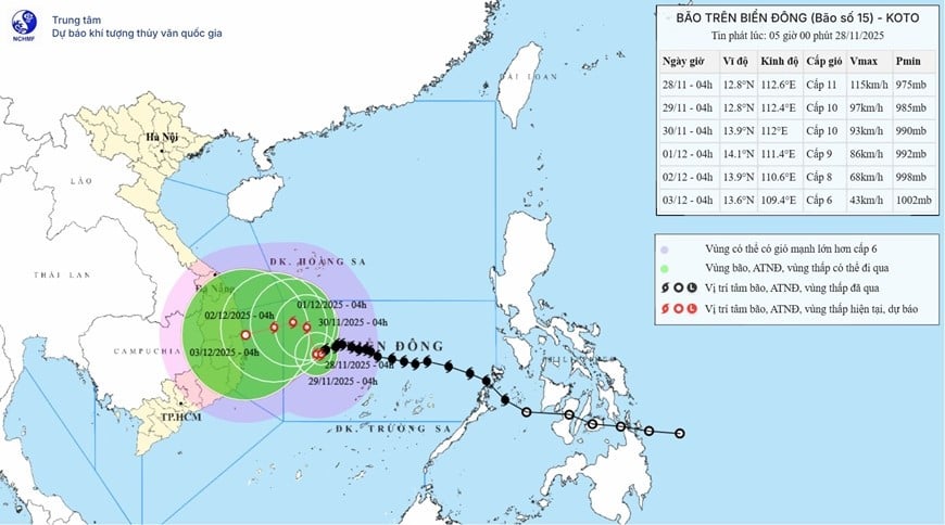
From the next 72 to 120 hours, the storm will move slowly to the West, then likely change direction to the West Southwest at a speed of about 5km/hour and continue to weaken.
The Central South China Sea Area (including the northern sea area of the special zone) Truong Sa) has strong winds of level 7-9; the area near the storm's eye has strong winds of level 10-11, gusting to level 14; waves 4-6m high, the area near the storm's eye is 7-9m; the sea is very rough.
Offshore waters from Gia Lai to Khanh Hoa Strong winds of level 6-7, then increasing to level 8, gusts of level 9-10, waves 5-7m high, rough seas.
Vessels operating in the above mentioned dangerous areas are susceptible to the impact of storms, whirlwinds, strong winds and large waves.
Detailed weather forecast for the areas:
Hanoi City: Partly cloudy, no rain at night, sunny during the day. Northeast to North wind level 2-3. Cold at night and morning. Lowest temperature 11-14 degrees Celsius. Highest temperature 24-26 degrees Celsius.
Northwest: Partly cloudy, no rain at night, sunny during the day. Light wind. Cold at night and morning, some places very cold. High mountain areas should be on guard for the possibility of frost. Lowest temperature 9-12 degrees Celsius, some places below 8 degrees Celsius. Highest temperature 23-26 degrees Celsius.
Northeast: Partly cloudy, no rain at night, sunny during the day. Northeast to North wind level 2-3. Cold at night and morning, some mountainous areas are very cold. High mountainous areas should be on guard for the possibility of frost. Lowest temperature 11-14 degrees Celsius, some mountainous areas below 9 degrees Celsius. Highest temperature 23-26 degrees Celsius.
Thanh Hoa to Hue: Cloudy in the North, no rain at night, sunny during the day; cloudy in the South, some rain. North to Northwest wind level 3, coastal areas level 4. Cold at night and morning. Lowest temperature 12-15 degrees Celsius, in the South 16-19 degrees Celsius. Highest temperature 22-25 degrees Celsius.
South Central Coast: Cloudy, scattered showers and thunderstorms. Northeast to North wind level 3, gusting to level 6-7 in some places. There is a possibility of tornadoes, lightning and strong gusts during thunderstorms. Lowest temperature 21-24 degrees Celsius. Highest temperature 25-28 degrees Celsius, in the South some places over 29 degrees Celsius.
Central Highlands: Cloudy, scattered showers and thunderstorms. Northeast wind level 3. Thunderstorms may cause tornadoes, lightning and strong gusts. Lowest temperature 15-18 degrees Celsius. Highest temperature 23-26 degrees Celsius, some places over 26 degrees Celsius.
Southern region: Cloudy, scattered showers and thunderstorms. Northeast wind level 3. Thunderstorms may cause tornadoes, lightning and strong gusts. Lowest temperature 21-24 degrees Celsius, below 21 degrees Celsius in some places. Highest temperature 29-32 degrees Celsius.
Ho Chi Minh City: Cloudy, scattered showers and thunderstorms. Northeast wind force 3. Thunderstorms may cause tornadoes, lightning and strong gusts of wind. Lowest temperature 21-24 degrees Celsius. Highest temperature 30-32 degrees Celsius.
Source: https://baolangson.vn/thoi-tiet-hom-nay-28-11-bao-so-15-cach-dao-song-tu-tay-khoang-240km-5066271.html


Comment (0)