
It is forecasted that from early morning of November 20 to night of November 21, Da Nang , eastern Quang Ngai and northern Lam Dong will have moderate to heavy rain, rainfall of 50-100mm, some places over 150mm. Eastern Gia Lai and southern Khanh Hoa will have rain of 70-150mm, some places over 200mm. Particularly, eastern Dak Lak and northern Khanh Hoa will have very heavy rain of 150-250mm, locally over 450mm.
The Southern region will have scattered showers and thunderstorms on the day and night of November 20, with some areas experiencing heavy rain of 10-30mm, and locally over 50mm, concentrated in the evening. During thunderstorms, beware of tornadoes, lightning, hail, and strong gusts of wind.
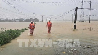
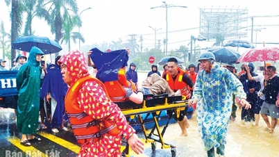
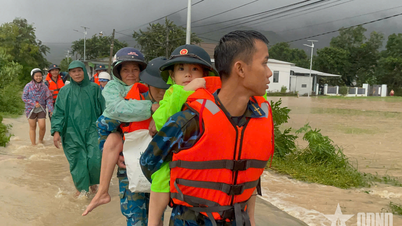
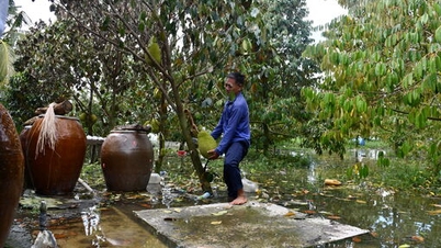
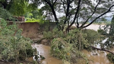
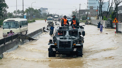
Regarding the flood situation, the Kon River has peaked and is receding. The flood on the Ba River is at its peak; the flood on the Dinh Ninh Hoa River, the Cai Nha Trang River, the Cai Phan Rang River and the Krong Ana River continues to rise; the flood on rivers from Hue to Khanh Hoa is generally receding.
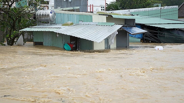
Photo: Sy Thang/VNA
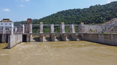
In the next 6 hours, the flood on Ba River may peak, exceeding the historical flood level of 1993 (5.21m), then slowly decrease. In the next 12 hours, the flood on Ba River will maintain a high level above alert level 3; the flood on Kon River will decrease below alert level 3; the flood on Krong Ana River will continue to rise below alert level 3; and the flood on Thu Bon River will decrease below alert level 2.
In the next 12-24 hours, flood on Ba River will remain at a high level above alert level 3; Kon River will drop below alert level 2; Krong Ana River will rise to alert level 3; flood on Thu Bon River will decrease to above alert level 1. In the next 24 hours, flood on Huong, Bo, Vu Gia, Tra Khuc Rivers will fluctuate between alert level 1, alert level 2 and above alert level 2; rivers in Dak Lak and Khanh Hoa will continue to rise to alert level 2, alert level 3, and in some places will exceed alert level 3.
Widespread flooding is occurring from Hue City to Khanh Hoa, with a high risk of flash floods and landslides on steep slopes.
At sea, the North East Sea has strong northeast winds of level 7-8, gusts of 9-10; Bach Long Vy, Con Co, Hon Ngu, Ly Son recorded strong winds of level 6-8, gusts of level 9. It is forecasted that during the day and night of November 20, the North East Sea (including Hoang Sa sea area) will have winds of level 7-8, gusts of 9-10, rough seas, waves of 4-6m. The Gulf of Tonkin has winds of level 6, gusts of 7, waves of 3-5m.
The sea area from South Quang Tri to Quang Ngai and the North Central East Sea has winds of level 6-7, gusts 8-9; from Gia Lai to Ca Mau, winds of level 6, gusts 7-8; Ca Mau to An Giang and the Gulf of Thailand, winds of level 5-6, gusts 7. The Central and South East Sea (including the Truong Sa sea area) has scattered showers and thunderstorms.
Weather forecast for regions across the country:
Hanoi capital is cloudy, no rain, sunny in the afternoon. Northeast wind level 2-3. Cold. Lowest temperature 14-16 degrees Celsius. Highest temperature 20-22 degrees Celsius, some places above 22 degrees Celsius.
The Northwestern provinces are cloudy, no rain, the clouds will decrease and there will be sunshine in the afternoon. Light wind. Cold, some places are very cold. Lowest temperature 13-16 degrees Celsius, some places below 11 degrees Celsius. Highest temperature 19-22 degrees Celsius.
The Northeast region is cloudy, no rain, the clouds will decrease and there will be sunshine in the afternoon. Northeast wind level 2-3. Cold weather, some mountainous areas are very cold. The lowest temperature is 13-16 degrees Celsius, some high mountainous areas are below 10 degrees Celsius. The highest temperature is 20-23 degrees Celsius.
Provinces from Thanh Hoa to Hue are cloudy with rain in some places. North to northwest wind level 2-3, coastal areas level 3-4. Cold weather. Lowest temperature 15-18 degrees Celsius. Highest temperature 19-22 degrees Celsius.
The South Central Coast region is cloudy with moderate to heavy rain, locally very heavy rain and thunderstorms; especially in the East of Dak Lak and Khanh Hoa provinces, there will be heavy to very heavy rain. Northeast wind level 3-4, coastal areas level 4-5, some places level 6, gusting to level 7. During thunderstorms, there is a possibility of tornadoes, lightning and strong gusts. The lowest temperature is 19-22 degrees Celsius, in the South some places 22-24 degrees Celsius. The highest temperature is 24-27 degrees Celsius, in the South some places 28-30 degrees Celsius.
The Central Highlands is cloudy with rain, showers and thunderstorms in some places; in the East of Dak Lak and Lam Dong provinces, there will be moderate rain, heavy rain, and locally very heavy rain. Northeast wind level 3. During thunderstorms, there is a possibility of tornadoes, lightning and strong gusts of wind. Lowest temperature 16-19 degrees Celsius. Highest temperature 23-26 degrees Celsius.
The South is cloudy, with scattered showers and thunderstorms in the afternoon and evening, with heavy rain in some places. Northeast wind level 2-3. During thunderstorms, there is a possibility of tornadoes, lightning and strong gusts of wind. Lowest temperature 23-26 degrees Celsius. Highest temperature 29-32 degrees Celsius, some places above 32 degrees Celsius.
Ho Chi Minh City is cloudy, with scattered showers and thunderstorms in the afternoon and evening. Northeast wind level 2-3. During thunderstorms, there is a possibility of tornadoes, lightning and strong gusts of wind. Lowest temperature 23-25 degrees Celsius. Highest temperature 30-32 degrees Celsius.
Source: https://baotintuc.vn/xa-hoi/thoi-tiet-ngay-2011-mua-lon-lu-len-nhanh-o-mien-trung-nguy-co-cao-lu-quet-va-sat-lo-dat-20251120055744734.htm
![[Photo] President Luong Cuong receives Speaker of the Korean National Assembly Woo Won Shik](/_next/image?url=https%3A%2F%2Fvphoto.vietnam.vn%2Fthumb%2F1200x675%2Fvietnam%2Fresource%2FIMAGE%2F2025%2F11%2F21%2F1763720046458_ndo_br_1-jpg.webp&w=3840&q=75)
![[Photo] National Assembly Chairman Tran Thanh Man holds talks with President of the Senate of the Czech Republic Milos Vystrcil](/_next/image?url=https%3A%2F%2Fvphoto.vietnam.vn%2Fthumb%2F1200x675%2Fvietnam%2Fresource%2FIMAGE%2F2025%2F11%2F21%2F1763715853195_ndo_br_bnd-6440-jpg.webp&w=3840&q=75)

![[Photo] General Secretary To Lam receives President of the Senate of the Czech Republic Milos Vystrcil](/_next/image?url=https%3A%2F%2Fvphoto.vietnam.vn%2Fthumb%2F1200x675%2Fvietnam%2Fresource%2FIMAGE%2F2025%2F11%2F21%2F1763723946294_ndo_br_1-8401-jpg.webp&w=3840&q=75)

![[Photo] Visit Hung Yen to admire the "wooden masterpiece" pagoda in the heart of the Northern Delta](/_next/image?url=https%3A%2F%2Fvphoto.vietnam.vn%2Fthumb%2F1200x675%2Fvietnam%2Fresource%2FIMAGE%2F2025%2F11%2F21%2F1763716446000_a1-bnd-8471-1769-jpg.webp&w=3840&q=75)


Comment (0)