
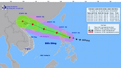
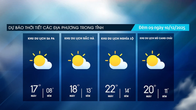
According to the National Center for Hydro-Meteorological Forecasting, in the next 24-72 hours, storm number 3 will develop as follows:
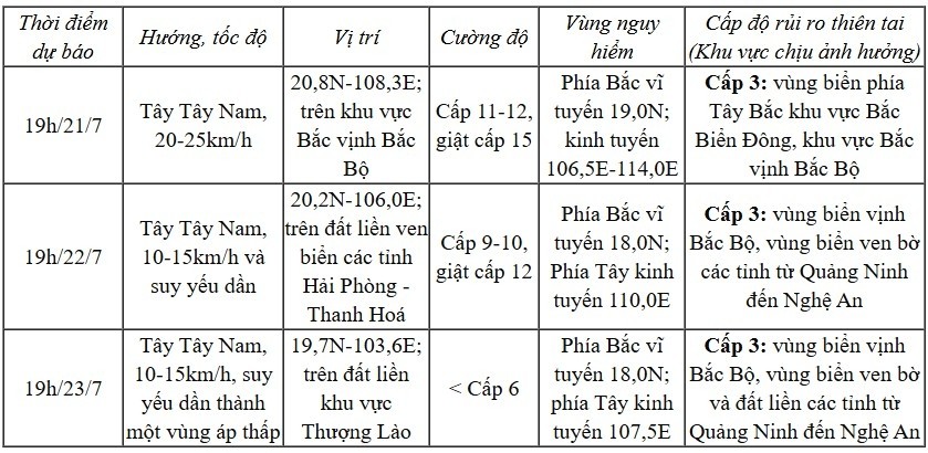
Forecast: Northwestern sea area of North East Sea, wind level 8-9, near the storm center level 10-11, gust level 14; waves 5-7m high, rough sea. In the North Gulf of Tonkin, wind gradually increases to level 6-7, then increases to level 8-9, near the storm center level 10-12, gust level 15; waves 2-5m high, rough sea.
In the southern Gulf of Tonkin, wind level 6-7, near the storm center level 8-9, gust level 11; waves 2-4m high, very rough seas.
On land, from the evening and night of July 21, coastal areas from Quang Ninh to Nghe An will have strong winds of level 7-9, near the storm center, level 10-11, gusting to level 14. Inland areas, strong winds of level 6-7, gusting to level 8-9.

Coastal areas of Hai Phong - Quang Ninh will see water rise by 0.8-1.2 m. The highest water level at Hon Dau is 3.8-4.2 m; Cua Ong 4.8-5.2 m; Tra Co 3.8-4.4 m. There is a high risk of flooding in coastal areas and river mouths at noon and afternoon on July 22.
Therefore, the National Center for Hydro-Meteorological Forecasting recommends that ships and boats not operate in the affected areas. Warning of prolonged heavy rain, risk of flash floods, landslides in mountainous areas and flooding in low-lying areas. Special attention should be paid to areas with total rainfall exceeding 200-300mm/period.
Source: https://baolaocai.vn/tin-moi-nhat-ve-bao-so-3-giat-cap-14-cach-quang-ninh-hai-phong-480km-post649304.html

![[Photo] Urgently help people soon have a place to live and stabilize their lives](/_next/image?url=https%3A%2F%2Fvphoto.vietnam.vn%2Fthumb%2F1200x675%2Fvietnam%2Fresource%2FIMAGE%2F2025%2F12%2F09%2F1765248230297_c-jpg.webp&w=3840&q=75)


![[Photo] General Secretary To Lam works with the Standing Committees of the 14th Party Congress Subcommittees](https://vphoto.vietnam.vn/thumb/402x226/vietnam/resource/IMAGE/2025/12/09/1765265023554_image.jpeg)


Comment (0)