
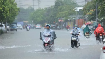
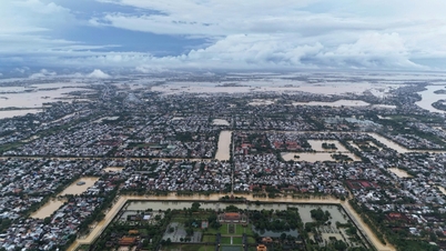
By the morning of October 30, the whole province had nearly 20 landslides, 44 flooding points on national highways and provincial roads, 27 points on inter-commune and village traffic routes, more than 534 houses were flooded, and about 5,000 students at 27 schools had to temporarily close to ensure safety.
Specifically, there are 6 flooded points on national highways, including: National Highway 15D at Dakrong spillway/Km0+307, in La Lay commune, flooded 0.25m; National Highway 49C at Km9+200-Km9+400 in Trieu Binh commune, flooded 5-10cm, Km30+450-Km30+950 flooded 10-15cm, Km32+950-Km33+600 flooded 20-30cm, Km33+600-Km35+500 in Vinh Dinh commune, flooded 50-70cm, Km36+750-Km41+076 in My Thuy commune, flooded 60-80cm...
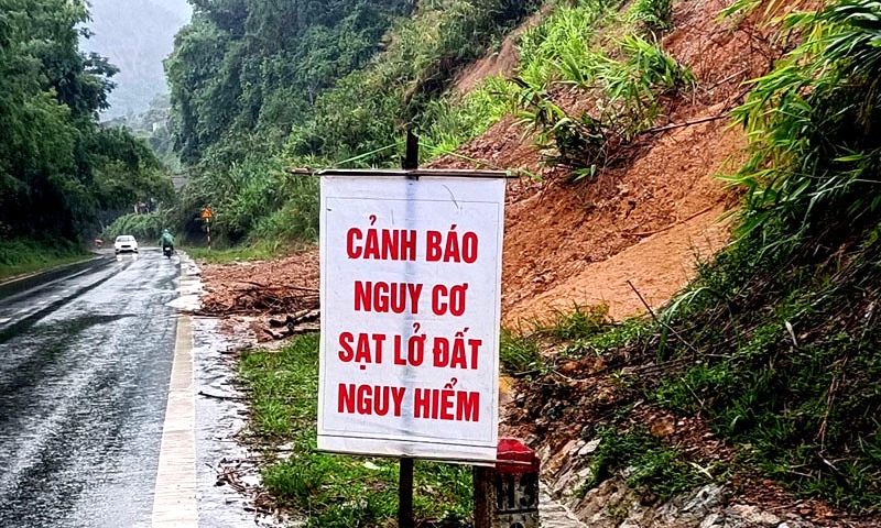 |
| Many traffic routes are at high risk of landslides and danger due to prolonged heavy rain. |
Provincial roads have 11 flooded points, including: Provincial Road 565C at Km2+400-Km7+300 is flooded 0.4-0.6m, Provincial Road 564 at Km0+00-Km7+300 is flooded 15-20cm, Provincial Road 582 at Km3+400, Km5+300 in Dien Sanh commune is flooded 30-40cm, Km8+600-Km9+420 in Vinh Dinh commune is flooded 20-25cm, Provincial Road 582b at Km3+400-Km3+700, Km4+700-Km5+290 in Dien Sanh commune is flooded 30-40cm, Provincial Road 584 at Km8+050-Km9+180 in Dien Sanh commune is flooded 20-25cm, Km9+700-Km16+800 in Dien Sanh commune and Nam Hai Lang commune is flooded 50-70cm, Provincial Road 588a at Ba Long spillway/Km11+240 in Ba Long commune is flooded about 1m, Provincial Road 571 at spillway Km1+700 in Khe Sanh commune is flooded 15cm, Provincial Road 587 at La La spillway Km1+700 is flooded 15cm.
In addition, inter-village and inter-commune roads have 27 flooded points in the communes of Hoan Lao (2 points), Kim Ngan (3 points), La Lay (2 points), Vinh Dinh (7 points), Huong Lap (1 point), Ba Long (7 points), Dakrong (3 points), and Ta Rut (2 points).
The whole province has evacuated 137 households/385 people in Ba Long, Nam Hai Lang, My Thuy, Dien Sanh communes and 14 officers and soldiers of La Lay International Border Guard Station to ensure safety.
Statistics as of the morning of October 30 showed that heavy rains and floods had flooded more than 101 hectares of crops in My Thuy and Ai Tu communes; nearly 2 kilometers of canals were damaged, and 1.3 kilometers of riverbanks were eroded.
There are 3 landslides on national highways, including: National Highway 9C at Km29+100, Km38+400 (Kim Ngan commune) with a 60m long positive slope landslide, with a volume of about 2,500m 3 ; National Highway 9B at Km 77+700 (Kim Ngan commune) with a positive slope landslide, with a volume of about 3,500m 3 ; National Highway 9 at Km48+120-140 with a positive slope landslide, with a volume of about 200m 3 . Provincial roads have 7 landslides, including: Provincial Road 587, section Km4-Km12, with many locations where the road surface was eroded, creating deep ditches, making traffic difficult. In particular, landslides, slides, and road surface erosion occurred at 4 locations, including: Km5+200 with dimensions of 8x4x2m, Km6+300 with dimensions of 10x3x3m, Km10+600 with dimensions of 10x3x3m, and Km13+100 with dimensions of 7x3x2m. Provincial Road 571 had a negative slope landslide at Km24+820 with dimensions of 30x7x4m; a positive slope landslide at Km22+800 with dimensions of 45x5x2m, 1,290m 3 . In Nam Hai Lang commune, there are 2 points at the culvert of the Tay Son inter-village traffic road at risk of erosion due to heavy rain; the rural traffic road in the Nhu Son area, Dong Son village had landslides and damage along a length of 15m. In Dakrong commune, there are 2 landslide points on National Highway 9 (km48+120) with a volume of about 200m 3 ; landslide on the internal road of Ly Ton village, Dakrong commune with a volume of about 300m 3. In Le Thuy commune, there is 1 point on the inter-commune road 30 with a slope landslide of about 50m. In Kim Ngan commune, in the area of Lang Ho Border Guard Station, there are 2 landslide points at km 39+200 on National Highway 9C with a volume of about 20 to 25m 3 ; at Km29+100 National Highway 9C, there is a landslide of more than 100m 3 of earth and rock. In Huong Hiep commune, there is 1 landslide point on the traffic route to Ta Bung hamlet, Xa Vi village with about 50m 3 of earth.
Nguyen Hoang
Source: https://baoquangtri.vn/xa-hoi/202510/toan-tinh-co-hang-chuc-diem-sat-lo-ngap-lut-do-mua-lon-f216863/
![[Photo] Touching scene of thousands of people saving the embankment from the raging water](https://vphoto.vietnam.vn/thumb/1200x675/vietnam/resource/IMAGE/2025/10/30/1761825173837_ndo_br_ho-de-3-jpg.webp)
![[Photo] The Third Patriotic Emulation Congress of the Central Internal Affairs Commission](https://vphoto.vietnam.vn/thumb/1200x675/vietnam/resource/IMAGE/2025/10/30/1761831176178_dh-thi-dua-yeu-nuoc-5076-2710-jpg.webp)
![[Photo] General Secretary To Lam attends the Vietnam-UK High-Level Economic Conference](https://vphoto.vietnam.vn/thumb/1200x675/vietnam/resource/IMAGE/2025/10/30/1761825773922_anh-1-3371-jpg.webp)


Comment (0)