

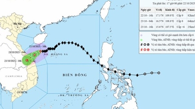
Image of storm No. 12 at noon on October 22
The National Center for Hydro-Meteorological Forecasting forecasts that on the afternoon of October 22, storm No. 12 will move into the sea area of Hue City - Quang Ngai, and its intensity will continue to weaken to level 8. On the night of October 22 and the morning of October 23, the storm will weaken into a tropical depression, moving inland from Hue to Quang Ngai provinces and cities. On the morning and afternoon of October 23, the storm will move into the Southern Laos area, weakening into a low pressure area.
According to the National Center for Hydro-Meteorological Forecasting, due to the impact of cold air, the intensity of storm No. 12 is not too strong (maximum level 10), and cannot increase in intensity like storms No. 10 (BUALOI), 11 (MATMO). When entering the Hoang Sa special zone, it is blocked by a cold air mass, so it changes direction and moves slowly.
Although the storm's intensity is not too high, it is still forecast to cause heavy rain on land because the storm's circulation brings a large amount of moisture from the East Sea to the mainland, combined with strong northeast winds in the East Sea and the Gulf of Tonkin and east wind disturbances. The convergence of wind and moisture from the three systems mentioned above is even stronger due to the wind-blocking effect of the Truong Son range in the Central region, causing the rain to intensify and last for many days, even after the storm dissipates.
Due to the combination of the strengthening cold air, in the Gulf of Tonkin there are strong northeast winds of level 7, gusting to level 9. The sea area from Quang Tri to Quang Ngai (including Con Co special zone, Cu Lao Cham island and Ly Son special zone) has strong winds of level 6-7, the area near the storm's center has winds of level 8, gusting to level 10, waves 3-5 m high, rough seas.
Coastal areas from Quang Tri to Da Nang have storm surges of 0.4-0.8 m. There is a high risk of flooding in low-lying areas, coastal roads, and coastal erosion due to large waves combined with high tides and wind surges.
From the afternoon of October 22, on the mainland coastal provinces from Quang Tri to Da Nang, the wind will gradually increase to level 6-7, gusting to level 8-9. The strongest wind will be around tonight (October 22) to the morning of October 23. Coastal areas will be level 6-7, gusting to level 8-9. Inland areas will be level 5, gusting to level 6-8. Mountainous areas will be level 4, sometimes level 5, gusting to level 6-7.
Beware of the risk of thunderstorms, tornadoes and strong gusts of wind in the storm's circulation area, both before and during the storm's landfall.
2 heavy, prolonged rains
According to the National Center for Hydro-Meteorological Forecasting, due to the impact of the storm, there will be two large-scale and prolonged periods of heavy rain.
Phase 1 from the night of October 22-24: Due to the combined influence of storm circulation No. 12 combined with cold air and East wind, Quang Tri - Da Nang has rainfall from 400-600 mm, locally heavy rain over 800 mm, heavy rain >200 mm/3 hours.
In Ha Tinh and Quang Ngai areas, rainfall ranges from 100-250 mm, locally over 400 mm.
This rain season warns of the risk of flooding in urban and industrial areas due to heavy rain and rising sea levels causing slow drainage.
Phase 2 from October 25-27: Rain due to the influence of cold air combined with East wind, Quang Tri, Hue have 200-300 mm of rain, locally over 500 mm. Ha Tinh, Da Nang, Quang Ngai have 100-200 mm of rain, locally over 300 mm. After October 27, rain is likely to continue in the Central region.
With the current rainfall, plus the forecasted rainfall from October 22 to October 30 in the Quang Tri - Quang Ngai area increasing by 500-700 mm, the total rainfall will be 20-40% higher than the annual average.
Thu Cuc
Source: https://baochinhphu.vn/2-dot-mua-lon-keo-dai-tai-cac-tinh-tu-ha-tinh-den-quang-ngai-102251022125250163.htm


![[Photo] Award Ceremony of the Political Contest on Protecting the Party's Ideological Foundation](https://vphoto.vietnam.vn/thumb/1200x675/vietnam/resource/IMAGE/2025/10/22/1761151665557_giaia-jpg.webp)
![[Photo] Da Nang: Shock forces protect people's lives and property from natural disasters](https://vphoto.vietnam.vn/thumb/1200x675/vietnam/resource/IMAGE/2025/10/22/1761145662726_ndo_tr_z7144555003331-7912dd3d47479764c3df11043a705f22-3095-jpg.webp)
![[Photo] Prime Minister Pham Minh Chinh chairs meeting on nuclear power plant construction](https://vphoto.vietnam.vn/thumb/1200x675/vietnam/resource/IMAGE/2025/10/22/1761137852450_dsc-9299-jpg.webp)


Comment (0)