
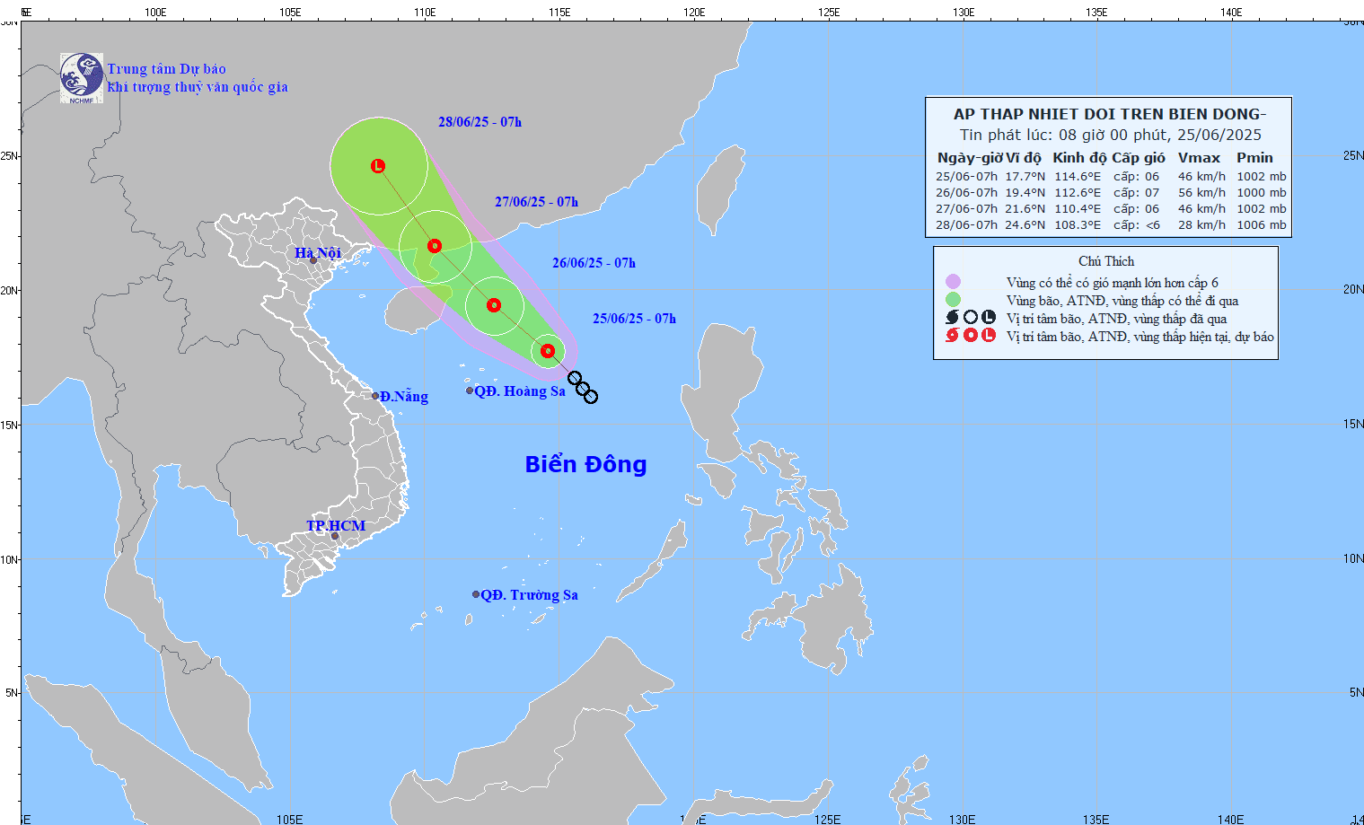
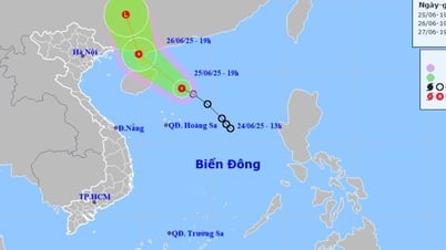
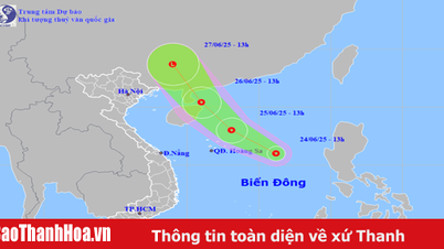
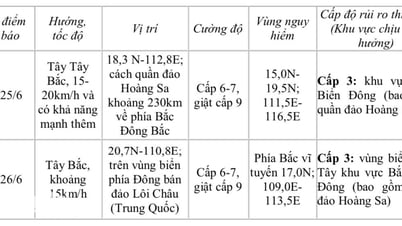
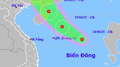
According to the National Center for Hydro-Meteorological Forecasting, as of 7:00 a.m. this morning (June 25), the center of the tropical depression was at about 17.7 degrees North latitude; 114.6 degrees East longitude, about 360km East Northeast of Hoang Sa archipelago.
The strongest wind near the center is level 6 (39-49 km/h), gusting to level 8. The tropical depression is moving northwest at a speed of 15-20 km/h.
Forecast for the next 24 to 48 hours
By 7am tomorrow morning (June 26), the tropical depression will be about 180km east of Hainan Island (China). The intensity is forecast to increase to level 6-7, with gusts of level 9.
The dangerous area in the East Sea in the next 24 hours (strong winds from level 6 or higher, gusts from level 8 or higher) is in the range from 16.5-21 degrees North latitude and from 111.5-115.5 degrees East longitude. The level of risk of natural disasters due to strong winds at sea is level 3.
The meteorological agency said that by 7am on June 27, the tropical depression continued to move northwest at a speed of about 15km/h and gradually weakened, located on the mainland southwest of Guangdong province (China). At this time, the intensity decreased to level 6, gusting to level 8.
The danger zone extends to the North, above the 18th parallel North latitude, from 109-113.5 degrees East longitude. Disaster risk level: level 3.
Many areas across the country have heavy rain.
The meteorological agency said that due to the strong activity of the low pressure trough in the Northwest - Southeast direction with an axis through the Central region and the middle of the East Sea. The Southwest monsoon in the Southern region is operating at an average intensity, so many areas across the country have heavy rain.
Forecast, today and tonight June 25, in the Northwest region and the Northern Delta, there will be scattered showers and thunderstorms, locally heavy rain with rainfall from 15-30mm, locally over 80mm.
This evening and tonight, the Viet Bac region will have rain, moderate rain and scattered thunderstorms, locally heavy to very heavy rain with rainfall from 15-40 mm, locally over 150 mm.
At the same time, this afternoon and evening, in the South Central region, there will be scattered showers and thunderstorms, locally heavy rain with rainfall of 10-30 mm, locally over 80 mm.
Hai Duong area: According to the provincial Hydrometeorological Station, at 9:00 a.m. this morning, June 25, there was a convective cloud area developing and causing rain in the Hung Yen and Thai Binh provinces, with a tendency to move towards Hai Duong province. It is forecasted that in the next 30 minutes to a few hours, this convective cloud area will continue to move and cause showers and thunderstorms for Hai Duong city, Chi Linh city and the districts of Binh Giang, Cam Giang, Gia Loc, Tu Ky, Kinh Mon, Nam Sach, Kim Thanh, Ninh Giang, Thanh Mien...
During thunderstorms, be careful of lightning, tornadoes and strong winds that can break trees, damage houses, traffic works and infrastructure, endangering human life.
PVSource: https://baohaiduong.vn/ap-thap-nhiet-doi-giat-cap-8-hai-duong-co-mua-dong-414925.html

![[Photo] More than 124,000 candidates in Hanoi complete procedures for the 2025 High School Graduation Exam](https://vphoto.vietnam.vn/thumb/1200x675/vietnam/resource/IMAGE/2025/6/25/fa62985b10464d6a943b58699098ae3f)
![[Photo] First training session in preparation for the parade to celebrate the 80th anniversary of National Day, September 2nd](https://vphoto.vietnam.vn/thumb/1200x675/vietnam/resource/IMAGE/2025/6/25/ebf0364280904c019e24ade59fb08b18)

![[Photo] General Secretary To Lam works with the Standing Committee of Quang Binh and Quang Tri Provincial Party Committees](https://vphoto.vietnam.vn/thumb/1200x675/vietnam/resource/IMAGE/2025/6/25/6acdc70e139d44beaef4133fefbe2c7f)


Comment (0)