
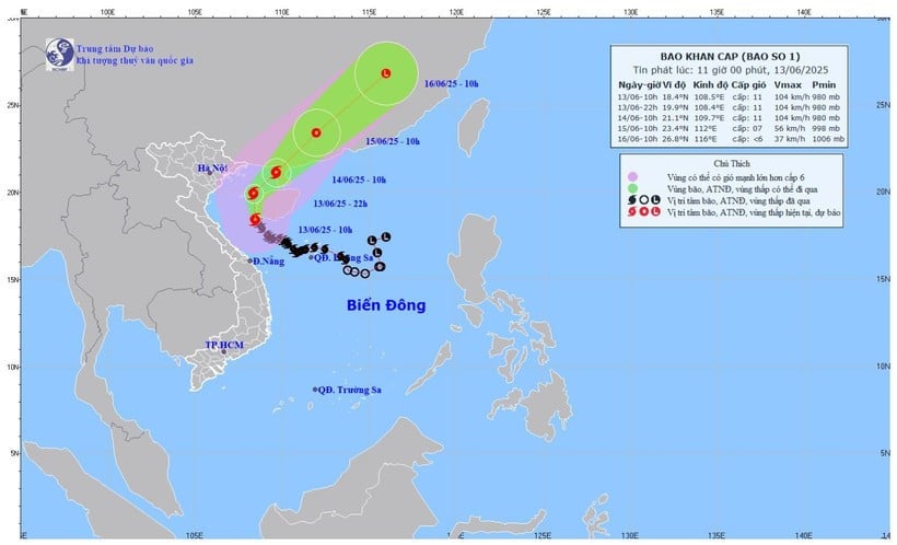
According to the National Center for Hydro-Meteorological Forecasting, in the next 3 hours, the storm will move north at a speed of about 10-15km/hour.
Due to the influence of storm circulation No. 1, in the Gulf of Tonkin there are strong winds of level 6-7, gusting to level 8-9.
The Gulf of Tonkin (including Co To and Bach Long Vi island districts) has strong winds of level 7-8, near the storm's eye level 9-11, gusting to level 14, waves 2-4m high, especially in the east 3-5m, rough seas.
The northwest of the northern East Sea and offshore waters from Quang Tri to Da Nang have strong winds of level 6-8, near the storm center level 9-11, gusting to level 14, waves 3-5m high, near the storm center 4-6m high, rough seas.
Ships operating in the above mentioned dangerous areas are likely to be affected by storms, whirlwinds, strong winds and large waves.
In coastal areas, due to the influence of high tides and storm surges, the Hai Phong - Nghe An sea area is likely to experience high sea levels (Hon Dau: 3.9m, Hon Ngu: 2.8m), causing localized flooding in some low-lying coastal and river mouth areas between 5-7pm on June 13 and 14.
On land, from noon and afternoon of June 13, the coastal area of Quang Ninh-Hai Phong will have strong winds of level 6, gusting to level 7-8; the coastal area of Thai Binh- Nam Dinh will have strong winds of level 4-5, gusting to level 6-7.
On June 13, the area from Quang Binh to Hue will have heavy to very heavy rain with common rainfall of 50-100mm, some places over 200mm; the area of Southern Nghe An, Ha Tinh, from Da Nang to Quang Nam and Kon Tum has moderate rain, heavy rain, locally very heavy rain and thunderstorms with common rainfall of 20-40mm, some places over 100mm.
Source: https://baolangson.vn/bao-so-1-bat-ngo-manh-len-cap-11-giat-cap-14-di-vao-sau-vinh-bac-bo-5049974.html


Comment (0)